UDOT PLANNED AVALANCHE CLOSURES!!

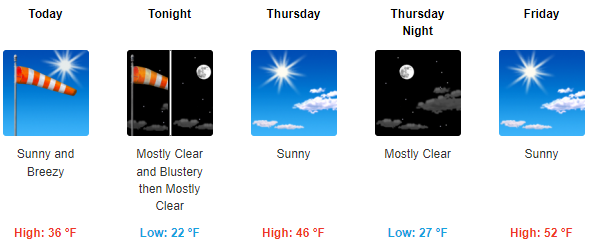
Forecast for the Abajos Area Mountains

Dave Garcia
Issued by Dave Garcia for
Wednesday, March 23, 2022
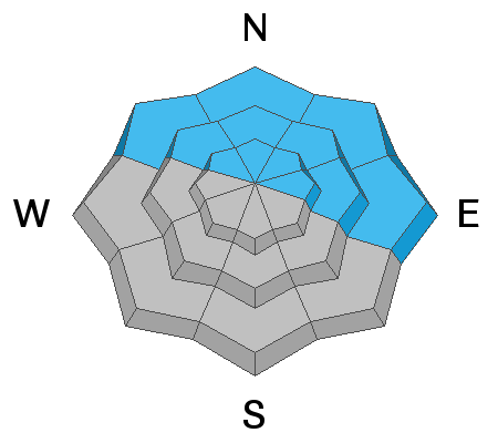
There is a MODERATE danger for triggering an avalanche on a buried persistent weak layer on slopes steeper than 30 degrees facing NW-N-NE-E at all elevations. Avalanches failing on this layer will be over 2 feet deep. Careful slope by slope analysis is critical for safe backcountry travel today. You will also find a MODERATE danger for triggering avalanches in recent wind drifted snow on all aspects above tree line. Fresh drifts are easily recognized by their smooth rounded appearance.
Low
Moderate
Considerable
High
Extreme
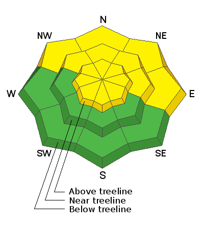
Learn how to read the forecast here
Special Announcements
Please help support avalanche forecasting throughout Utah. Donate to the Spring Campaign to help raise the funds to support the forecasting you rely on.
Weather and Snow
High, thin clouds over the mountains this morning will give way to mostly sunny skies. North winds will blow for the third day in a row. The winds blew strong over night and are currently blowing 20-30 mph. Expect the winds to continue in the 20-25 mph range with occasional strong gusts up to 40 mph. Temperatures will climb higher than yesterday and will reach the mid 30's. Look for warmer temperatures tomorrow, and things will really heat up for the weekend.
Snow totals and temps at Buckboard SNOTEL (8924')
Snow totals and temps at Camp Jackson SNOTEL (8858')
Snowpack
A quick moving low pressure system dropped a few inches of snow Sunday night into Monday morning. This was a nice refresh, but strong spring sun and even stronger North winds have left a variety of crusts in exposed terrain. The best snow remains in sheltered locations on shady slopes. You'll need to be aware of lingering pockets of wind drifted snow above tree line today. The buried persistent weak layer of faceted snow that formed during the Jan-Feb high pressure remains the primary concern and it is still capable of producing dangerous, human triggered avalanches over two feet deep on all slopes facing the north side of the compass.
This video was shot in the La Sals on Tuesday, but is a good representation of conditions in the Abajo Mountains.
Recent Avalanches
There are no recent reports of avalanches from the Abajo range.
Avalanche Problem #1
Persistent Weak Layer
Type
Location
Likelihood
Size
Description
A persistent weak layer of loose, sugary faceted snow exists on NW-N-NE-E aspects beneath a slab that is 2'-3' thick. In my recent travels I am still finding the weakest snow on northerly aspects right around treeline and below. Above treeline this problem is being compounded by recent wind drifted snow. Blowing and drifting snow is increasing the weight and depth of the existing slab. The additional weight will put even more stress on the buried weak layer of facets, pushing this layer even closer to its breaking point. Stability tests show that avalanches are becoming harder to trigger on this layer, but the additional load from the wind will increase the likely hood for triggering an avalanche today.
Avalanche Problem #2
Wind Drifted Snow
Type
Location
Likelihood
Size
Description
North winds have been blowing and drifting snow on to all aspects above tree line since Sunday night. The bulk of wind slab formation occurred on Monday. On Tuesday I observed only occasional light snow transport. You will find slabs of wind drifted snow along ridge lines, gully walls, below convexities, and along the sides of mid slope moraines. Today wind drifted snow will be stiff and harder to trigger, and this has the potential to lure you further down into a starting zone. Areas of heightened concern are steep Northerly slopes that were cross loaded on Monday. This should get your attention, as these aspects also harbor the buried persistent weak layer. Recent drifts are recognizable by their smooth rounded appearance and they may sound hollow underneath. Avoid steep slopes where you can detect recent deposits of wind drifted snow.
General Announcements
Who's up for some free avalanche training? Get a refresher, become better prepared for an upcoming avalanche class, or just boost your skills. Go to https://learn.kbyg.org/ and scroll down to Step 2 for a series of interactive online avalanche courses produced by the UAC.
This forecast is from the U.S. Forest Service, which is solely responsible for its content. This forecast describes general avalanche conditions and local variations always occur.