Forecast for the Abajos Area Mountains

Eric Trenbeath
Issued by Eric Trenbeath for
Sunday, March 13, 2022
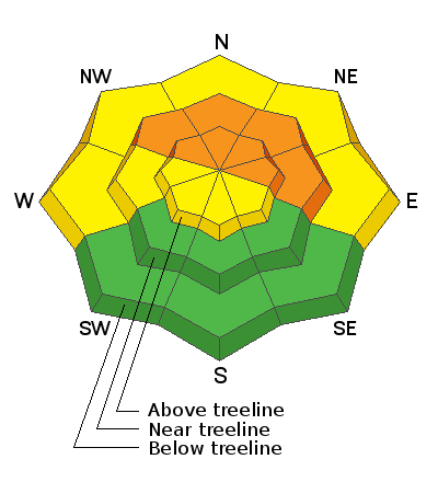
The avalanche danger remains CONSIDERABLE on steep slopes facing NW-N-NE-E and human triggered avalanches failing on a buried persistent weak layer 1'-2' feet deep are likely. A MODERATE danger for triggering this type of avalanche exists on W facing slopes. Most S facing terrain has LOW danger.
Low
Moderate
Considerable
High
Extreme
Learn how to read the forecast here
Weather and Snow
I hope you got up to the mountains yesterday and enjoyed the beautiful weather as it's not going to be so nice today. A fast moving storm system will clip by to the north bringing increasing clouds and blustery SW winds blowing in the 20-25 mph range with gusts as high as 40 along ridgetops. We'll see a slight chance for snow tonight before the storm moves on and winds shift to the NW. Monday and Tuesday look dry and sunny followed by another system moving into the region on Wednesday. This one doesn't look particularly promising but we may get a refresh of a few inches.
Snow totals and temps at Buckboard SNOTEL (8924')
Snow totals and temps at Camp Jackson SNOTEL (8858')
Snowpack
Dangerous avalanche conditions exist in all zones throughout Utah, and most of Colorado. This is due to a buried persistent weak layer of loose, sugary, faceted snow that formed near the snow surface during the extended dry period of Jan-Feb. This faceted weak layer now sits beneath a slab up to 2' deep. In my travels on the Manti-Skyline on Friday with forecaster Brett Kobernik, we met a party of snowmobilers who had remotely triggered a very large avalanche from below the slope. Yesterday, Brett and Trent from the SLC office were able to intentionally trigger numerous avalanches failing on this weak layer and at least one snowmobiler was lucky to escape a large slide that he triggered. Our snowpacks share similarities with the primary difference being that we are a little further out from the last loading event. These are unusual conditions for this time of year. Time heals all wounds but I'm afraid this one is taking awhile, and the likelihood for triggering an avalanche on a steep, northerly facing slope remains very real.
Recent Avalanches
It was an active day throughout the state for human triggered avalanches with almost all of the other zones reporting accidents and near misses. I commend the restraint of our users who generally play it safe down here.
Avalanche Problem #1
Persistent Weak Layer
Type
Location
Likelihood
Size
Description
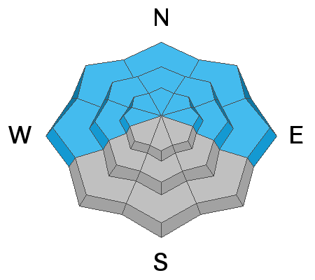
A persistent weak layer of sugary, faceted snow sits beneath a slab 1'-2' thick. New and wind drifted snow now sits on top of this slab adding more stress to the buried weak layer. Human triggered avalanches failing on this weak layer are likely, primarily on steep slopes facing NW-N-NE-E but W facing slopes are also suspect.
Avalanche Problem #2
Wind Drifted Snow
Type
Location
Likelihood
Size
Description
Shifting winds over the past few days have blown and drifted snow on to all aspects at upper elevations. SW winds yesterday created fresh drifts on northerly facing slopes. In these areas, newly drifted snow has added more weight and stress to the buried persistent weak layer increasing the likelihood for a deeper, more dangerous avalanche. Wind drifts are recognizable by their smooth, rounded appearance and cracking is a sign of instability. Avoid steep wind drifted slopes, especially those facing the north side of the compass.
General Announcements
Who's up for some free avalanche training? Get a refresher, become better prepared for an upcoming avalanche class, or just boost your skills. Go to https://learn.kbyg.org/ and scroll down to Step 2 for a series of interactive online avalanche courses produced by the UAC.
This forecast is from the U.S. Forest Service, which is solely responsible for its content. This forecast describes general avalanche conditions and local variations always occur.