Join us at our 2nd Annual Blizzard Ball

Forecast for the Abajo Area Mountains

Eric Trenbeath
Issued by Eric Trenbeath on
Tuesday morning, February 7, 2017

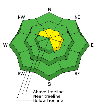
The avalanche danger is mostly LOW this morning but will could increase to MODERATE later in the day as wind and blowing snow create newly formed wind slabs in upper elevation, wind exposed terrain. Be alert to changing conditions and watch for fresh wind drifts forming on the lee sides of ridge crests and terrain features such as gully walls, sub-ridges, and beneath rock buttresses.
Low
Moderate
Considerable
High
Extreme
Learn how to read the forecast here
Special Announcements

The Abajo/Blue Mountain avalanche advisory will provide detailed information on the weekends. During the week, general information and a danger rating will be posted.

Weather and Snow

A moist Pacific storm system will move though the region today but we are well out of the cross hairs. Most of the energy is passing through to the north and we'll see mostly windy conditions with perhaps a few inches of snow.The snow surface is getting tired and worn from the wind and sun and a variety of crusted surfaces abound Overall snow depth now ranges from 2-4' across the range.

Dustin Randall was out yesterday and sent in this observation.

Wind speed, temperature, and humidity on Abajo Peak.

New snow totals at Camp Jackson.

Additional Information

Today

Snow likely before noon, then a chance of rain and snow. Areas of blowing snow before 11am. Cloudy, with a high near 36. Breezy, with a southwest wind 15 to 25 mph, with gusts as high as 35 mph. Chance of precipitation is 60%. Total daytime snow accumulation of 1 to 2 inches possible.

Tonight

A 20 percent chance of snow before 4am. Patchy blowing snow after 9pm. Mostly cloudy, with a low around 30. Breezy, with a west southwest wind 20 to 25 mph, with gusts as high as 35 mph.

Wednesday

Mostly sunny, with a high near 38. Breezy, with a west wind 10 to 20 mph, with gusts as high as 30 mph.

Wednesday Night

Partly cloudy, with a low around 33. West southwest wind 10 to 15 mph.

Thursday

Partly sunny, with a high near 44. Breezy, with a west southwest wind 15 to 20 mph, with gusts as high as 30 mph.

General Announcements

If you are getting out into the mountains, we love to hear from you! You can SUBMIT OBSERVATIONS ONLINE

If you would like to have avalanche advisories emailed to you, SIGN UP HERE

Benefit the Utah Avalanche Center when you shop from Backcountry.com or REI: Click this link for Backcountry.com or this link to REI, shop, and they will donate a percent of your purchase price to the UAC. Both offer free shipping (with some conditions) so this costs you nothing!

Benefit the Utah Avalanche Center when you buy or sell on ebayIf you sign up for AmazonSmile and designate the Utah Avalanche Center as your favorite charity, they will donate a portion of everything you spend to the UAC. I doesn't cost you a penny and we'd really appreciate the help.​

The information in this advisory is from the US Forest Service which is solely responsible for its content. This advisory describes general avalanche conditions and local variations always occur.