Forecast for the Abajos Area Mountains

Eric Trenbeath
Issued by Eric Trenbeath for
Thursday, January 17, 2019
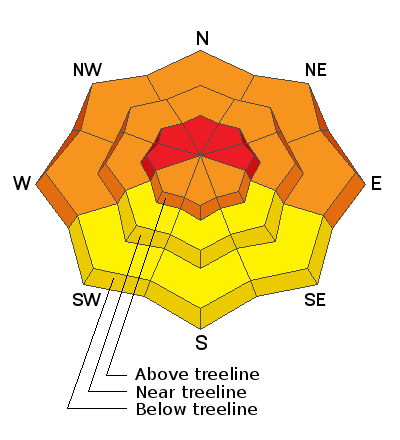
DANGEROUS AVALANCHE CONDITIONS WILL EXIST FOR THE NEXT SEVERAL DAYS! The avalanche danger is HIGH today as new snow and wind drifted are dangerously overloading a fragile snowpack. Natural and human triggered avalanches breaking 2'-4' deep are likely on steep slopes that face W-N-E. Avalanches within the most recent snow are possible on all aspects. Travel in avalanche terrain is not recommended. Backcountry travelers need to possess excellent route finding skills and know how to stay off of, and out from under, steep, avalanche prone terrain.
Low
Moderate
Considerable
High
Extreme
Learn how to read the forecast here
Avalanche Warning
THE FOREST SERVICE UTAH AVALANCHE CENTER IN MOAB HAS ISSUED A BACKCOUNTRY AVALANCHE WARNING.
* TIMING... 6 AM MST THURSDAY THROUGH 6 AM MST FRIDAY.
* AFFECTED AREA...FOR THE LA SAL AND ABAJO MOUNTAINS OF SOUTHEASTERN UTAH
* AVALANCHE DANGER...THE AVALANCHE DANGER HAS RISEN TO HIGH.
* REASON/IMPACTS...RECENT SNOW COMBINED WITH HEAVY SNOW EXPECTED LATER TODAY WILL LIKELY CREATE WIDESPREAD AREAS OF UNSTABLE SNOW AND DANGEROUS AVALANCHE CONDITIONS. BOTH HUMAN TRIGGERED AND NATURAL AVALANCHES WILL BE LIKELY. STAY OFF OF AND OUT FROM UNDER SLOPES STEEPER THAN 30 DEGREES.
Special Announcements
We will be offering a Backcountry 101 avalanche course on Feb 8, 9. It's a great way to up your avalanche knowledge with both classroom, and hands on field instruction. Click here for more details and to register.
The new UAC IOS mobile app is now available on the app store. Check out the new "My Weather" feature.
Check out the new free online avalanche course series developed by the Utah Avalanche Center. This is a great way to refresh your skills or prepare you for a Backcountry 101 or Level 1 class.
Weather and Snow
8"-12" of dense, heavy snow fell in the mountains Tues night into Wed morning. Moderate to strong southerly winds accompanied most of the snowfall, but then they tapered off and were pretty well behaved most of the day yesterday. They are currerntly blowing in the 15-25 mph range. Temps are in the low 20's. Today, look for increasing SW winds ahead of the next storm system approaching our area. Snowfall should begin this afternoon with the heaviest period coming in tonight. At least another foot of snow is possible.
Snow totals at Buckboard Flat (8924')
Snow totals at Camp Jackson (8858')
Wind, temperature, and humidity on Abajo Peak (11,000')
National Weather Service point forecast.
Recent Avalanches
The Abajo Mountains experienced a significant round of both human triggered and natural avalanche activity last week. Expect another round this week as new snow accumulates.
General Announcements
Your information can save lives. If you see anything we should know about, please help us out by submitting snow and avalanche observations HERE. You can also call me at 801-647-8896, or send me an email: [email protected].
Support the UAC through your daily shopping. When you shop at Smith's, or online at REI, Backcountry.com, Patagonia, NRS, Amazon, eBay by clicking on these links, they donate a portion of your purchase to the UAC. If you sell on eBay, you can have your See our Affiliate Page for more details on how you can support the UAC when you shop
This advisory is from the U.S.D.A. Forest Service, which is solely responsible for its content. This advisory describes general avalanche conditions and local variations always occur.