
With a potentially significant storm rolling into Utah for Saturday through Monday, here's an avalanche primer on what to expect:
The day before a major winter storm is forecast to arrive, you will see all of us avalanche geeks out mapping the distribution pattern of the preexisting snow. Answering the questions: 1. Where is the weak snow? 2) How weak is it? 3) What is the pattern? The answers to these questions will tell you where we will find avalanche danger once we slam a slab of snow down on top of it. Here is what I found in my fieldwork yesterday:
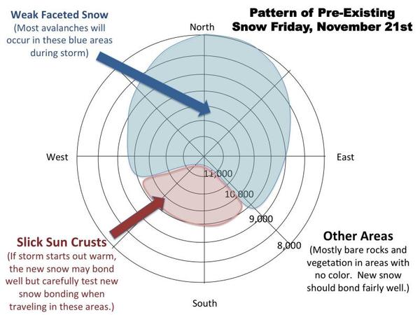
Last weekend with just a foot of new snow, we saw a lot of sensitive, avalanches on the upper elevation, northerly facing slopes. The snow near the ground had rotted away into very weak, sugarydepth hoar crystals and it did not take much to make things exciting. Well, that weak layer is still there and nearlyas fragileas it was last week. Plus, we will likely put down 2-3 times more weight on top with the storm this weekend. So this is not rocket surgery; we are going to have avalanches.
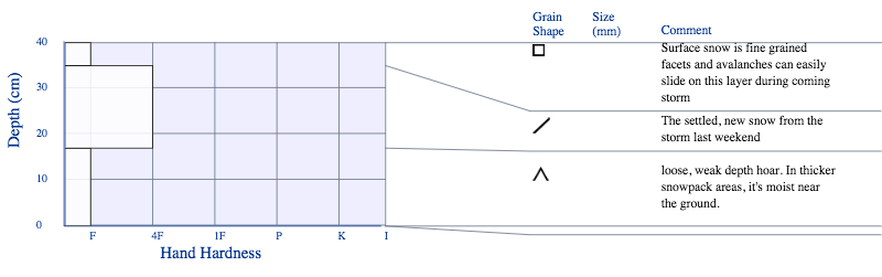
Here is the basic snowpack setup on the shady aspects: weak depth hoar near the ground, a soft slab on to from last Saturday's storm, then a skiff of soft snow on top, which is now fine grained faceted snow.
HERE is a video of my fieldwork yesterday so you can see it (nearly) in person:
Bottom line: This is not a very good weekend to get into the backcountry for two reasons: 1) It's rocky--real rocky--even in some of the upper elevation, northerly facing slopes. So wear your old equipment and lots of body armor. In this early season, new snow does not so much cover up rocks but conceal them. So it seems to me likeyou just hit more of them, many of which will toss you onto your head in yet another pile of rocks. 2) The slopes deepenough to cover up most of the rocks and shrubs are exactly the ones thatwill want to avalanche. So watch your slope steepness carefully. Stay under 30 degrees.


