Here are some charts of the backcountry avalanches in our database so far this season.
As usual, the aspect northeast comes up again and again. This is because of the combination between shady, cold slopes, wind deposits and slope steepness and the number of people. 1) Slopes facing the north half of the compass are colder because they are shadier, which form and preserve faceted snow, which causes almost all avalanches in our region. 2) Wind blows from the west, so it tends to drift snow onto the east facing slopes. 3) Because of the above two factors, glaciers from the Pleistocene carved out the northeast facing slopes, making them steeper. 4) Powder snow lasts longest on shady aspects, so people tend to congregate there. Thus, most of our human triggered avalanches occur on northeast facing slopes.
Hot tip: Right after a storm, head to the south facing slopes, both because they are safer (less faceted snow) and second, because it's the only time that south facing slopes are good. Give those northeast facing slopes with persistent weak layers time to settle and heal.

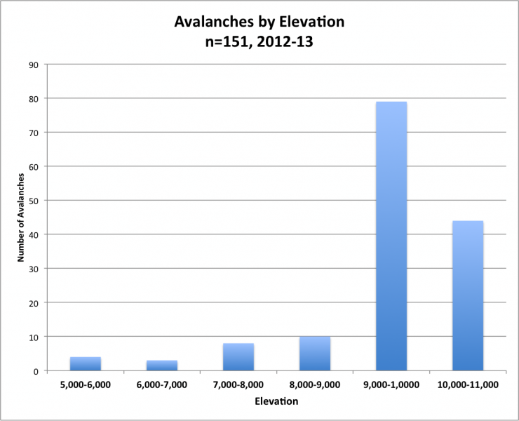
Next, elevation plays an important role because more snow and wind occur at higher elevations. So generally, the higher the elevation, the more avalanches we will find. However, we see fewer avalanches above above 10,000' only because in the Wasatch Range, most of that terrain is occupied by Snowbird and Alta and we don't count the avalanches from inside ski areas in this data set. Also, the high elevation, backcountry high terrain is more difficult to access.
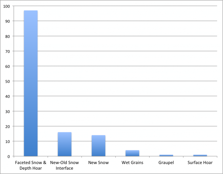
Almost all human triggered avalanches in Utah are from faceted snow as the weak layer, either as depth hoar (faceted snow formed near the ground in the early season) or near-surface faceted snow (faceted snow formed on the snow surface during clear weather).
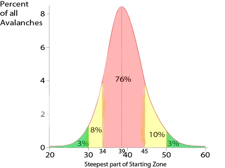
Finally, here is a graph from Swiss data showing slope steepness for human triggered avalanches in the backcountry. It includes over 1000 avalanches where the slope angle was measured. So this is probably the best dataset in the world. I have colored the graph red, yellow and green to make it easier to digest. My advice is to avoid all the red slopes (and slopes locally connected) in terrain that our avalanche advisory rates Considerable Danger and avoid all the red and yellow slopes (and slopes locally connected and runnout areas) when the danger is High or Extreme.
The range of 34-45 degrees is prime steepness with the bull's eye at 39 degrees. Remember, avalanche steepness does not vary by danger rating. Avalanches are avalanches. They occur on the same range of slope angles whether it's Moderate, Considerable or High avalanche danger. They occur on slightly steeper slopes at Low danger because most avalanches are sluffs, which occur on steeper slopes than slabs.