Donate to the 2024 Spring Campaign to help rebuild the UAC website.

Forecast for the Skyline Area Mountains

Brett Kobernik
Issued by Brett Kobernik for
Saturday, December 30, 2017

The majority of the terrain along the Skyline has a LOW danger. A lingering pocket may still release on the upper elevation north facing terrain if provoked. Keep in mind that even a small slide can beat you up since many rocks and logs are still exposed.

Low
Moderate
Considerable
High
Extreme
Learn how to read the forecast here
Weather and Snow

Temperatures have been unseasonably mild in the mountains over the last few days especially on Friday where ridge top temperatures hit 40˚F. The wind has been blowing in the moderate to strong speed range for the last two days. The biggest change this week is the new snow from the Christmas storm is starting to weaken noticeably. We now have enough snow on the east and west aspects that will continue to weaken over the next 10 days. That means that once we get more snow, west, north and east facing slopes are all going to have weak faceted sugary snow that will most likely produce avalanches.

Recent Avalanches

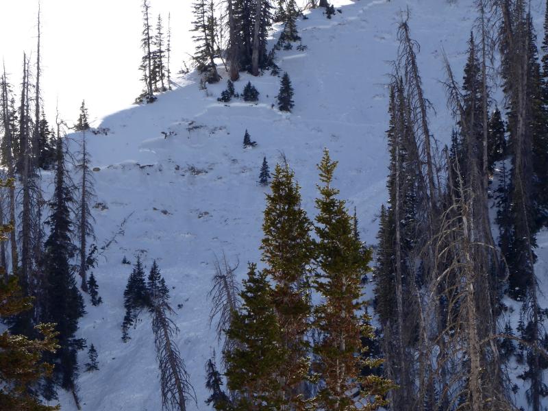
Friday, I found some more avalanches that released on Christmas Day. These were up in Pleasant Creek. They all broke into weak faceted snow near the ground. They were all north facing above 9600 feet. On our way up, my partner pointed out some old cracks from Christmas down as low as 9000'. A slope had "spiderwebbed" but didn't release. Below are some details and links to the observations:

12/25/2017 Skyline region: Avalanche: BBQ Bowl, Natural trigger - 10" deep

12/25/2017 Skyline region: Avalanche: Main Bowl, Natural trigger - 10" deep - 400' wide

Photo, natural avalanche in Pleasant Creek

Ad
Avalanche Problem #1
Persistent Weak Layer
Type
Location
Likelihood
Size
Description

Faceted sugary snow is difficult to deal with. It demands the utmost respect. It will sneak up on you long after you think things have stabilized.

In Friday's avalanche forecast, I removed the small wedge of MODERATE danger from the rose. When I was up in Pleasant Creek, my partner and I backed off of a route that ran directly underneath a short steep north facing slope. We were concerned that we still might trigger something. This means that there is still concern on those high north facing slopes so I've added the wedge of MODERATE danger back in the rose. I think it's fairly unlikely to trigger something at this point but it's not wise to trust a faceted sugary buried weak layer.

Additional Information
We'll have mostly sunny skies and warm temperatures again today. Ridge top highs will be in the upper 30s. West wind will be moderate to strong today ahead of a storm that will move through Saturday night that will just clip northern Utah. We'll see mostly clear skies and ridge top high temperatures in the low to mid 30s through the middle of next week. Otherwise, no significant storms for another 10 days. I do see that models are hinting at a larger storm from the southwest around January 9th. It's hard to count on a storm that far out in time. Hopefully, the models are right!
General Announcements

We will publish full detailed advisories Saturday and Sunday mornings by 7am. We will also be publishing basic avalanche danger ratings & info during the week.

If you are getting out into the mountains, we love to hear from you! You can SUBMIT OBSERVATIONS ONLINE or EMAIL US

If you would like to have avalanche advisories emailed to you, SIGN UP HERE

We can provide basic avalanche awareness presentations for your school, group or club. To enquire, CLICK HERE