UDOT PLANNED AVALANCHE CLOSURES!!

Forecast for the Salt Lake Area Mountains

Evelyn Lees
Issued by Evelyn Lees for
Thursday, March 1, 2018

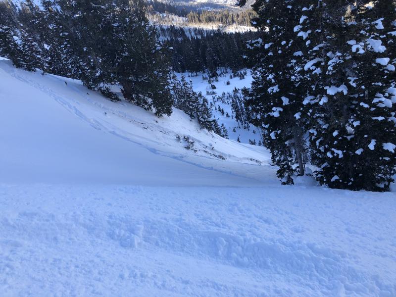
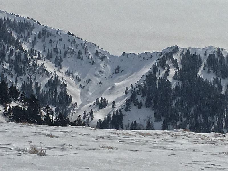
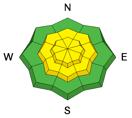
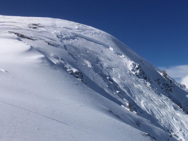
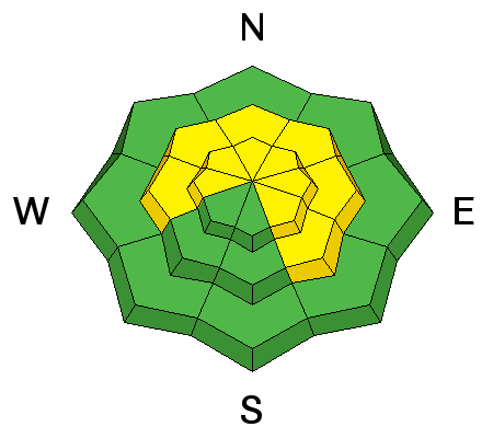
The avalanche danger is MODERATE on all steep, mid and upper elevation slopes. Wind drifts can be found around the compass, both along and well off the ridges and will increase in depth and distribution this afternoon as wind speeds increase. Deeper slides can be triggered on isolated slopes facing west through north through southeast, especially on slopes with a thinner snowpack.

With the complex snowpack, continue cautious route finding, careful snowpack evaluation and conservative decision-making.

You will find better and safer skiing and riding conditions on lower-angled wind sheltered slopes, with no steep slopes above.

Low
Moderate
Considerable
High
Extreme
Learn how to read the forecast here
Special Announcements

The Whole Foods Bag Donation to support the UAC has been extended to March 31. When you bring your own bags to Whole Foods in Sugar House, Trolley Square, and Cottonwood Heights you can choose to have the UAC be the recipient of your 10 cent bag credit.

Spend some time improving your rescue skills or learning about avalanches in this upcoming Salt Lake City area class:

Weather and Snow

Yesterday’s bluebird day has morphed into a graybird day…skies are mostly cloudy this morning and the southerly winds increasing. Mid elevations speeds are averaging 10 to 15 mph; the high ridgelines averaging 15 to 25 mph. Temperatures are warm, in the teens and twenties.

Amidst the wind slabs and crusted sunny slopes, soft dense powder remains on sheltered, shady slopes.

Recent Avalanches

Two slides were triggered in the backcountry yesterday – a soft slab failing on facets in an east-facing gully near Days Draw at 9400'. 2' deep by 50' wide, the natural was perhaps triggered by wet sluff. A very large cornice drop triggered a 2-foot deep by 80’ wide hard slab in a Wolverine Chute, also failing on facets.

A large slide was noted in Long John Silver, White Pine – perhaps a natural from Monday? It was a full width slab, and ran 3/4 track. One large wind slab was triggered with explosives on an upper elevation, northerly facing slope.

Main Days Fork slide, February 27th, Catino photo. Shallow snowpack, steep break over, slope that has slid already at least once this year.

Grandview Peak area, older slide from Monday winds?. Mark Staples photo.

Ad
Avalanche Problem #1
Wind Drifted Snow
Type
Location
Likelihood
Size
Description

A few new wind slabs will be created by today’s increasingly strong southerly winds, easy to trigger. They will be loaded on top of Monday’s pencil hard wind slabs, which are along ridge lines and scattered in open bowls and the mid elevations. The older, hard wind slabs are stubborn, but can still be triggered by a person, and be anywhere from a few inches to two feet deep. Hard slabs are different – they almost always break above you, and often on the second or third person.

Cornices are becoming more widespread along ridgelines – continuing to grow with today’s increasing southerly winds. Cornices often break back further than expected, on to what looks like flat terrain. So give them a wide berth and avoid travel below them.

Recent upper elevation hard wind slab avalanche. Eric Trembeth photo.

Avalanche Problem #2
Persistent Weak Layer
Type
Location
Likelihood
Size
Description

While many steep lines have been skied and ridden in the Salt Lake and Park City area mountains, avalanches continue to be triggered on buried layers of faceted snow. Many slopes have poor structure – soft sugary, weak layers, both mid-pack and near the ground. It seems some of the steep slopes are just waiting for a trigger – and which slopes will slide are variable and unpredictable.

A few deeper, wider slides broke near the ground this week, 2 to 5 feet deep. These natural avalanches were on Mill Canyon peak, in Mineral Fork and White Pine. They can be triggered by a person, smaller slides or cornice falls. Avoid, steep shallow, rocky, wind loaded terrain, where the snowpack is thinner and more suspect. If you trigger a persistent slab avalanche it will likely be unsurvivable.

Cracking and collapsing are bulls-eye clues to instability, but these clues may not be present, and snow pit tests could be unreliable.

Additional Information

A weak disturbance crossing northern Utah will increase the winds and produce an inch or two of snow this afternoon. Mostly cloudy skies today, with the southerly winds slowly increasing throughout the day. By evening, mid elevations ridge lines could average 25 mph with gusts to 30 mph, and the high elevations average 35 mph, gusting in the 50s. By morning, winds will be very strong. Temperatures will warm into the mid 20s to low 30s.

The next storm continues to look good, though slowing down – it will be preceded by strong winds starting after midnight and continuing all day Friday. The main cold front should arrive Saturday with periods of snow, heavy at times, continuing into Sunday. We are still hoping for one to two feet of snow at the higher elevations.

General Announcements

CLICK HERE FOR MORE GENERAL INFO AND FAQ

The UAC has new support programs with Outdoor Research and Darn Tough. Support the UAC through your daily shopping. When you shop at Smith's, or online at Outdoor Research, REI, Backcountry.com, Darn Tough, Patagonia, NRS, Amazon, eBay a portion of your purchase will be donated to the FUAC. See our Donate Page for more details on how you can support the UAC when you shop.

Benefit the Utah Avalanche Center when you buy or sell on eBay - set the Utah Avalanche Center as a favorite non-profit in your eBay account here and click on eBay gives when you buy or sell. You can choose to have your seller fees donated to the UAC, which doesn't cost you a penny

This information does not apply to developed ski areas or highways where avalanche control is normally done. This advisory is from the U.S.D.A. Forest Service, which is solely responsible for its content. This advisory describes general avalanche conditions and local variations always occur.