Issued by Drew Hardesty on Thursday morning, December 28, 2017
We have a solid CONSIDERABLE avalanche danger on many slopes in the backcountry. Even steep low elevation terrain - smaller, steep gullies, creek beds and road banks at the lower elevations - is suspect. Remember that these 1-2' deep and up to 300' wide avalanches are unmanageable - they can be triggered remotely from a distance and from below. Best to choose low angle slopes not connected to steeper terrain above.
Alta Ski Area is now open in the Supreme area. Alta is preforming avalanche work in this terrain. The area is closed to backcountry use.
The Park City ski resort is doing control work in preparation for opening in McConkeys, Jupiter, McDonald Draw, Condor, Dreamscape and the Peak(Chutes) areas for the next several days These areas are closed to backcountry use.
Brighton is now closed to uphill traffic through the New Year.
Discount lift tickets for Alta, Snowbird, Brighton, Solitude, Deer Valley, Snowbasin,and Beaver Mountain are now available, donated by the resorts to benefit the Utah Avalanche Center. Details and order information here. All proceeds go towards paying for avalanche forecasting and education!
Weather and Snow
Skies are clear with moumtain temperatures in the mid-20s. Westerly winds are 15-20mph, gusting to 35, and continue to be enough to transport and damage the Christmas powder. Upper elevations host snow depths of 3-4'. Despite the Christmas snow, we still have a long way to go to catch up. Pray harder.
Trent put together an excellent two minute piece below on current avalanche conditions. Or find it on YouTube.
Recent Avalanches
Cracking and collapsing remained the rule and not the exception yesterday. Yesterday's reported avalanches from the backcountry include:
Jim Clem area in a closed portion of Solitude Mtn Resort - 9200' NE facing: natural avalanche 20" deep and 350' wide failing on faceted snow.
Murdock Peak along the north end of the PC ridgeline - 9300' NE facing: remotely triggered avalanche 20" deep and 250' wide.
Mark Staples and USA (Utah Snowmobile Association) president Cal Taylor's excellent investigation of 4 partial burials in the Monte Cristo area (east of Huntsville) on Tuesday can be found here. (See video synopsis below). In brief, the riders triggered the 1/2 mile wide avalanche from below in this very close call. Interestingly, another party of UAC observers investigating the avalanche remotely triggered another, similar avalanche on an adjacent slope.
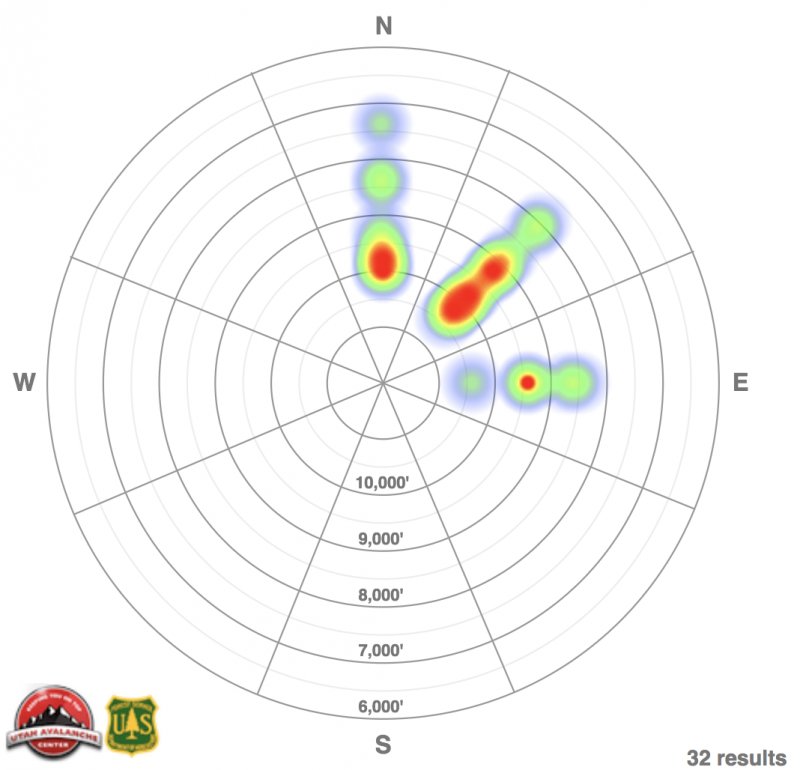
Heat map of aspects/elevations of avalanches in Logan, Ogden, SLC, Provo, and Uinta mountains below from 23 Dec to yesterday.
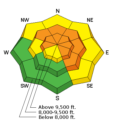
Avalanche Problem #1
Persistent Weak Layer
Type
Location
Likelihood
Size
Description
Collapsing and cracking continue to rule the day in the backcountry...and along with avalanche activity, are the surest indicators of avalanche danger. Anywhere we have recently buried weak faceted snow from early season is potentially suspect and dangerous. Insult to injury is that one doesn't need to be on a steep slope to trigger an avalanche. It's called collapse failure, remote triggering, or triggering from a distance and it's a function of the slab/weak layer interface that allows the crack to propagate wildly along the flats and up along the steep slope above you. Note how the overlying slab collapses the weak layer in the video below.
See the video from yesterday's remotely triggered avalanche near Monte Cristo.
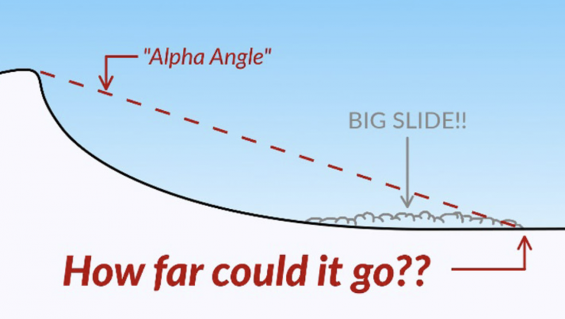
Hot Tip! - When natural activity is expected, when it's possible to trigger avalanches from below, or if people might trigger slides on top of you, you must understand runout angles. You can find a good article here. Also...Remember that 1/3 of bc tourers are caught while going uphill.
Avalanche Problem #2
Wind Drifted Snow
Type
Location
Likelihood
Size
Description
Gusty westerly winds will continue to create sensitive wind drifts in the more open exposed terrain. Once any snow gets moving, it could step down to one of the deeper weak layers, resulting in a much larger avalanche.
Additional Information
It'll be mostly sunny this morning with westerly winds in the 20-25 mph range. Temps will be in the mid to upper 30s while the highest peaks reach toward freezing by tomorrow. The only sure bet are the gusty westerlies over the next few days with mild weather and occasional clouds streaming through. Long term forecast looks bleak.
Support the UAC through your daily shopping. When you shop at Smith's, or online at REI, Backcountry.com, Patagonia, NRS,Amazon, eBay a portion of your purchase will be donated to the FUAC. See our Donate Page for more details on how you can support the UAC when you shop.
Benefit the Utah Avalanche Center when you buy or sell on eBay - set the Utah Avalanche Center as a favorite non-profit in your eBay account here and click on eBay gives when you buy or sell. You can choose to have your seller fees donated to the UAC, which doesn't cost you a penny
This information does not apply to developed ski areas or highways where avalanche control is normally done. This advisory is from the U.S.D.A. Forest Service, which is solely responsible for its content. This advisory describes general avalanche conditions and local variations always occur.