UDOT PLANNED AVALANCHE CLOSURES!!

Forecast for the Salt Lake Area Mountains

Drew Hardesty
Issued by Drew Hardesty for
Wednesday, December 27, 2017

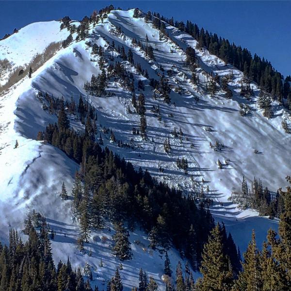
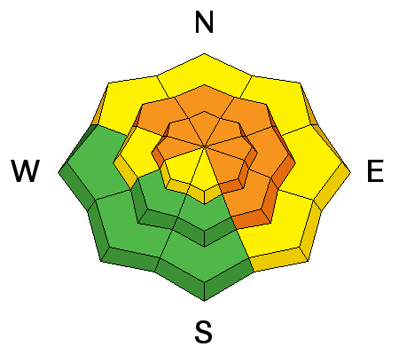
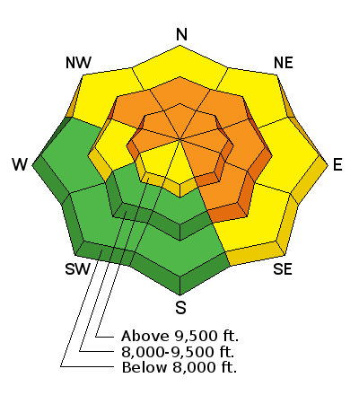
We have a solid CONSIDERABLE avalanche danger on many slopes in the backcountry. Even steep low elevation terrain - smaller, steep gullies, creek beds and road banks at the lower elevations​ - is suspect. Remember that these 1-2' deep and up to 300' wide avalanches are unmanageable - they can be triggered remotely from a distance and from below. Best to choose low angle slopes not connected to steeper terrain above.

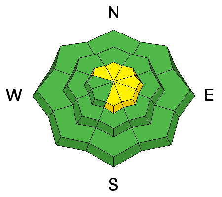
I'll be honest here: these are the types of days where we see avalanche accidents.

Low
Moderate
Considerable
High
Extreme
Learn how to read the forecast here
Special Announcements

Alta Ski Area is now open in the Supreme area. Alta is preforming avalanche work in this terrain. The area is closed to backcountry use.

The Park City ski resort is doing control work in preparation for opening in McConkeys, Jupiter, McDonalds Draw, Condor, Dreamscape and the Peak(Chutes) areas for the next several days​ These areas are closed to backcountry use.

Weather and Snow

Skies are clear, ain't it a shame.

Temperatures are in upper teens to low 20s.

Westerly winds blow 15-20mph, gusting to 30. 11,000' anemometers are recording hourly wind speeds near 30mph.

The Christmas storms dramatically improved coverage and conditions - the upper elevations now hold 3-4' snow on the ground. You'll find powder snow on all aspects but for some sun-crusted south and west facing terrain this morning.

Trent put together an excellent two minute piece below on current avalanche conditions. Or find it on YouTube.

Recent Avalanches

Cracking and collapsing remained the rule and not the exception yesterday. Reported avalanches from the backcountry include: (uncertain of these areas? - check out UAC board member Steve Achelis's Wasatch Backcountry Ski map - or better yet - the app)

  • Wilson Chutes x 2 - 9650' NE facing 12-18" deep perhaps 200' wide. (Animal tracks went into the starting zone and came out of the debris.)
  • Wilson Glades - -9600' North facing 1-2' deep reported 300' wide. Triggered from a distance. See pic from Mark White
  • George's Bowl in mid-Cardiff Fork of BCC - various remotely triggered slides (triggered from a distance) from 9800' down to 8000'.
  • Cardiff Bowl - 10k North facing - unknown trigger, reported up to 300' wide.
  • White Pine summer road - 8100' West NW facing - 1' deep 40' wide. Intentionally triggered from below.

Complete list of reported avalanches

Ski area control work continued to pull out numerous avalanches into the old weak faceted snow with some ripping out to the ground.

Ad
Avalanche Problem #1
Persistent Weak Layer
Type
Location
Likelihood
Size
Description

Long time ski guide Roger Atkins has a wonderfully insightful paper on matching terrain selection to the avalanche conditions. It's called Yin, Yang, and You. A hidden gem in the essay is of the human condition and how we find joy in this world. It's appropriately called The Selection of Desires. Long story short, he argues - and I believe this to be true - that if our only joy is in the steep and the deep, then it's likely we won't last too long. There is joy, too, in low angle powder snow.


The persistent slab problem can be found on nearly all aspects above about 7500' and most pronounced on west to north to southeast facing slopes. All the bull's eye clues to danger are present: avalanches, collapsing, cracking.

There are a few options:

Look for evidence of faceted snow (Trent's video above or the one below.) Avoid being on or beneath steep terrain if you find this weak snow. Remember you can trigger these avalaches down on top of you even from low angle terrain.

Use test slopes to determine sensitivity. Test slopes are steep, representative aspects/elevations pieces of terrain that can reveal a great deal of avalanche information. They should not, however, be used to declare representative slopes safe.

Bottom Line: if you want steep terrain - find aspects and elevations where the old faceted snow does not exist (many south and southwest facing slopes). Otherwise, find joy in the low angle powder snow with nothing steep above.

Avalanche Problem #2
Wind Drifted Snow
Type
Location
Likelihood
Size
Description

Gusty west to southwest winds will continue to create sensitive wind drifts in the more open exposed terrain. Once any snow gets moving, it could step down to one of the deeper weak layers, resulting in a much larger avalanche.

Additional Information

We'll see increasing clouds with a disturbance passing by to the north. Westerly winds will increase to 30mph along the high ridglines. Mountain temps will be in the upper 20s to low 30s. Another weak brush by moves through early Friday with another weak system for the weekend.

General Announcements

FOR MORE GENERAL INFORMATION AND FAQ, CLICK HERE

Support the UAC through your daily shopping. When you shop at Smith's, or online at REI, Backcountry.com, Patagonia, NRS, Amazon, eBay a portion of your purchase will be donated to the FUAC. See our Donate Page for more details on how you can support the UAC when you shop.

Benefit the Utah Avalanche Center when you buy or sell on eBay - set the Utah Avalanche Center as a favorite non-profit in your eBay account here and click on eBay gives when you buy or sell. You can choose to have your seller fees donated to the UAC, which doesn't cost you a penny

This information does not apply to developed ski areas or highways where avalanche control is normally done. This advisory is from the U.S.D.A. Forest Service, which is solely responsible for its content. This advisory describes general avalanche conditions and local variations always occur.