25th Annual Black Diamond Fall Fundraising Party
Thursday, September 13; 6:00-10:00 PM; Black Diamond Parking Lot
25th Annual Black Diamond Fall Fundraising Party
Thursday, September 13; 6:00-10:00 PM; Black Diamond Parking Lot
| Advisory: Uintas Area Mountains | Issued by Craig Gordon for Wednesday - March 21, 2018 - 3:25am |
|---|

|
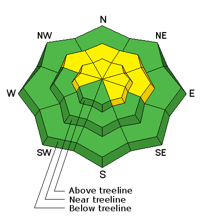
bottom line A MODERATE avalanche danger exists in mid and upper elevation terrain, particularly in the wind zone, above treeline. Human triggered dry snow avalanches are POSSIBLE on all steep wind drifted slopes, especially those facing the north half of the compass, and particularly those with an easterly component to their aspect. In either case- an avalanche triggered today can quickly get out of hand if it breaks into weak layers of snow, now buried deeper in our snowpack. Most south facing terrain and lower elevation wind sheltered terrain offers LOW avalanche danger.
|
 |
special announcement We couldn't get out on the snow without the great support from Polaris, Ski Doo, and Arctic Cat as well as KTM and Timbersled. Our local dealers make it happen. Tri-City Performance, Weller Recreation, Northstar's Ultimate Outdoors, Big Pine and Morgan Valley Polaris. We use these machines to monitor the snowpack across the state of Utah. We also use these machines to teach life-saving classes. |
 |
current conditions High clouds stream into the area ahead of an active weather pattern slated to homestead over the region through the weekend. Southerly winds blow in the mid to upper 20's and temperatures are in the teens and low 20's. Yesterday's sun didn't totally bake all south facing terrain, but it definately helped shrink-wrap the snow and the surface is crusted this morning. On the other side of the compass the snow is cold, light and spongy. delivering some of the best riding conditions all year.
Above are 24 hour temperatures and snow depth near Trial Lake along with winds and temperatures from Currant Creek Peak. More remote Uinta weather stations are found here
Ted found creamy snow, good stability, and rather good coverage in Whitney Basin yesterday. More on his travels along with a great body of recent trip reports, observations, and snow data here. |
 |
recent activity
Other than manageable sluffing on steep slopes like in the image above, the snowpack adjusted nicely to our recent round of snow. (Sroggin image) A list of recent avalanches is found here. |
| type | aspect/elevation | characteristics |
|---|

|

|
LIKELIHOOD
 LIKELY
UNLIKELY
SIZE
 LARGE
SMALL
TREND
 INCREASING DANGER
SAME
DECREASING DANGER
|
|
description
There are miles of terrain you can ride today where avalanche conditions remain straight-forward, predictable, and manageble. However, if your travels take you into steep, rocky terrain or slopes that have either remained shallow from lack of snow or thin due to repeat avalanches, you're gonna have to be on your game... and here's why. First- every significant storm that's rolled through the region this season has reactivated our dormant weak layers, especially where the pack remains thin and weak. Second- not every steep slope we ride with these characteristics is gonna avalanche and that gives us a false sense of snow stability. Third and most important- slopes with these characteristics may be reactive to our additional weight and have the possibility to break deeper than you might expect. So... a bit to digest, but when I'm uncertain about sketchy avalanche dragons, I simply avoid where they live. Steep, mid and upper elevation terrain facing the north half of the compass are prime suspects as are slopes that already avalanched this season. So here's the exit strategy... if you're looking for soft snow and safe riding, simply tone down your slope angles and avoid terrain with steep slopes hanging above you.
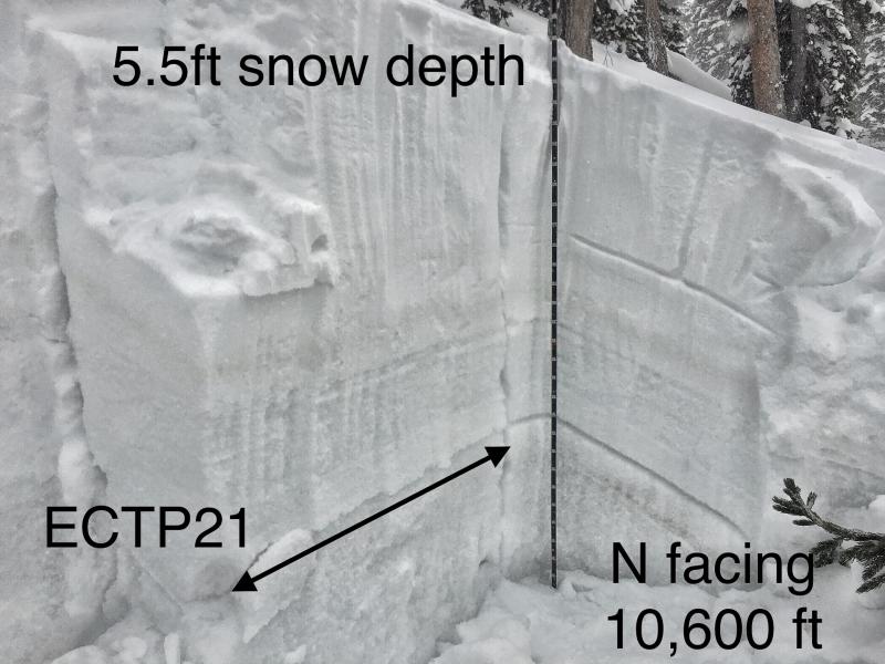
ECT - Extended column test P - means it propagated a crack across the whole column, a bad sign 21 - It took 21 taps for it to happen. The number of taps is far far less important compared to whether it propagated a crack or not. |
 |
weather
Today we can expect mostly cloudy skies, temperatures rising into the 40's, and light snow showers developing late in the day as a warm southwest flow draws subtropical moisture into the area beginning today. Southwest winds blow in the 20's and 30's. Some light rain and snow showers are possible today, but precipitation becomes more widespread tomorrow into Friday as a storm system moves through. Snow levels will be in the 9000-10000 foot range during the day Thursday with the best precipitation before lowering to around 6000 feet Friday morning with the arrival of a cold front. Unsettled weather continues through the weekend. |
| general announcements The information in this advisory expires 24 hours after the date and time posted, but will be updated by 7:00 AM Thursday March 22nd, 2018. If you're getting out and about, please let me know what you're seeing especially if you see or trigger and avalanche. I can be reached at [email protected] or 801-231-2170 It's also a good time to set up one of our very popular avalanche awareness classes. Reach out to me and I'll make it happen. This information does not apply to developed ski areas or highways where avalanche control is normally done. This advisory is from the U.S.D.A. Forest Service, which is solely responsible for its content. This advisory describes general avalanche conditions and local variations always occur. |