25th Annual Black Diamond Fall Fundraising Party
Thursday, September 13; 6:00-10:00 PM; Black Diamond Parking Lot
25th Annual Black Diamond Fall Fundraising Party
Thursday, September 13; 6:00-10:00 PM; Black Diamond Parking Lot
| Advisory: Uintas Area Mountains | Issued by Craig Gordon for Tuesday - March 28, 2017 - 3:25am |
|---|


|
bottom line In the wind zone at and above treeline, a CONSIDERABLE avalanche danger exists and human triggered avalanches are LIKELY on steep, wind drifted slopes. While not widespread, pockets of MODERATE avalanche danger are found at mid elevations and human triggered avalanches are POSSIBLE on steep slopes with recent deposits of wind drifted snow. Wind sheltered terrain offers generally LOW avalanche danger.
|
 |
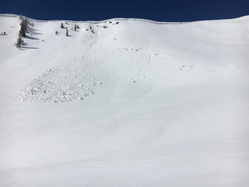
current conditions Wow... yesterday's drenching valley rain translated to a nice shot o' snow for the eastern front. The North Slope stacked up 10"-12" of medium snow, whilst the south half of the range received half that amount. The big winner though is terrain on the east side of the range, right around Lily Lake which clocks in closer to 16" of new snow. Under mostly cloudy skies, temperatures are in the teens and low 30's. Unfortunately, north and northeast winds bumped into the 30's last night and I bet some of our big open bowls are a bit wind damaged. The good news is you can lose a little elevation, tuck into wind sheltered terrain and on a go-anywhere base, you'll be rewarded with amazing spring riding conditions.
Above... 24 hour winds from Lofty Lake Peak (11,186') and the Trail Lake snotel site (9,992') Real time temperatures, snowfall and wind for the western Uintas are found here. Snowpack observations and trip reports are found here. |
 |
recent activity The new snow was very sensitive by days end yesterday with avalanches predictably failing within the new storm snow, but breaking wider than you might expect and packing a bit of heat. A full list of Uinta avalanche activity is found here. |
| type | aspect/elevation | characteristics |
|---|

|

|
LIKELIHOOD
 LIKELY
UNLIKELY
SIZE
 LARGE
SMALL
TREND
 INCREASING DANGER
SAME
DECREASING DANGER
|
|
description
Winds were all over the place yesterday as the storm developed and I noticed dense drifts forming in some unusual, terrain driven locations. With winds shifting to the northeast overnight, slopes we usually see stripped of snow will be fat this morning, especially terrain with an westerly component to its aspect. While yesterday's fresh snow predictably broke at my skis, it was suprisingly sensitive to my additional weight. Since the storm came in waves, there were a few density inversions within the storm snow. To a large degree I think these nuances settled out over night and that's yesterdays news. Happening now, is a bump in the winds and I bet there's a whole new round of slabs waiting for a trigger like us to come along and tip the scales. In addition, today's avalanches might break a little deeper and wider than you might expect. The good news is... we've got a solid, well-behaved snowpack, today's avalanche hazard is straight-forward, and this is an easy avalanche problem to deal with. Lose a little elevation, you lose the problem, and you get a great day of riding in to boot... not a bad way roll. |
| type | aspect/elevation | characteristics |
|---|

|
|
LIKELIHOOD
LIKELY
UNLIKELY
SIZE
 LARGE
SMALL
TREND
 INCREASING DANGER
SAME
DECREASING DANGER
|
|
description
|
 |
weather Yesterday's storm is moving to the east and in it's wake skies begin to clear as the day progresses. Northerly winds are gonna be a nuisance, blowing in the 30's and 40's along the high ridges. Temperatures climb into the low 30's with overnight lows dipping into the teens under clearing skies. A warming trend is in store through midweek under a building ridge. The next storm system slated for late in the week might be diving south, which translates to more blow than snow. We'll have a better feel for that in the next day or two. |
| general announcements Remember your information can save lives. If you see anything we should know about, please participate in the creation of our own community avalanche advisory by submitting snow and avalanche conditions. You can call me directly at 801-231-2170, email [email protected] The information in this advisory is from the US Forest Service which is solely responsible for its content. This advisory describes general avalanche conditions and local variations always occur. The information in this advisory expires 24 hours after the date and time posted, but will be updated by 7:00 AM on Wednesday March 29th. |