25th Annual Black Diamond Fall Fundraising Party
Thursday, September 13; 6:00-10:00 PM; Black Diamond Parking Lot
25th Annual Black Diamond Fall Fundraising Party
Thursday, September 13; 6:00-10:00 PM; Black Diamond Parking Lot
| Advisory: Uintas Area Mountains | Issued by Craig Gordon for Thursday - March 2, 2017 - 3:38am |
|---|


|
bottom line While not widespread and making up a small portion of the terrain available to ride in today, at and above treeline in the wind zone, you'll find pockets of CONSIDERABLE avalanche danger. Human triggered avalanches are LIKELY on steep wind drifted slopes, especially those with an easterly component to their aspect. A MODERATE avalanche danger is found in mid elevation terrain and human triggered avalanches are possible on steep slopes with recent deposits of wind drifted snow. Wind sheltered slopes in mid and lower elevations offer LOW avalanche danger.
|
 |
current conditions Skies finally cleared late yesterday and temperatures dipped into the single digits overnight, and that's where they register this morning. Northwest winds are blowing in the 20's along the high ridges. Monday night's storm snow has settled to about 2' in depth. I completely blew yesterday's weather forecast, but today I guarantee... sunny skies, deep cold pow, and a go anywhere base. Yep, it's the kind of riding and turning conditions that make our license plate famous. Real time wind, snow, and temperatures for the Uinta's are found here Snowpack observations and trip reports are found here. |
 |
recent activity
Above... I found this pocket on a steep, wind-loaded, ESE aspect in the wind zone which broke during Tuesday night's spike in winds. And below... Dave Kikkert and crew thumped on a wind-loaded NE aspect and got a localized pocket to break out, but the slab quickly ran out of connectivity.
|
| type | aspect/elevation | characteristics |
|---|

|

|
LIKELIHOOD
 LIKELY
UNLIKELY
SIZE
 LARGE
SMALL
TREND
 INCREASING DANGER
SAME
DECREASING DANGER
|
|
description
The good news is... recent tests and snowpack observations reveal a strong snowpack that's comfortable in it's own skin. Most avalanches we've seen in the past few days are pockety and failing within the storm snow. I'd say we're trending towards a more stable and predictable snowpack, but I don't think we've got the full on green light just yet. The Uinta's are a big place and I bet there's still a wind drift or two that'll react to our additional weight today. Confined to steep, leeward slopes in the wind zone, cross-loaded chutes, gullies, or bowl features are likely suspect terrain. Any avalanche triggered in terrain with these characteristics may be a little bigger than you bargained for. But wait... there's more good news. Lose a little elevation, you lose the problem, and you're rewarded with epic riding conditions.
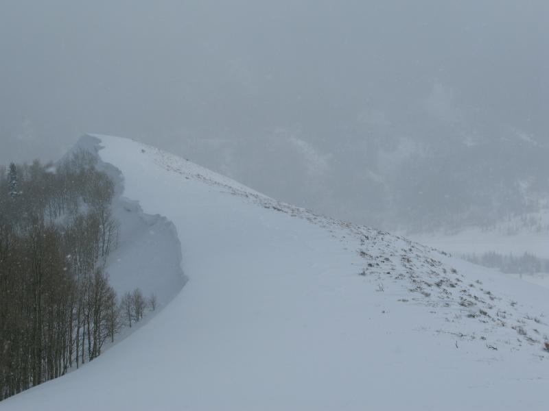
This is how wind drifts and cornices form. Pretty easy to see by the image above that winds have been blowing right to left, stripping the windward slopes down to sage and loading the leeward slopes, forming a slab that'll be reactive to our additioanl weight. |
| type | aspect/elevation | characteristics |
|---|

|

|
LIKELIHOOD
 LIKELY
UNLIKELY
SIZE
 LARGE
SMALL
TREND
INCREASING DANGER
SAME
DECREASING DANGER
|
|
description
Corni... they're ridiculous this year, stretch for miles along the ridges, and are breaking back further than you might expect. You definitely want to give these unpredictable boxcar monsters the respect they deserve. |
 |
weather A ridge of high pressure builds, giving us warm, dry weather for Thursday and Friday with temperatures rising into the 30's. Northwest winds blow in 20's with a few gust near 40 mph along the high peaks. Southwest winds ramp up Friday afternoon into Sunday, ahead of a cold front slated to arrive late Sunday. We should see a good shot of snow developing Sunday night into Monday. |
| general announcements Remember your information can save lives. If you see anything we should know about, please participate in the creation of our own community avalanche advisory by submitting snow and avalanche conditions. You can call me directly at 801-231-2170, email [email protected] The information in this advisory is from the US Forest Service which is solely responsible for its content. This advisory describes general avalanche conditions and local variations always occur. The information in this advisory expires 24 hours after the date and time posted, but will be updated by 7:00 AM on Friday March 3rd. |