25th Annual Black Diamond Fall Fundraising Party
Thursday, September 13; 6:00-10:00 PM; Black Diamond Parking Lot
25th Annual Black Diamond Fall Fundraising Party
Thursday, September 13; 6:00-10:00 PM; Black Diamond Parking Lot
| Advisory: Moab Area Mountains | Issued by Eric Trenbeath for Sunday - December 18, 2016 - 6:02am |
|---|


|
bottom line The avalanche danger remains CONSIDERABLE on all aspects in wind exposed, upper elevation terrain that has recent deposits of wind drifted snow. There also remains a CONSIDERABLE danger for triggering a deep and dangerous persistent slab avalanche on slopes steeper than 30 degrees, that face NW-E-SE at mid and upper elevations. Elsewhere the avalanche danger is MODERATE. Backcountry travelers are advised to stick to lower angle terrain today.
|
 |
special announcement Grand County Road crew plowed the road to Geyser Pass Trailhead yesterday. Thanks to them for getting up on the weekend! |
 |
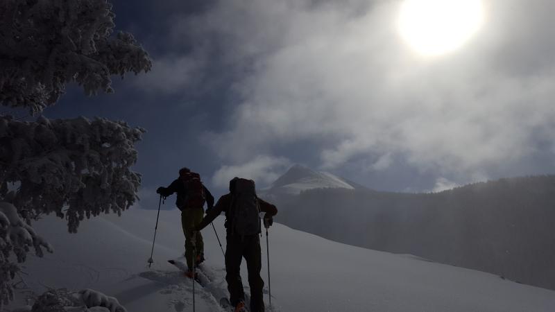
current conditions Today will be a glorious winter day in the mountains with sunshine, cold temperatures and fresh snow. It will also be one of those days where you may be tempted to ride on slopes that you shouldn't as the beautiful conditions conspire to mask the underlying avalanche danger. Reports of widespread collapsing and whumping, which are sure signs of snow instability, came in from yesterday. Thanks to Travis Nauman for this detailed report. All told, the mountains received 12-16" of snow between Thursday night and Saturday morning with around 2" of water. The first wave of snow came in heavy and wet under 30-50 mph southwesterly winds. This created dense, upside down snow conditions, and heavily wind loaded areas alternating with zones of scour. The second round of snow came in Friday night totaling about 6" of much lower density snow under light to moderate northwesterly winds. The lighter snow greatly improved riding conditions, but also hid the havoc that lies underneath. Temperatures are in the single digits this morning and a cold, northwesterly breeze is blowing in the 10-15 mph range. High temperatures today will be in the low 20's at 10,000'. Storm totals and temperature in Gold Basin.(10,000') Wind, temperature and humidity on Pre Laurel Peak.(11,700') Snow totals, temperature and snow/water equivalent at the Geyser Pass Trailhead.(9600')
Travis Nauman shot this pic of backcountry enthusiasts ascending into the winter wonderland yesterday. |
| type | aspect/elevation | characteristics |
|---|

|

|
LIKELIHOOD
 LIKELY
UNLIKELY
SIZE
 LARGE
SMALL
TREND
 INCREASING DANGER
SAME
DECREASING DANGER
|
|
description
The recent load of snow has been just enough to tip the scales and stress buried weak, faceted layers in our snowpack. The following video shot on Friday, December 16, illustrates the tenuosness of the situation. Add a wind slab on top of this and you will have a very deep and dangerous avalanche. Stay off of and out from under steep slopes that have a NW-E-SE aspect. |
| type | aspect/elevation | characteristics |
|---|

|
|
LIKELIHOOD
LIKELY
UNLIKELY
SIZE
 LARGE
SMALL
TREND
 INCREASING DANGER
SAME
DECREASING DANGER
|
|
description
Strong gusty winds, and dense heavy snow have combined to make the perfect recipe for widespread wind slab development. They'll be a bit more stubborn today, but once triggered they have the potential to step down into a deeper, persistent weak layer causing a deeper and more dangerous avalanche. Present on all aspects above tree line, they are recognizable by their smooth, rounded, appearance. Areas of wind drifted snow should be avoided on slopes steeper than 30 degrees. |
 |
weather Today Sunny, with a high near 22. Wind chill values as low as -15. North northwest wind 5 to 10 mph. Tonight Mostly clear, with a low around 7. North wind around 5 mph becoming south in the evening. Monday Sunny, with a high near 21. Northwest wind 5 to 10 mph becoming west southwest in the afternoon. Monday Night Partly cloudy, with a low around 12. West wind around 10 mph. Tuesday Mostly sunny, with a high near 28. West southwest wind 10 to 15 mph. Tuesday Night Mostly cloudy, with a low around 13. Wednesday Sunny, with a high near 19. |
| general announcements Groomers will be up today packing in the fresh snow for cross country skiing. |