25th Annual Black Diamond Fall Fundraising Party
Thursday, September 13; 6:00-10:00 PM; Black Diamond Parking Lot
25th Annual Black Diamond Fall Fundraising Party
Thursday, September 13; 6:00-10:00 PM; Black Diamond Parking Lot
| Advisory: Logan Area Mountains | Issued by Toby Weed for Wednesday - March 28, 2018 - 7:15am |
|---|


|
bottom line Heightened avalanche conditions and MODERATE danger exist in drifted terrain at upper elevations where you could trigger cornice falls, wind slab avalanches and sluffs. Cloud cover and a breeze may help, but loose wet avalanches entraining fresh snow will be likely with seasonal daytime warmth.
Paige will update this advisory by 7:30 Friday morning, 3/30/18.
|
 |
special announcement The UAC Marketplace is still open. Our online marketplace still has deals on skis, packs, airbag packs, beacons, snowshoes, soft goods and much more. |
 |
current conditions Sun affected the nice powder on all but north facing slopes yesterday, and we'll find crusty conditions in most areas this morning. Westerly winds picked up late yesterday and were sustained overnight, drifting soft snow at upper elevations. Triggered cornice falls and wind slab avalanches are possible today, and seasonal warming will create rising danger of loose wet avalanches entraining fresh snow.
Clouds finally cleared off the Wellsville Range, and we could see a few nice natural avalanches, likely from late in the warm, rainy, and windy storm, (3/23 or 3/24) |
 |
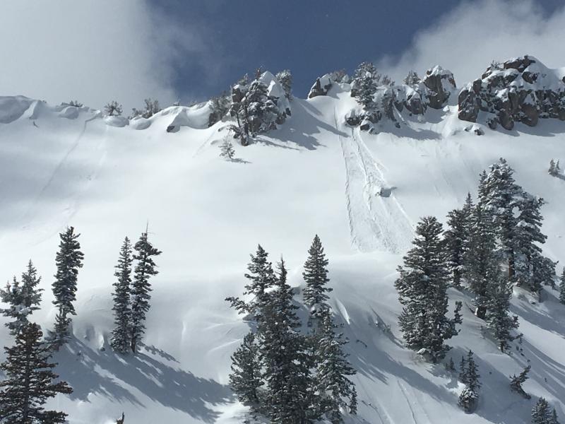
recent activity
A couple natural avalanches in steep terrain near Naomi Peak (viewed on 3/26). A small cornice-fall triggered wind slab (left) and dry sluffs entraining powder snow. |
| type | aspect/elevation | characteristics |
|---|

|

|
LIKELIHOOD
 LIKELY
UNLIKELY
SIZE
 LARGE
SMALL
TREND
 INCREASING DANGER
SAME
DECREASING DANGER
|
|
description
Human triggered wind slab avalanches and cornice falls are possible in drifted terrain at upper elevations.
Triggered loose dry avalanches or sluffs were common on very steep upper elevation slopes yesterday in the Tony Grove Area |
| type | aspect/elevation | characteristics |
|---|

|

|
LIKELIHOOD
LIKELY
UNLIKELY
SIZE
LARGE
SMALL
TREND
 INCREASING DANGER
SAME
DECREASING DANGER
|
|
description
Clouds and a breeze should help keep things cool, but seasonal warming will create increasing danger of loose wet avalanches entraining saturated fresh snow. |
| type | aspect/elevation | characteristics |
|---|

|

|
LIKELIHOOD
 LIKELY
UNLIKELY
SIZE
 LARGE
SMALL
TREND
INCREASING DANGER
SAME
DECREASING DANGER
|
|
description
Dangerous deep or persistent slab avalanches are unlikely yet still possible in isolated drifted areas with shallow weak snow. I've found suspect conditions recently on steep forested slopes, in shallow rocky terrain, and in outlying, wilderness, and rarely visited areas. The danger of large avalanches failing on old snow will rise with as day and night temperatures rise this spring. |
 |
weather The broad area of high pressure aloft across the western states will generate a warming trend across Utah through the end of the week.
|
| general announcements We have lift tickets for Snowbasin and Powder Mountain remaining. The tickets are discounted an additional 20%. Details and order information here. All proceeds from these go towards paying for avalanche forecasting and education! Episode 7 of the UAC Podcast "Mastery and False Mastery - An Interview with 'Big' Don Sharaf" is live. With a snow career spanning over 30 years, Don has enough mileage in the mountains to have learned a thing or two, including the profound value of humility when staring into the face of the dragon. Listen in on our conversation about the idea of mastery and if such a thing can exist in the avalanche world. Check it out on the UAC blog, ITunes, Stitcher, or wherever you get your podcasts. The UAC has new support programs with Outdoor Research and Darn Tough. Support the UAC through your daily shopping. When you shop at Smith's, or online at Outdoor Research, REI, Backcountry.com, Darn Tough, Patagonia, NRS, Amazon, eBay a portion of your purchase will be donated to the FUAC. See our Donate Page for more details on how you can support the UAC when you shop. Benefit the Utah Avalanche Center when you buy or sell on eBay - set the Utah Avalanche Center as a favorite non-profit in your eBay account here and click on eBay gives when you buy or sell. You can choose to have your seller fees donated to the UAC, which doesn't cost you a penny Check it out on ITunes, Stitcher, the UAC blog, or wherever you get your podcasts. Now is a great time to practice companion rescue techniques with your backcountry partners. Here's our rescue practice video. EMAIL ADVISORY: If you would like to get the daily advisory by email you will need to subscribe here. Remember your information can save lives. If you see anything we should know about, please help us out by submitting snow and avalanche observations. You can also call us at 801-524-5304, email by clicking HERE, or include #utavy in your Instagram. This advisory is from the U.S.D.A. Forest Service, which is solely responsible for its content. This advisory describes general avalanche conditions and local variations always occur. |