Observation: Silver Fork

Observation Date
3/14/2024
Observer Name
Kelly/Kelly
Region
Salt Lake » Big Cottonwood Canyon » Silver Fork
Location Name or Route
Silver Fork
Weather
Sky
Overcast
Precipitation
Light Snowfall
Wind Direction
North
Wind Speed
Light
Weather Comments
Cloud deck was at 9800'. Above 9800' there was thick fog with riming on the trees. We did not note any riming on the snow surface. Winds were light and sporadic blowing from the north, with gusts picking up from the north-northwest. Air temperature was in the high teens °F.
Snow Characteristics
New Snow Depth
14"
New Snow Density
Medium
Snow Surface Conditions
Powder
Snow Characteristics Comments
In sheltered areas there was 14" of settled snow. On the windward side of the ridges there was a bit less snow where the wind had been slowly stripping it. On solar aspects there was an old melt-freeze crust that you could still feel on steeper slopes underneath the newest snow.
Avalanche Problem #1
Problem
Wind Drifted Snow
Trend
Same
Problem #1 Comments
We observed some wind-loading occuring on southerly facing slopes where the north winds were blowing and transporting snow. There were cornices that were starting to get stripped back in the other direction as the winds shifted. We observed some old hard wind slabs on north-west facing slopes above 10,400' that did have a slightly hollow feel- but we observed no cracking or collapsing on these wind slabs. With the change in wind direction this is something to keep an eye out for as there may be wind-drifts near ridgelines on all aspects at higher elevations.
Avalanche Problem #2
Problem
New Snow
Trend
Decreasing Danger
Problem #2 Comments
We were able to initiate one new snow avalanche that was approximately 10" deep running on a density change within the newest storm snow 2" above melt-freeze crust on a steep southeast facing slope at 10,200'. This avalanche was skier triggered intentionally and was 10'-12' wide x 10" deep running approximately 50' into the trees below. This broke out at our skis and did not break above us.
Snow Profile
Aspect
Northeast
Elevation
9,800'
Slope Angle
34°
Comments
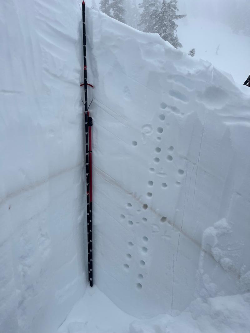
The layer of greatest concern was 18"(45cm) from the surface breaking underneath a pencil hard crust. We got this result without propagation one time and the second test gave us an extended column test with no results. What was noteable was that we had a layer that was 3'(95cm) from the surface where we were able to get a clean shear on small grained rounding facets after our extended column tests. This layer was not a concern on the slope we tested. The dirt layer from March 2nd was clearly visible and there were rounding facets in this dirt layer but no propagation results. Overall in this location we found a stable snowpack with the layers of greatest concern associated with the newest snow from yesterday and forecasted increased wind speeds.
We got out before the forecasted winds increased in speed and found an overall moderate avalanche danger. We avoided steep hollow wind drifted snow near the ridges and travelled on all aspects from 8,500'-10'400'. Lower angle terrain on the solar aspects was still soft and north facing terrain out of the wind-zone was good skiing.
Today's Observed Danger Rating
Moderate
Tomorrows Estimated Danger Rating
None
Coordinates