


Forecast for the Uintas Area Mountains

Issued by Craig Gordon on
Wednesday morning, January 1, 2020
Wednesday morning, January 1, 2020
HEADS UP... expect a rising avalanche danger throughout the day as we ring in the New Year.
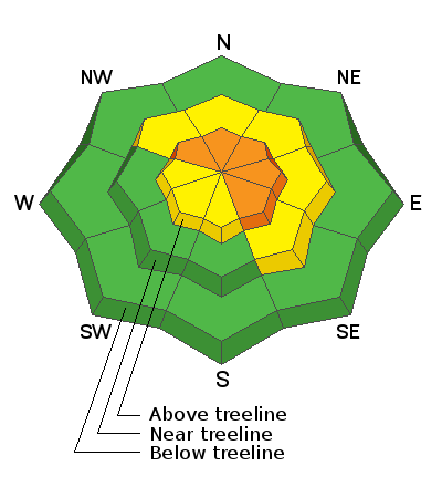
At upper elevations in the wind zone, on all aspects of the compass, a CONSIDERABLE avalanche danger exists. Human triggered avalanches are PROBABLE, especially on steep, wind drifted slopes, and particularly in terrain with an easterly component to its aspect. Once initiated, a fresh wind drift may break on weak snow near the ground, creating a larger avalanche than you might expect. The danger may rise to HIGH by days end as the storm intensifies.
Strong winds will drift fresh snow into mid elevation terrain as well, creating a MODERATE avalanche danger. Human triggered avalanches are POSSIBLE on steep, wind drifted leeward slopes.
Today's exit strategy-
Wind sheltered, low elevation terrain and big open meadows with no steep slopes above or adjacent to where you're riding generally offers LOW avalanche danger and human triggered avalanches are unlikely.
Low
Moderate
Considerable
High
Extreme
Learn how to read the forecast here
 Special Announcements
As the sun sets on 2019, our team at the UAC wishes all of you a happy, and most importantly, a safe New Year!
We look forward to seeing y'all out on the snow!
 Weather and Snow
Currently-
Under mostly cloudy skies, light snow falls and temperatures register in the mid 20's. West and southwest winds blow at a reasonable clip, clocking in at 20-30 mph along the high peaks. The range has excellent early season coverage with total snow depths averaging close to 4' of settled snow.
Uinta weather network info is found here. Simply click on the Western Uinta tab.
For today-
 Recent Avalanches
Other than loose snow sluffing on steep slopes, no significant new avalanche activity to report.
Big thanks to Bo and Zinnia for helping with Currant Creek weather station maintenance. Their take on the state of the snowpack as well as their trip report is found here.
To view trip reports and recent avalanche activity, simply click here.

Avalanche Problem #1
Wind Drifted Snow
Type
Location

Likelihood
Size
Description
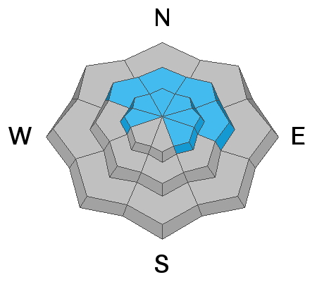
Strong winds and heavy snow will change the landscape, whipping snow into sensitive drifts reactive to our additional weight. Winds are forecast to be all over the place, so expect fresh slabs along the leeward side of upper elevation ridges and around terrain features like chutes and gullies. Of course, your best bet for avoidance is to simply steer clear of any fat, rounded piece of snow, especially if it sounds hollow like a drum. In addition, look for shooting cracks in the snow which is a sure sign of unstable conditions.
Avalanche Problem #2
Persistent Weak Layer
Type
Location
Likelihood
Size
Description

All the avy pros I talk with have the same overall feeling about our current snowpack setup.... we're encouraged by what we're seeing. The pack is slowly gaining strength and it's got body. It's not just a pile of weak, lifeless, sugary snow... and that's good news. Now, the snowpack puts our theories to test and we'll see how our problem child, a persistent weak layer near the ground, reacts to today's storm. Remember- the issue with persistent weaknesses in the snowpack is they can take long periods of time to heal. And more disconcerting is that you can ride some slopes and be good to go, while others just wait for us to roll along and knock the legs out from underneath. And even more sketchy is ... once initiated, avalanches have a distinct possibility of breaking deeper and wider than I might expect. You can clearly see the problematic structure in Bo's pit profile above.
Personally, I don't entirely trust anything in the snowpack I can't manage, so I'm going to continue avoiding terrain that harbors questionable snowpack structure. Of course the usual suspects come to mind... steep, rocky, upper elevation slopes facing the north half of the compass is bulls-eye terrain and should be considered suspect. With all the great coverage across the range and so many other riding options, there's no reason to roll the dice or pull on the dogs tail.
General Announcements
The information in this forecast expires in 24 hours, but will be updated by 7:00 AM Wednesday Jan. 2nd.
This forecast is updated daily by 7:00 AM.
In the mean-time, if you see or trigger an avalanche or just wanna let me know what you're seeing you can reach me directly at 801-231-2170
It'll be a minute or two before we're riding, but while you're waiting....
This is a great time of year to schedule one of our free avy awareness presentations.
You can email me directly [email protected]
The information in this forecast is from the US Forest Service which is solely responsible for its content.