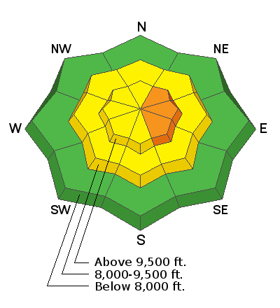
Forecast for the Skyline Area Mountains

Issued by Brett Kobernik on
Wednesday morning, January 1, 2020
Wednesday morning, January 1, 2020
The avalanche danger will be on the rise today with strong wind and new snow. Avoid steep upper elevation slopes where the wind is drifting snow. It is likely that we will see natural avalanches along the more east facing terrain where the fresh drifts are forming. The avalanche danger may reach CONSIDERABLE later today.

Low
Moderate
Considerable
High
Extreme
Learn how to read the forecast here
 Weather and Snow
We have a storm moving in today. We may see some snow this morning but the majority will come mid day and especially tonight. Snow showers look like they'll linger through Thursday. I'm expecting 8 to 12 inches of snow by Thursday night. Northwest wind looks like it's going to be pretty strong through this storm. Mountain high temperatures will be in the low 20s today and upper teens on Thursday.
Avalanche Problem #1
Wind Drifted Snow
Type
Location

Likelihood
Size
Description
You are definitely going to want to avoid the steep terrain in the high elevations today as wind and new snow form fresh drifts. I'm expecting that some of these will release naturally and that many will be sensitive to the weight of a person. Aside from being on steep slopes, you'll also want to avoid being below them as well.
Additional Information
This forecast is from the U.S. Forest Service, which is solely responsible for its content. This forecast describes general avalanche conditions and local variations always occur.


