


Forecast for the Uintas Area Mountains

Issued by Craig Gordon on
Saturday morning, April 4, 2020
Saturday morning, April 4, 2020
In an overall sea of green, at and above treeline in the wind zone, pockets of MODERATE avalanche danger exist on wind drifted slopes. Human triggered avalanches are POSSIBLE on steep, leeward slopes facing the north half of the compass, particularly those with an easterly component to its aspect. Any avalanche triggered is gonna pack a punch and could easily ruin your day.
Your risk reducing exit strategy is this- good riding with more predictable avalanche danger is found with some loss of elevation. Wind sheltered mid and low elevation terrain offers generally LOW avalanche danger.
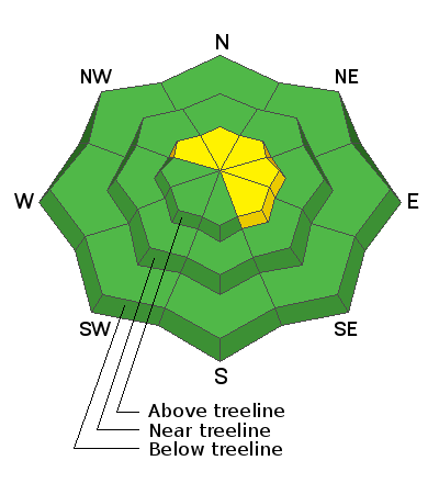
Low
Moderate
Considerable
High
Extreme
Learn how to read the forecast here
 Special Announcements
Spring Awareness Campaign - Help us save lives through avalanche forecasts and education. Consider making a donation before April 8th.
January 5, 2019 - Read this collection of 6 stories and a podcast about that day with a low avalanche danger, 8 skier-triggered avalanches, four catch and carries, a partial and critical burial, and a trip to the emergency room.
We are sad to share the news of two recent avalanche fatalities:
On Wednesday, Trace Carrillo died in an avalanche on Taylor Mountain near Teton Pass. Trace was formerly an intern with the UAC and more recently a wilderness ranger with the Forest Service. Article here. Preliminary report here.
On Friday, Rob Kincaid died in an avalanche just north of Palisades Reservoir near the ID/WY stateline. Rob was well known by many snowmobilers as an athlete for Arctic Cat and veteran of many snowmobile competitions. Article here. Preliminary report here.
More details should be available soon about these tragic events but initial reports are that both men were wearing avalanche transceivers that were not turned on.
January 5, 2019 - Read this collection of 6 stories and a podcast about that day with a low avalanche danger, 8 skier-triggered avalanches, four catch and carries, a partial and critical burial, and a trip to the emergency room.
 Weather and Snow
Currently-
Under clear skies and a bright, beautiful moon, warm, high pressure strengthened overnight. Temperatures have risen by about 15 degrees in some locations since yesterday at this time and currently register in the mid teens and low to mid 20's. Southwest winds blow in the 30's along the high peaks. Riding and turning conditions are a bit of a mixed bag and if you're looking for soft settled snow, wind sheltered, upper elevation terrain is the the only game in town.
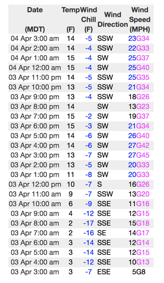
Lofty Lake Peak (11,186') showing yesterday's brief sunset respite, with southwest winds increasing late last night and continue this morning.
More Uinta weather network info is found here. Simply click on the Western Uinta tab.
For today-
On tap for today... mostly sunny skies with temperatures climbing into the mid and upper 30's. Southwest winds are gonna be a nuisance along the high peaks, blowing in the 30's with higher gusts possible.
Futurecast-
Unsettled weather sets the stage for the next few days with a weak meandering storm clipping the region Sunday.
 Recent Avalanches
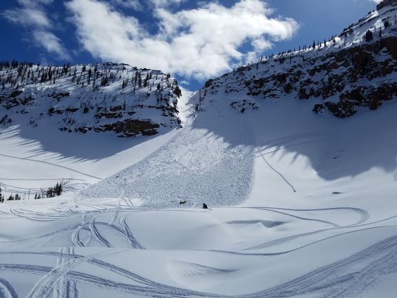
Breaking 3' deep and a football field wide, the avalanche in the image above was triggered yesterday on the steep, heavily wind loaded, northwest facing bowl of Notch Mountain. As noted by the rider.... "I was the third snowmobiler to climb the mountain and I triggered the slide. Avalanche airbag kept my head above the snow." More details found here.
To view additional trip reports and recent avalanche activity, simply click here.

Avalanche Problem #1
Wind Drifted Snow
Type
Location

Likelihood
Size
Description
The Uinta's are amazing right now... fat, white and filled in. As a matter of fact, we've got a solid snowpack with a go anywhere base, which enables us to get onto big slopes and tag complex terrain. But, as you know, the Uinta's are a big range. And... I bet if you were looking to trigger an avalanche today you could find one. Yesterday's slide near Notch Mountain not only illustrates the type of terrain we love to ride in the spring, it's also the type of terrain where we could trigger a slide today.
Big picture- the most likely suspect terrain we need to carefully evaluate are steep, leeward slopes in the wind zone at and above treeline. Generally easy to detect by their fat, rounded appearance, recent wind drifts might be slightly more disguised by the midweek storm snow, and therefore a bit more elusive to identify today. So, the key to riding safely today is... be flexible with your travels plans and adjust objectives if you're starting to see or feel obvious clues to unstable snow like shooting cracks, sudden collapses, or avalanches with the same terrain characteristics like the slopes you wanna ride. In addition, think about the consequences of triggering a slide, especially if you're getting into steep, technical terrain.
Snow has an amazing memory... people, not so much.
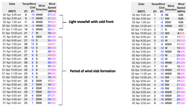
Above a 48 hour data dump for Windy Peak (10,662') illustrating midweek winds along the high peaks, helping to explain how, where, and why drifting occurred.
Additional Information
A little climatology food for thought... if you're into that sorta thing.
Information on outdoor recreation - The State of Utah created this webpage with information about recreating on both state and federal public lands during the current health crisis.
Skiing and riding at closed ski resorts - Some resorts allow access now, and some do not. Please check HERE for the latest info on ski area access.
New to the backcountry (including riding at closed resorts) - Watch the award-winning, 15 minute Know Before You Go video, or take the 5-part, free online-learning series.
General Announcements
The information in this forecast expires in 24 hours, but will be updated by 7:00 AM Sunday Apr. 5th.
This forecast is updated daily by 7:00 AM.
In the mean-time, if you see or trigger an avalanche or just wanna let me know what you're seeing you can reach me directly at 801-231-2170
The information in this forecast is from the US Forest Service which is solely responsible for its content.