March Kicks Off Our Spring Campaign- Donate Now to Support Forecasting

Forecast for the Uintas Area Mountains

Craig Gordon
Issued by Craig Gordon on
Friday morning, April 3, 2020
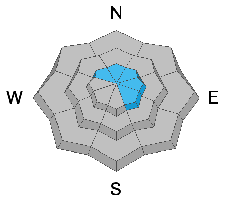
In an overall sea of green, at and above treeline in the wind zone, pockets of MODERATE avalanche danger exist on wind drifted slopes. Human triggered avalanches are POSSIBLE on steep, leeward slopes facing the north half of the compass, particularly those with an easterly component to its aspect.
Your risk reducing exit strategy is this- good riding with more predictable avalanche danger is found with some loss of elevation. Wind sheltered mid and low elevation terrain offers generally LOW avalanche danger.
Low
Moderate
Considerable
High
Extreme
Learn how to read the forecast here
Special Announcements
Spring Awareness Campaign - Help us save lives through avalanche forecasts and education. Consider making a donation before April 8th.

Information on outdoor recreation - The State of Utah created this webpage with information about recreating on both state and federal public lands during the current health crisis.

January 5, 2019 - Read this collection of 6 stories and a podcast about that day with a low avalanche danger, 8 skier triggered avalanches, four catch and carries... a partial and critical burial, and a trip to the emergency room.
Weather and Snow
Currently-
Yesterday's quick hitting storm delivered a welcome refresher... 5" of light density snow brushing the peaks with a fresh coat of white paint. Skies cleared late yesterday, and of course temperatures dropped like a rock overnight, cratering into the single digits and near zero along the ridges. In addition, wind died significantly and there's hardly a whisper, blowing just 5-10 mph even along the high peaks. Riding and turning conditions are much improved and if you're looking for soft settled snow, wind sheltered, mid elevation terrain is the ticket.
More Uinta weather network info is found here. Simply click on the Western Uinta tab.
For today-
A stunning day is on tap with mostly sunny skies, light winds, and highs climbing into the mid 20's. Overnight lows dip into the teens.
Futurecast-
A warming trend is expected through Saturday and a weak storm clips the region Sunday. Perhaps some midweek storminess and unsettled weather brings a shallow reset to the range, though this wave might be a bit too far south to impact our zone.
Recent Avalanches
No significant avalanche activity to report from yesterday.
To view additional trip reports and recent avalanche activity, simply click here.
Ad
Avalanche Problem #1
Wind Drifted Snow
Type
Location
Likelihood
Size
Description
The Uinta's are amazing right now... fat, white and filled in. As a matter of fact, we've got a solid snowpack with a go anywhere base, which enables us to get onto big slopes and tag complex terrain. And yesterday's storm snow didn't do much to skew this balance. But, as you know, the Uinta's are a big range. And... I bet if you were looking to trigger a wind drift today you could find one. The most likely suspects are steep, leeward slopes in the wind zone at and above treeline. Generally easy to detect by their fat, rounded appearance, recent wind drifts might be slightly more disguised by yesterday's snowfall, and therefore a bit more elusive to identify today. So, the key to riding safely today is... be flexible with your travels plans and adjust objectives if you're starting to see or feel obvious clues to unstable snow like shooting cracks, sudden collapses, or avalanches with the same terrain characteristics like the slopes you wanna ride. In addition, think about the consequences of triggering a slide, especially if you're getting into steep, technical terrain.
Snow has an amazing memory... people, not so much.
Above a 48 hour data dump for Windy Peak (10,662') illustrating recent winds along the high peaks, helping to explain how, where, and why drifting occurred.
Additional Information
A little climotology food for thought... if you're into that sorta thing.

Skiing and riding at closed ski resorts - Some resorts allow access now, and some do not. Please check HERE for the latest info on ski area access.

New to the backcountry (including riding at closed resorts) - Watch the award-winning, 15 minute Know Before You Go video, or take the 5-part, free online-learning series.
General Announcements
The information in this forecast expires in 24 hours, but will be updated by 7:00 AM Saturday Apr. 4th.
This forecast is updated daily by 7:00 AM.
In the mean-time, if you see or trigger an avalanche or just wanna let me know what you're seeing you can reach me directly at 801-231-2170
The information in this forecast is from the US Forest Service which is solely responsible for its content.