Donate to Our Spring Campaign or Bid on our Spring Auction to Support Forecasting

Forecast for the Moab Area Mountains

Eric Trenbeath
Issued by Eric Trenbeath on
Tuesday morning, March 18, 2025
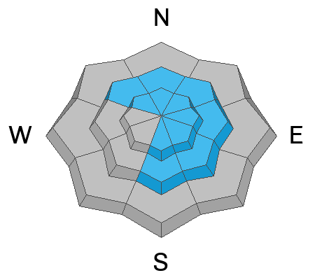
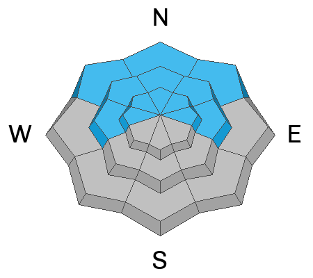
A MODERATE avalanche danger this morning could reach CONSIDERABLE later today on steep wind drifted slopes above treeline that face NW-N-NE-E. Periods of heavy snowfall and strong winds will create fresh slabs of wind drifted snow in these areas. With winds shifting to the northwest later today, we will likely see some drifting on SE-S aspects as well with the danger creeping down to near treeline. How deep and how widespread they are will depend on how much snow we get. Suspect steep slopes that have more than about 8 inches of newly deposited, wind drifted snow.
A MODERATE danger for human triggered avalanches 2-4 feet deep, failing on a buried persistent weak layer exists on steep slopes facing W-N-E. In these areas, deep and dangerous human triggered avalanches are possible with the highest likelihood found on steep northerly aspects right around treeline.
Low
Moderate
Considerable
High
Extreme
Learn how to read the forecast here
Special Announcements
The Utah Avalanche Center is excited to host Mountainfilm on Tour in Moab at Star Hall on 3/21 and 3/22. Click here for tickets and information.
Our Spring Campaign is in full swing, and there are two great ways to support forecasting, awareness, and education across Utah: Donate to our Spring Campaign, or Bid on items in our Spring Auction. Every dollar donated helps keep the backcountry community on top.
They will be working on the Loop Road today and it will be closed from 8:30-5:30 on the south end. Access to Geyser is from Castle Valley.
Geyser Pass Road: The lower half has mostly melted out while ruts and packed snow exist on the upper end. 4x4 required.
Grooming Conditions: The Gold Basin trail was last packed out on Sunday.
Weather and Snow
6 A.M. Snow and Weather Data
24 Hour Snow: 0" 72 Hour Snow: 6" Season Total Snow: 109" Depth at Gold Basin: 48"
Winds on Pre-Laurel Peak: N/A Temp: 11° F Percent of Normal (SWE): 91%
Weather
Pre Laurel Peak wind station and the Gold Basin storm stake are down as we install upgrades including a web cam to the site.
An upper level trough and cold front are on our doorstep. Snowfall should begin sometime this morning and although periods may be heavy, I'm not expecting a lot from this system. 4-6 in inches seem likely. We will see a lot of wind. Blowing first from the southwest, winds will shift the northwest as the front passes by. Speeds will average 20-30 mph with gusts as high as 50 along ridge tops. High temperatures will be in the low to mid 20's. Temperatures drop into the single digits tonight with continued blustery west northwest winds decreasing after midnight. Wednesday looks sunny and cool with light to moderate northwest winds.
General Conditions
With sunny aspects crusted over, and very windy and stormy conditions up there today, you'll want to stick to sheltered, northerly aspects below treeline. It will be wild out in the wind zone with alternating older hard slabs, scoured areas and newly formed fresh drifts. Persistent weak layers of faceted snow remain widespread on slopes facing W-N-E with a dense, hard slab 2-3 feet thick resting on top. Deep and dangerous, human triggered avalanches remain possible in these areas. Recent slabs of drifted snow are also putting pressure on these buried persistent weak layers and steep, wind drifted slopes should be avoided, especially those facing the north half of the compass.
Snowpack and Weather Data
Gold Basin SNOTEL site (10,000')
SNOTEL site near Geyser Pass Winter Trailhead (9600')
Wind Station on Pre-Laurel Peak (11,400')
NWS forecast for the La Sal Mountains.
Recent Avalanches
No recent avalanches have been reported but for a riveting read, check out this account of an avalanche incident in the Terminal Caner colouir in the Ruby Mountains near the UT/NV border. It's a well written study of human dynamics, and what can happen when you don't listen to your instincts. Fortunately, it turned out okay.
See the complete avalanche database here.
Ad
Avalanche Problem #1
Wind Drifted Snow
Type
Location
Likelihood
Size
Description
Look for a fresh round of wind slab development today on leeward slopes. With winds shifitng from southwest to northwest, fresh drifts may form on all aspects from northwest through east through south. The danger will depend on how much snow we get, but suspect steep slopes that have more than about 8 inches of freshly deposited wind drifted snow. The danger will be greatest above treeline but could extend down into mid elevations. Fresh drifts will also cover older, hard slabs that formed over the weekend and these still may be sensitive to the weight of a skier or rider, particularly on steep, northerly aspects above treeline and these areas should be avoided today.
Avalanche Problem #2
Persistent Weak Layer
Type
Location
Likelihood
Size
Description
Typically, by this time of year, we are getting close to putting our PWL problem in our rear view mirror. Unfortunately, we have a particularly weak and shallow snowpack this season brought on by few storms and long dry spells. Prior to the Valentine's Day storm, pretty much the entire snowpack was loose, weak, and faceted on slopes facing W-N-E. The Valentine's Day storm built a thick, dense slab on top of this weak structure creating one of the worst snowpacks I've ever seen. The Valentine's storm produced a few natural avalanches but not a widespread cycle and things were left hanging in the balance. The storm last week added a little more weight producing a few more avalanches including one very large, full depth release in Horse Creek. And here we are again. The underlying structure remains very poor and we've added a little more weight. The bullseye area for this problem is on steep, northerly aspects near treeline, and the likelihood decreases the further you step outside of this area. Personally, however, I'm going to continue to avoid any slope steeper than 30 degrees where this structure exists.
Additional Information
Check out the latest UAC podcast with forecaster Brett "Kowboy" Kobernick where he discusses faceted persistent weak layers and how "nobody is immune from getting killed in an avalanche."
Sign up for text alerts to get the most up to date information about changing conditions, road plowing, special avalanche announcements.
Follow us on Instagram @utavy_moab
General Announcements
This forecast is from the U.S.D.A. Forest Service, which is solely responsible for its content. This forecast describes general avalanche conditions and local variations always occur.