Donate to Our Spring Campaign or Bid on our Spring Auction to Support Forecasting

Forecast for the Uintas Area Mountains

Craig Gordon
Issued by Craig Gordon on
Thursday morning, March 13, 2025
Recently we've been stepping out... now we should be stepping back!
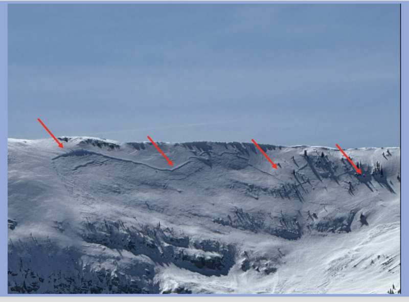
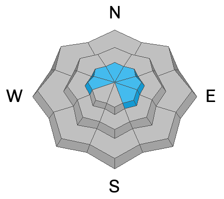
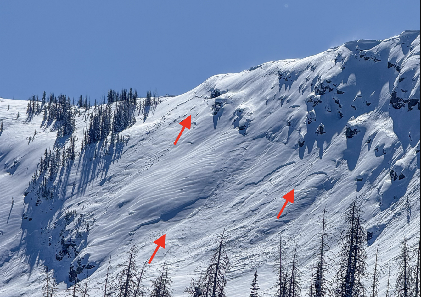
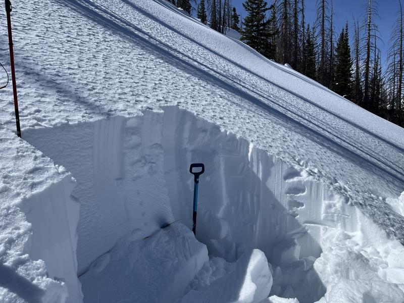
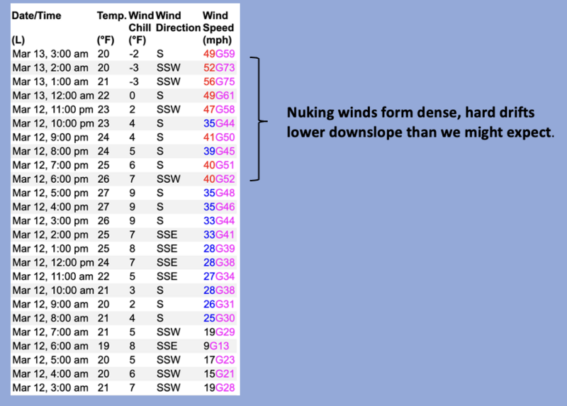
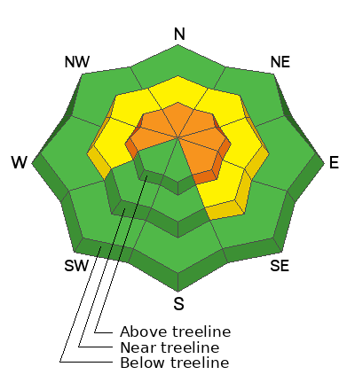
With an incoming storm avalanche danger rises to CONSIDERABLE on upper elevation slopes facing the north half of the compass. Human-triggered fresh wind drifts are LIKELY. Heads up... as today's storm materializes, avalanches may fail on persistent weak layers, producing a slide that breaks deeper and wider than we might expect. Steep, rocky terrain with a shallow snowpack fits the bill for slopes to avoid. While the snow feels solid under our feet, remember... unusually weak snow still lingers in the snowpack on upper elevation, shady slopes.
With more snow, water, and wind, mid elevation terrain gets in on the act. Expect MODERATE avalanche danger on steep, wind drifted slopes where human triggered avalanches are POSSIBLE.
Most south facing terrain is getting torched by the wind and offers generally LOW avalanche danger.
Low
Moderate
Considerable
High
Extreme
Learn how to read the forecast here
Special Announcements
Our Spring Campaign is in full swing, and there are two great ways to support forecasting, awareness, and education across Utah: Donate to our Spring Campaign or bid on items in our Spring Auction
Every dollar helps keep the backcountry community on top. Thank you for your support!
  • We come to you with heavy hearts and great sadness this morning to confirm an avalanche accident on Friday, March 7th near Hoyt Peak, involving 51 year old Micheal Janulaitis from Marion, Utah. Micheal used a snowbike to access the terrain, but was caught, carried, and killed in an avalanche while skiing a steep, northeast facing run on Hoyt Peak.
  • Huge thanks to the Department of Public Safety, Park City Mountain Resort and Canyons Village Snow Safety and Ski Patrol teams, along with Wasatch Backcountry Rescue for the hard work recovering Micheal and returning him to his family. Micheal was a friend of Utah Avy and we feel privileged for the time we got to spend together. This is a tremendous loss for our backcountry family and we will miss him deeply. We are compiling accident details and a preliminary report is available here.
Weather and Snow
Nowcast- Whelp... we need the wind (said no Uinta forecaster ever). As clouds stream into the region, our high ridges get absolutely blasted with bark peeling southwest winds blowing 50-75 mph. The warm before the storm delivers temperatures in the upper 20's.
Forecast- Expect increasing clouds with snow developing later this morning or early afternoon. Southerly winds blow 40-60 mph along the high ridges... yep, that's in the cow tipping category (though no cows were injured or hurt in the making of this simile :) Temperatures climb into the low to mid 30's, but crater into the teens as a thunder-snow producing cold front clobbers northern Utah right around sunset. I'm thinking this storm delivers 12"-16" of snow and hoping for an 1.5" of H2O to wrap up the workweek
Futurecast- After a relative lull for much of Friday, another system follows for late Friday into Saturday. Though weaker than today's storm, it'll usher in a high chance of accumulating snow and free refills.
Travel & Riding Conditions-
Get yer chores done today... tomorrow we go from mud season to winter and it's game on.
Recent Avalanches
Objects in the mirror are larger than they appear. We received some rudimentary beta on a rather well connected piece of snow, I suspect was cornice triggered on the tail end of last weeks storm. The image above is the northeast facing, hanging snow field in the alpine on the backside of Notch Mountain, just east of Mount Watson in the Mirror Lake Highway zone. Thanks to Kyle Cheston for the intel!
Ad
Avalanche Problem #1
Persistent Weak Layer
Type
Location
Likelihood
Size
Description
Above, a northeast facing slope around Anchor Lake hovering right around 11,000', is an example of a repeater slope... meaning it's avalanched several times and left behind a shallow, weak snowpack. These areas, steep and rocky, are where you are most likely to trigger today's persistent slab avalanche.
Today's storm is gonna be a good test for our snowpack and I think it'll reveal the somewhat cranky personalities of our problem children, several persistent weak layers of snow, now buried a couple feet from the snow surface. The problem is... the pack feels bomber under our skis, board, or sled. And while we forget about weak layers, the snowpack has an amazing memory. In fact, if you trench down, you'll still find weak, sugary facets beneath the surface, now buried between 1' and 3’ deep and that's the devious culprit behind recent persistent slab avalanches.
The next couple days are critical, so let's keep it tight and avoid terrain where we could trigger a slide that breaks deeper and wider that what we might've bargained for. Think... steep, rocky, shallow... like slopes that have avalanched several times already this winter.
Our main man with the Uinta plan, Ted Scroggin, was near Gold Hill Tuesday and noted... " I did get an ECTP27 that looked liked the column failed on some near surface faceted snow during a break in the storms."
Avalanche Problem #2
Wind Drifted Snow
Type
Location
Likelihood
Size
Description
Above, a 24 hour data dump from Lofty Lake Peak (11,186')
Most solar slopes are baked and there's little snow available to blow around. However, the Uinta's are a ginormous range and there are plenty of terrain features that accelerate wind, forming drifts on the leeward side of ridges, along with terrain features like chutes and gullies. You know the program... keep an eye out for and avoid rounded pillows and stiff, textured drifts that sound hollow like a drum.
Additional Information
From trailhead signs to transceiver training parks, we are always trying to help keep our community styled at the Uinta trailheads. It is no walk on the skin track to keep this signage and equipment up and running all season long. If you see one of our signs in rough shape, or our transceiver parks buried, reach out to us and let us know or feel free to dust off a solar panel and show it a little love. It is a community effort and we couldnt do it without you!
General Announcements
We are always looking for snow and avalanche observations or just general riding conditions. In the meantime reach out to us with questions, concerns, or if you see anything in your travels! Contact us directly through the info below:
This forecast is from the U.S.D.A. Forest Service, which is solely responsible for its content. This forecast describes general avalanche conditions and local variations always occur. This forecast was issued on Thursday, March 13th at 04:00 AM and expires 24 hours after it was issued.