Forecast for the Skyline Area Mountains

Brett Kobernik
Issued by Brett Kobernik on
Friday morning, February 28, 2025
No major change in conditions is expected through the weekend.
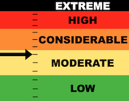
The majority of the terrain on the Manti Skyline has a MODERATE avalanche danger rating today.
There is still a chance that a person could trigger an avalanche that breaks into weak sugary loose snow from earlier in the season.
The most likely places to trigger something is on very steep north through east facing slopes.
Low
Moderate
Considerable
High
Extreme
Learn how to read the forecast here
Weather and Snow
Current Conditions: Temperatures got up to around 40˚F or a bit higher on Friday. There's a "temperature inversion" this morning where temperatures along the higher terrain are in the mid 30s and are in the low 20s down in the canyon bottoms. Wind has been light and variable in direction.
Mountain Weather: We'll have slightly warmer temperatures today compared to Friday with highs into the mid to upper 40s. Wind will be light and variable in direction. The weekend looks similar with slightly cooler temperatures and scattered high clouds moving in mid day on Saturday. A storm is shaping up for Monday that could bring a little snow refresher. The pattern continues to look fairly active through next week.
Ad
Avalanche Problem #1
Persistent Weak Layer
Type
Location
Likelihood
Size
Description
It is getting more unlikely that a person will trigger an avalanche that breaks deeper into faceted snow. However, this is still a distinct possibility. It's the nature of buried facets (loose sugary snow) to appear stable only to fail and release an avalanche when you least expect it.
So, lower chances for triggering an avalanche but consequences remain high. This is going to be the general trend through the weekend.
NOTE: There is a good chance that these buried weak layers will become more active again during and after future snow storms.
General Announcements
This forecast is from the U.S.D.A. Forest Service, which is solely responsible for its content. This forecast describes general avalanche conditions and local variations always occur.