Forecast for the Skyline Area Mountains

Brett Kobernik
Issued by Brett Kobernik on
Monday morning, February 10, 2025
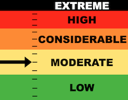
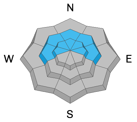
The overall danger rating on the Manti Skyline is MODERATE.
Human triggered avalanches are not all that likely but are certainly possible if you tickle the wrong place.
It's kind of like having land mines scattered about. The most likely place to trigger something today is where wind formed drifts and slabs on top of weak sugary snow.
Low
Moderate
Considerable
High
Extreme
Learn how to read the forecast here
Weather and Snow
Current Conditions: Sunday was a gorgeous day in the mountains with decent riding conditions, sunny skies and very light wind. Temperatures got into the mid 20s and dropped into the teens overnight. Wind from the west southwest has bumped up slightly in speed.
Mountain Weather: It'll be another nice day in the mountains with sunny skies, mostly light west wind, and temperatures into the mid 20s. Skies cloud up on Tuesday and a minor storm system moves through Tuesday night bringing a very minor amount of new snow. Another system is taking shape for Friday and Saturday that could deliver a more significant amount of snow.
Ad
Avalanche Problem #1
Persistent Weak Layer
Type
Location
Likelihood
Size
Description
You'll find areas where the wind drifted the most recent new snow forming some slabby areas in the higher terrain. These fresh drifts and slabs don't seem to be all that sensitive.
The bigger issue is older larger wind drifts that are sitting on top of weak sugary snow. A lot of these appear to be welded into place and are very stubborn to trigger. However, some will be easier to trigger. The problem is that it is difficult to differentiate between which ones will stay in place and which ones won't. The fresh snow from the weekend hid many of these drifts. Also, you can't tell if the drifts are sitting on top of weak sugary snow just by looking from a distance. This makes assessment difficult.
Here's the deal. Sugary faceted snow is known to be very tricky and will produce avalanches when you think things are stable. This is why we call it a Persistent Weak Layer. My strategy is that I don't mess around with steep slopes when there are widespead layers of sugary faceted snow in the snowpack just like what we have right now. Keep your slope angles under 30˚, and you'll stay safe.
.
General Announcements
This forecast is from the U.S.D.A. Forest Service, which is solely responsible for its content. This forecast describes general avalanche conditions and local variations always occur.