Forecast for the Skyline Area Mountains

Brett Kobernik
Issued by Brett Kobernik on
Sunday morning, February 9, 2025
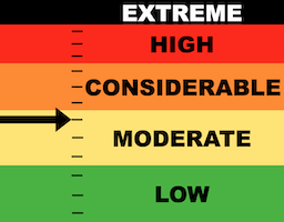
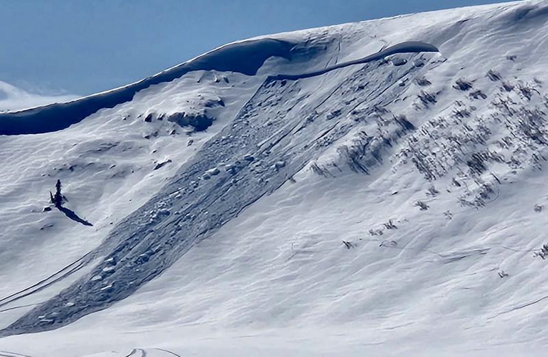
The overall danger rating on the Manti Skyline is at the upper end of MODERATE.
Human triggered avalanches breaking into Persistent Weak Layers of sugary faceted snow are possible.
Any steep slope with wind drifted snow on it is suspect, especially on the north half of the compass.
Low
Moderate
Considerable
High
Extreme
Learn how to read the forecast here
Weather and Snow
Current Conditions: The new snow from Friday night improved riding conditions but it is still very chunky underneath. Temperatures on Saturday crept into the mid 20s and dropped back to around 10˚F or into the single digits. The wind from the northwest increased into the moderate speed category Saturday afternoon and has continue through the night. This is certainly enough to drift the new snow.
Mountain Weather: We have a couple of nice days lined up with mostly sunny skies, light wind from the west and temperatures into the mid 20s. A minor storm system that moves through Wednesday bringing a chance for a small amount of snow. A better looking system is shaping up for later in the week.
Recent Avalanches
I'm sad to report that there was another avalanche fatality on Saturday. It was in the Salt Lake area mountains. PRELIMINARY REPORT HERE
There was a fairly significant avalanche triggered by snowmobilers on the Spring Creek Headwall near the kiting area at the top of Fairview Canyon. This avalanche was an older wind drift that broke deep into old weak facets. This continues to be the biggest threat on the Skyline right now. DETAILS HERE
Photo: Gustafson
Ad
Avalanche Problem #1
Persistent Weak Layer
Type
Location
Likelihood
Size
Description
The new snow was fairly well behaved on Saturday. The wind is definitely blowing and drifting it in the higher terrain. You may find areas where these fresh drifts and slabs will crack out on you. Most of these will be fairly shallow and really, they are the least of your problems.
Persistent Weak Layers of loose faceted snow poses the greatest threat. These layers formed in November, December and January. They are scattered across the entire state to varying degrees. There are older wind drifts and slabs sitting on top of these loose layers of snow. A lot of these drifts and slabs are very stubborn and don't want to release. Some will. There is no easy way to figure out which ones will stay put and which ones will release and ruin your day or worse. It's a roll of the dice if you're getting onto steep slopes.
.
General Announcements
This forecast is from the U.S.D.A. Forest Service, which is solely responsible for its content. This forecast describes general avalanche conditions and local variations always occur.