Observer Name
UAC Staff
Observation Date
Thursday, February 6, 2025
Avalanche Date
Monday, February 3, 2025
Region
Ogden » Monte Cristo
Location Name or Route
Monte-Cristo-Beer Hill
Elevation
8,800'
Aspect
East
Slope Angle
32°
Trigger
Snowmobiler
Trigger: additional info
Unintentionally Triggered
Avalanche Type
Hard Slab
Avalanche Problem
Wind Drifted Snow
Weak Layer
Facets
Depth
3'
Width
400'
Vertical
200'
Caught
1
Carried
1
Buried - Fully
1
Killed
1
Accident and Rescue Summary
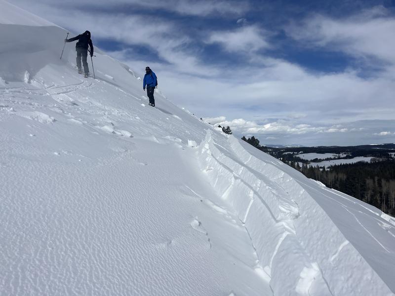
On Monday, February 3, 2025, Warren Ethridge and Scott Wright set out on snowmobiles from the Woodruff trailhead towards the Monte Cristo area. While Scott had previously snowmobiled in the region, this was Warren's first time there. Upon nearing Beer Hill, both riders ascended the slope. Warren ascended first, veering right and then descending. As Warren descended, Scott began his ascent, climbing higher toward the center of the hill before turning his snowmobile left. It was during this turn that the avalanche occurred, catching Scott, carrying him, and burying him completely.
Warren immediately called 911 for assistance. Although he knew Scott’s last known location, he did not have rescue equipment and was uncertain whether Scott was equipped with a beacon. At 3:03 p.m., Rich County Search and Rescue was dispatched.
Approximately an hour later, LifeFlight arrived and provided Warren with a rescue pack(containing a beacon, shovel, and probe). Despite efforts to locate a beacon signal, Warren was unsuccessful.
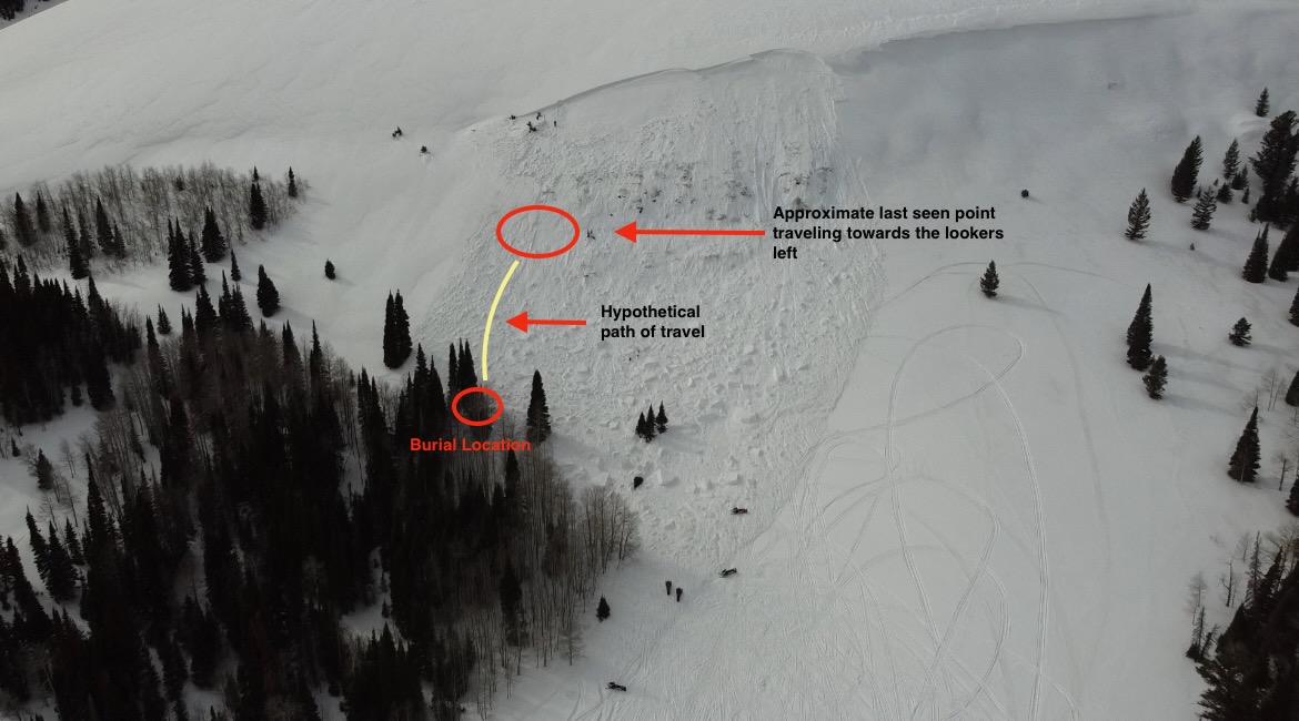
Patrollers from Powder Mountain and two avalanche rescue dogs arrived at about 4:45 PM and began a hasty search using dogs, beacons, and probes. Additional search and rescue teams from Rich, Weber, and Cache counties joined the effort. A rescue dog alerted ten feet uphill from where Scott was buried. The rescue team probed the area near the alert and around the nearby tree (where Scott was) but got no strikes. They continued with grid-based probe lines, and someone noticed the smell of gasoline during this time. They re-directed the probe line and got a strike on his snowmobile, which was buried about 3 to 4 feet deep. At 6:21 PM, as the search team dug around the snowmobile, Scott was located between it and a large fir tree.
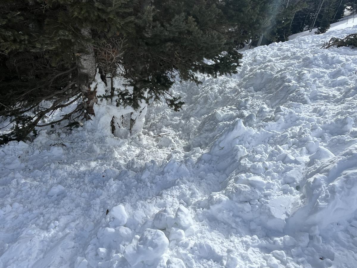
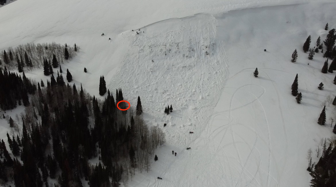
Photo of tree island where Scott and the snowmobile were dug out.
Photo with marked burial location
Terrain Summary
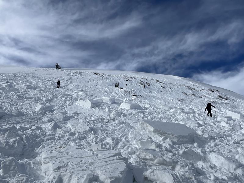
This avalanche occurred on an east-facing slope in the Monte Cristo Range, 30 miles northeast of Ogden, Utah. The crown face of the avalanche was at an elevation of 8,800 feet, and the toe was at 8,600 feet. This avalanche was 394 feet wide. The crown depth averaged 3 feet deep and was 5 feet deep at the maximum crown height.
This slab of wind-drifted snow failed on a layer of buried near-surface facets and broken precipitation particles and also involved the more deeply buried facets that formed near the ground in December of 2024. This was a hard wind slab, with large chunks of debris remaining intact in the debris field.

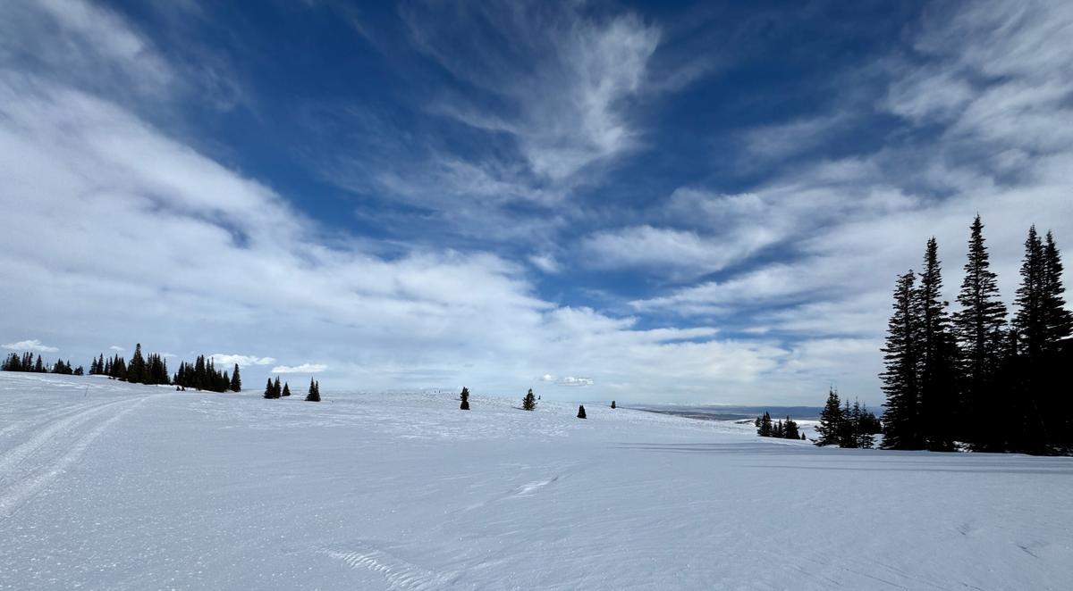
Photo of hard slab debris
Strong winds heavily drifted the upper portion of the slope, creating a dense, cohesive, pencil-hard wind slab. The slope angle in the rocky area mid-slope was 43 degrees, and the slope angle at the crown face averaged 31 degrees.
A notable terrain feature likely related to the extensive wind loading on this slope is the large flat meadow above and behind the slope. This meadow is a large fetch, where wind can blow over land for quite a distance with no obstructions. The first available downwind terrain features are the two slopes in the leeward zone: Beer Hill and Whisky Hill. Even in a shallow snowpack season, we can see depths of over 15 feet of snow (4 meters) on these slopes based on wind direction.
Photo of meadow (fetch) above Beer Hill. The Google Earth photo which is summer imagery shows more of the meadow.


Weather Conditions and History
From Friday, January 31, through Monday, February 3, the region experienced a dynamic weather pattern marked by heavy, wet snowfall, strong winds, and warming temperatures.
On Friday, January 31, conditions were relatively calm, with clear skies and temperatures in the mid-20s °F. Winds remained light from the west, gusting into the 20s MPH along exposed ridgelines. Saturday, February 1, cloud cover increased, and winds strengthened from the northwest and southwest, with gusts exceeding 50 MPH at the highest ridgelines. Snowfall continued throughout the day. By Sunday, February 2, temperatures continued to rise, with trailhead readings reaching the low 40s°F and upper elevations in the high 20s°F. Winds became a dominant factor, intensifying significantly and gusting from a westerly direction over 60 MPH at 9,000 feet.
Snow Data
Snow Data
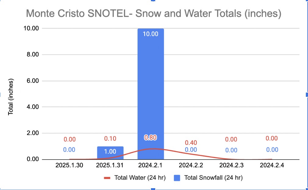
Snow and water totals for the storm cycle from January 30th-Febuary 3rd as measured at the Monte Cristo SNOTEL 8931’ (graph below).
The storm delivered a total of 12 inches of snow and 1.4 inches of water to the Monte Region and 12- 20 inches of snow and 1.4 to 2.5 inches of water to the Ogden Forecast Region.
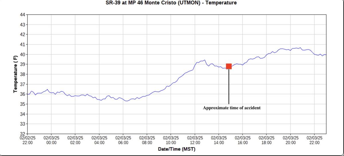
Temperature Data
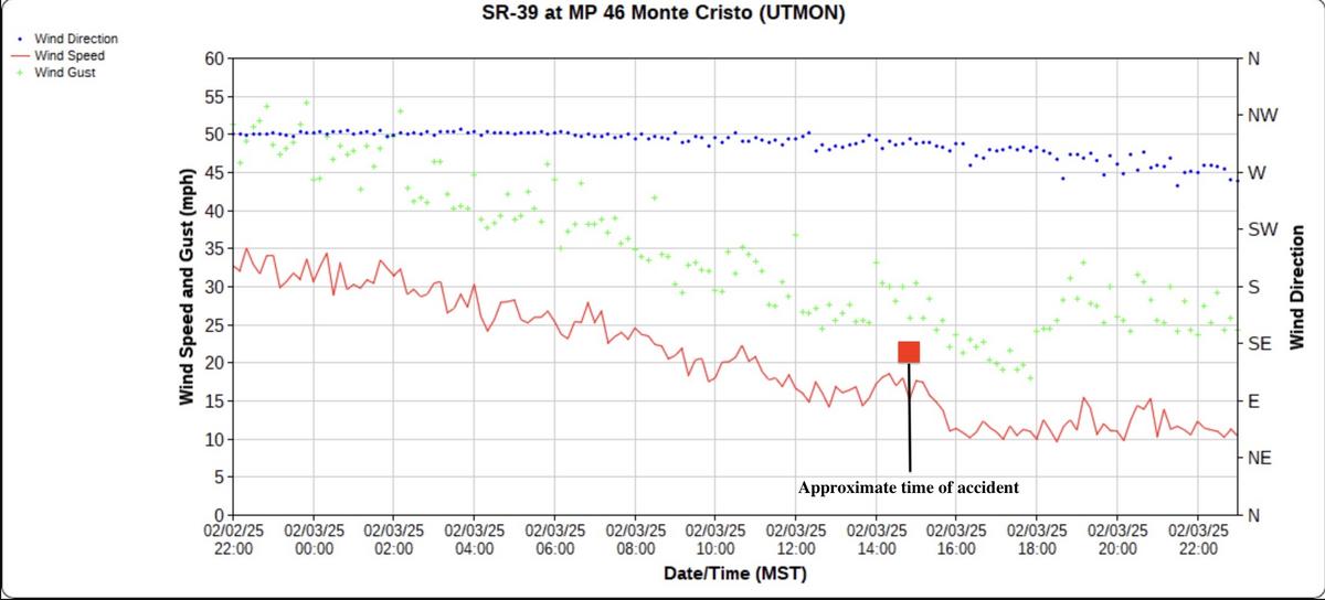
On Monday, February 3, a warming trend persisted, with trailhead temperatures climbing into the 40s and 50s°F, while the highest peaks hovered around 35°F, failing to drop below freezing overnight. Strong westerly winds continued, gusting up to 65 MPH at higher elevations.
Temperature run and average air temperature from Monte Cristo (8931’) from January 30, 2025, to February 03, 2025. This shows us rising air temperatures at the tail end of the storm.

Wind Data
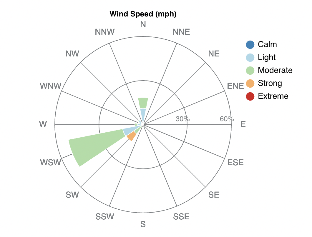
Wind rose and average speeds from James Peak (9425’), which is approximately 18.5 miles southwest of the site of this avalanche. The graphs show wind direction, distribution, and speeds from January 30, 2025 to February 03, 2025.
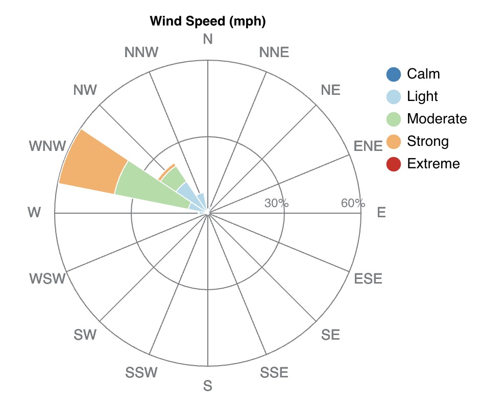
Monte Cristo Wind 8,966’ located four miles southwest of the accident site showing wind direction rose from January 30, 2025 to February 3, 2025.
Monte Cristo Site SR-39 (8,966’) located four miles southwest of the accident site showing air temperatures, wind direction speed, and gusts from February 2, 2025, to February 3, 2025, with the accident time marked.
Avalanche Forecast
The avalanche danger for the Ogden Region on Monday, February 3, 2025, was CONSIDERABLE on this aspect and elevation. The bottom line for the day was that humans could likely trigger wind-drifted snow avalanches failing on one of two layers of buried facets.
Snow Profile Comments

Comments
The crown in the flank (Monte E 8,806’) showed two failure planes with propagation tests, one failure on a layer of buried near surface facets 19 inches (50cm) from the ground, and one failure 10 inches (24cm) from the ground on a layer of depth hoar, which matches what we observed on the bed surface. The slab above both weak layers was a stout layer of wind-drifted snow blown in from strong, westerly winds.
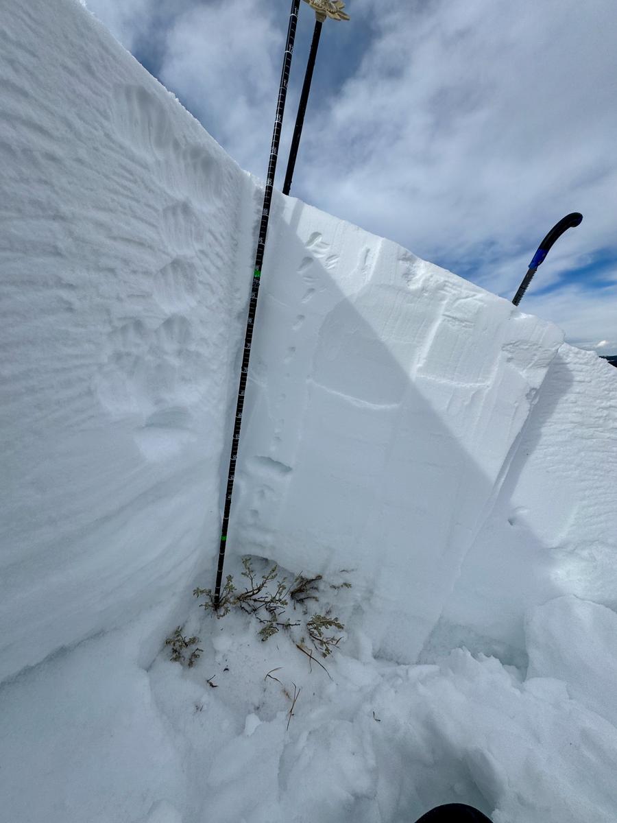
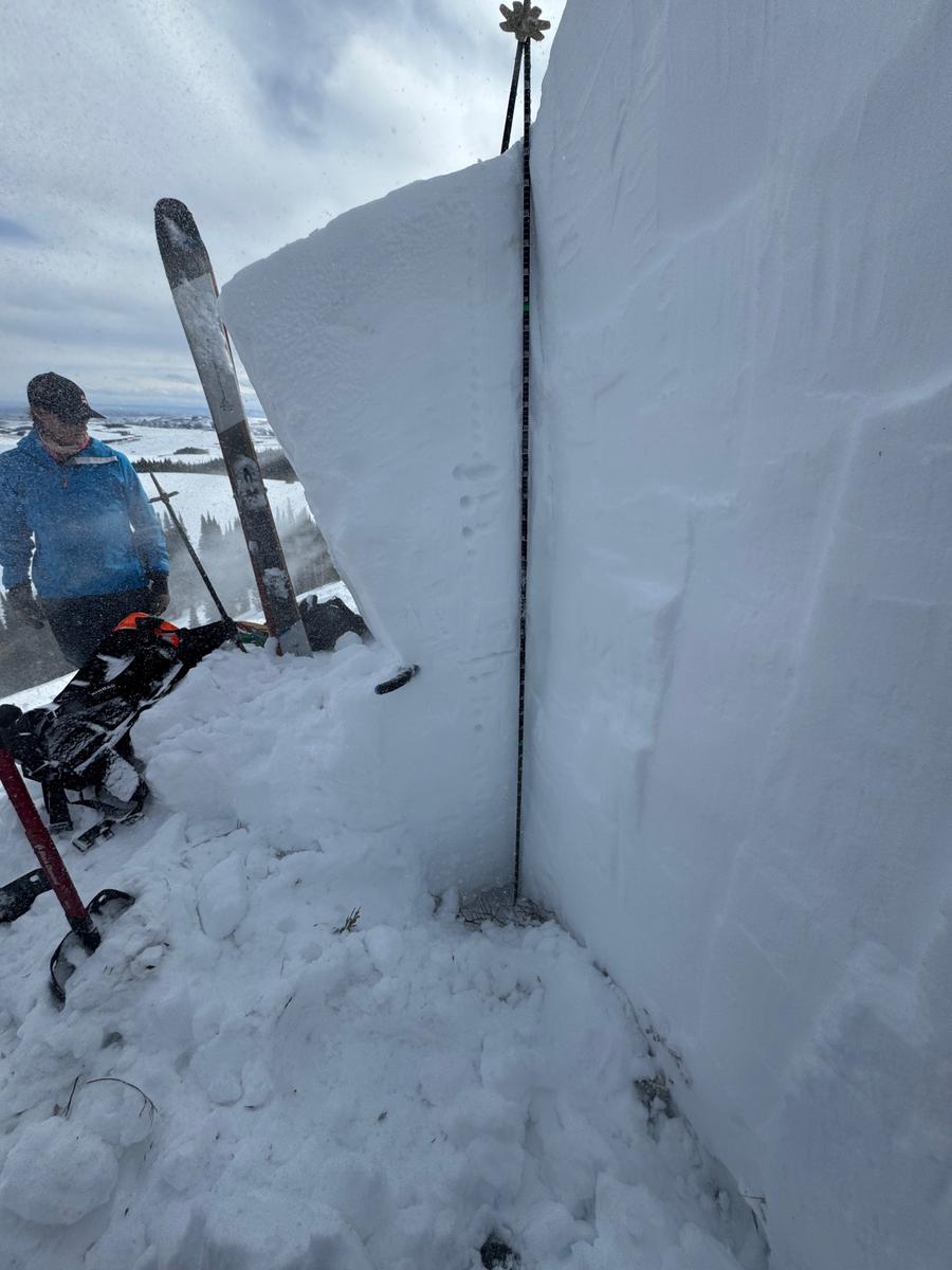
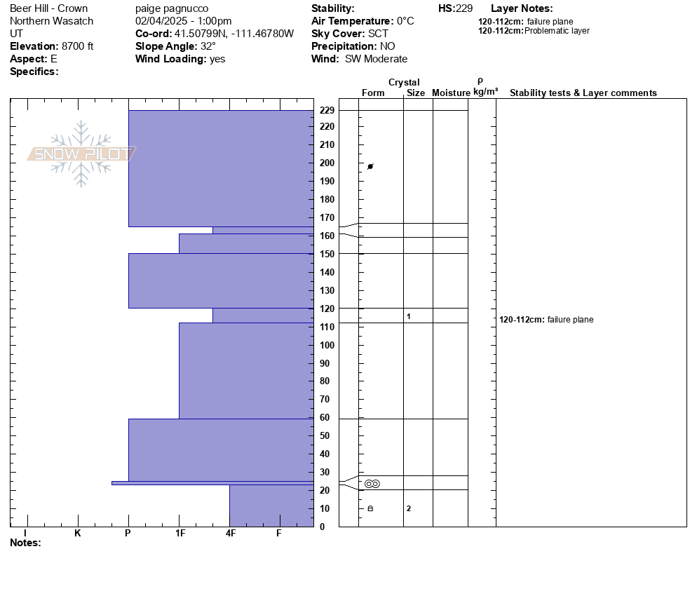
Snowpit below in the center lookers left of the crown in a much deeper and more wind affected location. This snowpit shows the variability of the bed surface and history of multiple wind events.
Comments
At the Utah Avalanche Center, we strive to learn from every avalanche incident and share insights to help others avoid similar accidents. We have all experienced close calls and understand how easily mistakes can happen. Our goal with this report is to provide a valuable learning opportunity. With that in mind, we offer the following comments:
- Warren did not have avalanche rescue equipment. Had they both been wearing transmitting beacons, Warren could have narrowed the search area.
- Scott was wearing an armed airbag, but it was not deployed.
We are thankful to the rescuers who assisted in this search and recovery. Rich County Sheriff’s Office members responded, as did personnel from Cache County, Weber County, Life Flight, the Utah Department of Public Safety, Powder Mountain, and the Diesel Brothers.
We aim to learn from accidents like this and in no way intend to point fingers at victims. Thank you to all the community members who participated in this rescue and provided closure to this individual's family and friends.
Comments
Typically in an avalanche the victim will travel down the fall line from their last-seen area and clues; hats, gloves, ski poles, snowmobile parts will also line up with the victim, and knowing approximately where to start searching improves the chances of a faster recovery (Tremper, Staying Alive in Avalanche Terrain, page 250). In this case, there was a last-seen location. A take home from this avalanche is to follow the last-seen location or just past it in the case of a traverse across the slope and start the search fall line from the last-seen location (photo of hypothetical path of travel marked in yellow). Scott ended up buried fall-line from the last-seen point. In the case of partner rescue this can save valuable time and potentially change the outcome of a burial.


Video
Coordinates


