Forecast for the Skyline Area Mountains

Brett Kobernik
Issued by Brett Kobernik on
Thursday morning, February 6, 2025
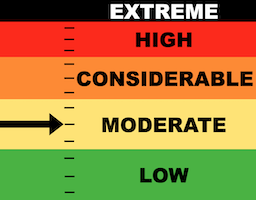
The overall avalanche danger today on the Manti Skyline is MODERATE.
Human triggered avalanches are not all that likely today.
That said, the wind has been relentless for weeks and there are lots of drifts and slabs that have formed especially in the highest terrain. Some of these may crack out today if provoked.
Also, with continued warm temperatures, you'll want to keep wet avalanche activity in mind in the low and mid elevations. Avoid steep slopes where the snow is wet and sloppy and unsupportable.
Low
Moderate
Considerable
High
Extreme
Learn how to read the forecast here
Special Announcements
There is a preliminary report about the fatal avalanche accident in Monte Cristo HERE
Weather and Snow
Current Conditions: Temperatures crept into the mid 30s to around 40 on Wednesday and dropped back to near freezing overnight. This was the coolest 24 hour period that we've seen this week. Wind from the southwest really ramped up for a while on Tuesday and has slowed a bit but is still breezy along the higher terrain. A trace of snow fell around 10pm Wednesday night. Looks like it was mostly graupel.
Mountain Weather: We have another mild day in store with sun and temperatures again into the mid 30s to around 40˚F. Wind continues from the southwest but it looks like it will be only in the moderate speed category today. Friday is slightly cooler, cloudier and windier. A cold front quickly sweeps through Friday evening that should bring 2 to 4 inches of new snow or perhaps a bit more if we're lucky.
Ad
Avalanche Problem #1
Persistent Weak Layer
Type
Location
Likelihood
Size
Description
The focus is still on all the weak sugary snow that is in various layers within our snowpack. Persistent Weak Layers of sugary facets exist in many locations ranging from the bottom of the snowpack, through the entire snowpack in shallow spots, and a layer near the surface as well. There are two situations to keep in mind today:
  • Wind drifted snow. We've had weeks of wind on and off. This wind formed drifts, slabs, and cornices in the high terrain. Many of these will be stubborn and stay in place. Some may crack out. Faceted snow is the wild card and my bet is that anything that cracks out today will break into a layer of facets.
  • Wet snow in the low and mid elevations. The wet avalanche activity I've seen this week all involved buried facets as a weak layer. With the gradual cooling trend, I'm thinking we're past the hump where we'll see much wet snow avalanche activity. However, you won't find me monkeying around in unconsolidated sloppy wet snow around any steep slopes today. This issue will pass as temperatures continue to cool down this weekend but use caution still today.
.
General Announcements
This forecast is from the U.S.D.A. Forest Service, which is solely responsible for its content. This forecast describes general avalanche conditions and local variations always occur.