Forecast for the Skyline Area Mountains

Brett Kobernik
Issued by Brett Kobernik on
Wednesday morning, February 5, 2025
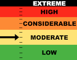
The overall avalanche danger today on the Manti Skyline is MODERATE.
Keep an eye out for recently formed wind drifts in the higher terrain. It's possible you could trigger one but chances are becoming more unlikely.
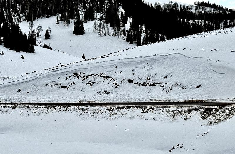
The more likely type of avalanche today is a wet snow avalanche in the low and mid elevation terrain. Avoid very steep slopes where the snow is wet, saturated, sloppy and punchy.
Low
Moderate
Considerable
High
Extreme
Learn how to read the forecast here
Special Announcements
There is a preliminary report about the fatal avalanche accident in Monte Cristo HERE
Weather and Snow
Current Conditions: It was another really odd day in the mountains on Tuesday due to the continued very warm temperatures. Highs again were well into the 40s. The snow has become damp on all aspects up to around 9600' or a bit higher. Lower than that, the snowpack is wet and saturated all the way through to the ground in many areas. Wind was light to moderate but has increased again overnight into the moderate to strong range across the highest ridges.
Mountain Weather: We'll see mid level clouds move in today with the chance for light snowfall. The rain/snow level will be in the 7500 to 8000 foot range. No real accumulations are expected. Temperatures will be slightly cooler than Tuesday but still reaching into the upper 30s and low 40s. Southwest wind is going to be a bit breezy with speeds in the moderate to strong categories. A cold front is scheduled to move through late Friday which actually could bring a shot of measurable snow.
Recent Avalanches
On Tuesday, I stumbled onto a very interesting wet slab avalanche. This was the result of a combination of a wind loaded very steep slope with a faceted buried weak layer that failed during an extreme warming event. MORE DETAILS HERE It is possible we still may see similar slides today.
Ad
Avalanche Problem #1
Persistent Weak Layer
Type
Location
Likelihood
Size
Description
Any avalanche that occurs today will have a Persistent Weak Layer of sugary facets. There are areas where the snowpack is shallow and consists entirely of facets. There are areas where the pack is deeper with facets near the ground. And there is a layer near the surface that has turned to facets over the last few weeks. There are two different situations to keep in mind that both involve the faceted snow.
  • Recently formed wind drifts may break into the upper layer of facets or possibly break into deeper facets. This situation is most pronounced in the high terrain where the wind drifted snow is more prevelant. Chances for triggering one of these wind slabs is not all that great right now.
  • In the low and mid elevation terrain, wet snow avalanches breaking into faceted snow should be considered. Some of the facets are dry but a lot are damp now. I experienced collapsing of the snowpack into wet facets on Tuesday. This is a sure sign of unstable snow. These wet avalanches are the most likely thing we'll see today but that said, they are going to happen in odd locations where most people don't recreate. And they need a very steep slope of at least 35˚ or closer to 40˚. They key is that if you find yourself in wet, sloppy, unsupportable snow where you're sinking deep into a wet mess, avoid being on or below any steep slope.
.
General Announcements
This forecast is from the U.S.D.A. Forest Service, which is solely responsible for its content. This forecast describes general avalanche conditions and local variations always occur.