AVALANCHE WARNING!! Tap for info

Forecast for the Skyline Area Mountains

Brett Kobernik
Issued by Brett Kobernik on
Wednesday morning, January 29, 2025
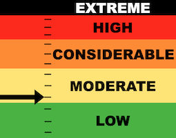
.
The avalanche danger on the Manti Skyline is MODERATE.
Scattered pockets of wind drifted snow pose the greatest threat today although, it's really not all that big of a threat.
While most of these pockets that you might get to release won't pose a huge threat, some of them could be large enough to cause some harm.
They are most pronounced in the upper elevation terrain that faces west, north and east, especially right around terrain features and below ridges.
Low
Moderate
Considerable
High
Extreme
Learn how to read the forecast here
Special Announcements
URGENT!! Battery replacement required for anyone who received batteries from one of our participating "Batteries for Beacons" shops. We've found that the Duracell Procell AAA batteries are too short in length and may not make contact in avalanche beacons causing them to malfunction. DETAILS HERE
Weather and Snow
Current Conditions: The snowpack is pretty beat up from a long period with no snow and numerous days of moderate speed wind. The wind has been from the east northeast in the light to moderate speed category. Temperatures have been in the low to mid 20s.
Mountain Weather: We'll see a pretty nice day today with mostly clear skies, high temperatures into the upper 20s to low 30s, and light to moderate wind from the northeast. Thursday and Friday look similar then the pattern looks like it'll change on Saturday. I'm not going to speculate a whole lot yet but the pattern looks a little more active and we could see some snow.
Ad
Avalanche Problem #1
Wind Drifted Snow
Type
Location
Likelihood
Size
Description
There are pockets of wind drifted snow scattered all over the place in the mid and higher elevations. My partner and I triggered a small one on Tuesday. It was shallow and didn't move anywhere. It just cracked out. These are what you'll see for the most part out there today. However, some of them may be large enough to knock you around. .
Avalanche Problem #2
Persistent Weak Layer
Type
Location
Likelihood
Size
Description
The overall strucure of the snowpack is poor. There is way more loose sugary snow around than I like to see. For the most part, it is currently "dormant" meaning that it is fairly unlikely to trigger an avalanche that breaks deep into the weak sugary snow. Where you might find trouble is in areas where the wind has deposited snow and formed drifts recently.
The key to staying safe out there right now is simply avoiding drifts, pillows, slabs, cornices or any other type of wind drifted snow formation that is on steep slopes that face west, north and east above about 8500 feet. Again, the chances for triggering a deep avalanche aren't all that great but there's still a chance.
General Announcements
This forecast is from the U.S.D.A. Forest Service, which is solely responsible for its content. This forecast describes general avalanche conditions and local variations always occur.