AVALANCHE WARNING!! Tap for info
UDOT PLANNED AVALANCHE CLOSURES!!

Forecast for the Moab Area Mountains

Eric Trenbeath
Issued by Eric Trenbeath on
Saturday morning, January 25, 2025
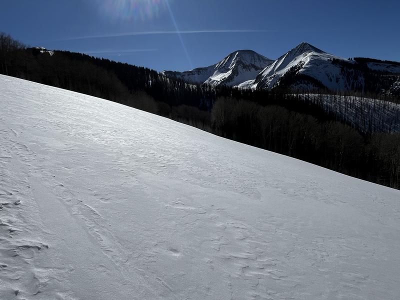
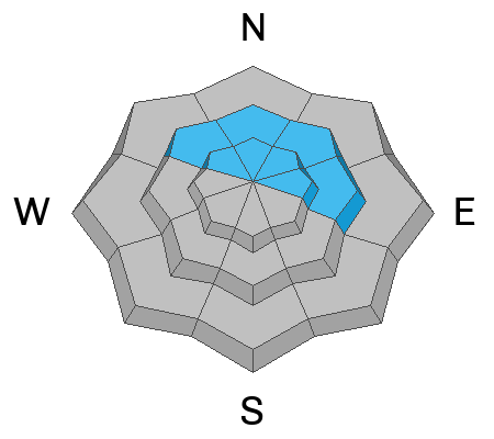
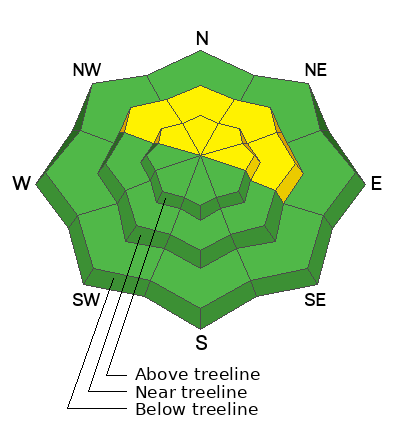
An isolated or MODERATE avalanche danger exists where you can detect slabs of wind drifted snow on top of weak, sugary, faceted snow. This problem is most pronounced on steep slopes that face NW-N-NE-E right around treeline. Human triggered avalanches 1 to 2 feet deep are possible.
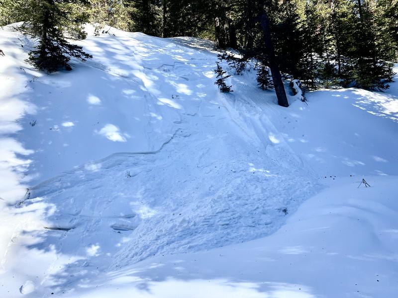
Loose, dry avalanches are likely on very steep, sheltered, northerly facing terrain below treeline. Generally small, and not large enough to bury you, they could sweep you off your feet and take you for a ride.
Most other terrain has LOW danger. Small avalanches on isolated terrain features are possible.
Low
Moderate
Considerable
High
Extreme
Learn how to read the forecast here
Special Announcements
Urgent battery replacement required for anyone who received batteries from one of our participating "Batteries for Beacons" shops. Please review the "Batteries for Beacons" replacement notice on our blog. Batteries distributed through our "Batteries for Beacons" program this year have shown to be inadequate length.
Geyser Pass Road: Surface is mainly snowpacked and icy. AWD with good tires required.
Grooming Conditions: Gold Basin through Geyser Pass was last groomed a week ago and the surface is getting a bit rough.
Weather and Snow
6 A.M. Snow and Weather Data
24 Hour Snow: 0" 72 Hour Snow: 0" Season Total Snow: 63" Depth at Gold Basin: 29"
Winds on Pre-Laurel Peak: S 15-20 G 30Temp: 26° F Percent of Normal (SWE): 79%
Weather
Ridge top winds out of the southwest blew in the moderate to strong range most of the day yesterday and they continue to do so this morning. A weak storm system dropping down from the north will bring clouds to our area today. Winds should die down, and high temperatures will be about what they are. Look for decreasing clouds on Sunday. A weak cut off low passes by to the south on Tuesday bringing a diminishing chance for snow. The next weekend carrot is being pushed out further and now it looks like around Feb 3 before we start seeing snow.
General Conditions
In my travels yesterday I was surprised to find soft snow on most aspects below treeline where the wind hadn't been. Conditions deteriorate as you gain elevation. The entire snowpack on shady aspects below treeline has faceted and lost cohesion. Yesterday, I was able to initiate loose, dry avalanches on very steep gully walls in this very weak snow. These small avalanches won't be enough to bury you, but they could sweep you off your feet so have some situational awareness when traversing or dropping steep terrain below terrain. And finally, we still have a lingering but diminishing concern over avalanches failing on a persistent weak layer. More on that below.
I was suprised to find lightly wind affected, but soft snow in this low angle terrain below treeline yesterday:
Above treeline, this more the standard fare:
Small, loose, "facet-lanche" on a steep gully wall:
Snowpack and Weather Data
Gold Basin SNOTEL site (10,000')
SNOTEL site near Geyser Pass Winter Trailhead (9600')
Wind Station on Pre-Laurel Peak (11,400')
NWS forecast for the La Sal Mountains.
Recent Avalanches
Ad
Avalanche Problem #1
Persistent Weak Layer
Type
Location
Likelihood
Size
Description
Although increasingly unlikely, it is still possible to trigger an avalanche on a weak layer of faceted snow that's buried about a foot below the surface on steep slopes that face NW-N-E. The danger is most acute near treeline where slabs of wind drifted snow have formed over top of the weak layer. Above treeline, the problem is very isolated as a result of all the wind scouring we have experienced over the past month. This is a unique situation as avalanche danger generally increases with elevation. For more on this, see Dave's thoughtful analysis below.
An even less likely, but not impossible scenario, are human triggered avalanches failing on facets near the ground. Minimize this type of risk by avoiding thin snowpack areas and very steep, rocky, radical terrain.
Additional Information
Forecaster's Corner: Slopes in the alpine are heavily scoured on all aspects and the slabs and weak layers are not well connected across this terrain. Areas that are not heavily scoured have a deep snowpack and strong snow. The average height of snow in these areas is 4.5 to almost 6 feet deep. This is a much different snowpack compared to lower elevations. The chances of triggering a deep avalanche failing on facets above treeline are low, but we continue to avoid steep, shallow, rocky areas to have the greatest margin of safety. Faceted layers still exist in this terrain, and future loading events can bring back a PWL problem. Be sure to read my latest observation for more information.
Sign up for text alerts to get the most up to date information about changing conditions, road plowing, special avalanche announcements.
Follow us on Instagram @utavy_moab
General Announcements
This forecast is from the U.S.D.A. Forest Service, which is solely responsible for its content. This forecast describes general avalanche conditions and local variations always occur.