AVALANCHE WARNING!! Tap for info
UDOT PLANNED AVALANCHE CLOSURES!!

Forecast for the Moab Area Mountains

Eric Trenbeath
Issued by Eric Trenbeath on
Friday morning, January 24, 2025
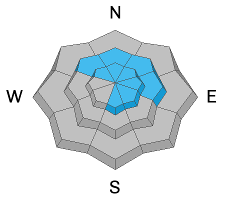
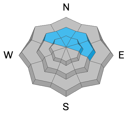
A MODERATE avalanche danger exists on recently wind drifted slopes near and above treeline, particularly on slopes with an easterly component to their aspect.
It's also still possible to trigger an avalanche 1-2 feet deep where slabs of wind drifted snow exist over a weak layer of buried facets. This problem is most pronounced on steep slopes that face NW-N-NE-E right around treeline.
Low
Moderate
Considerable
High
Extreme
Learn how to read the forecast here
Special Announcements
Urgent battery replacement required for anyone who received batteries from one of our participating "Batteries for Beacons" shops. Please review the "Batteries for Beacons" replacement notice on our blog. Batteries distributed through our "Batteries for Beacons" program this year have shown to be inadequate length.
Geyser Pass Road: Surface is mainly snowpacked and icy. AWD with good tires required.
Grooming Conditions: Gold Basin through Geyser Pass was groomed Saturday.
The beacon park is up and running. High pressure is a great time to work on your beacon skills.
Weather and Snow
6 A.M. Snow and Weather Data
24 Hour Snow: 0" 72 Hour Snow: 0" Season Total Snow: 63" Depth at Gold Basin: 29"
Winds on Pre-Laurel Peak: NW15-20 Temp: 12° F Percent of Normal (SWE): 79%
Weather
Ridge top northwest winds have averaged 10-15 mph with gusts into the 20's for the past 24 hours. Today look for sunny skies, light to moderate southwest winds, and high temperatures in the mid 20's. Look for increasing clouds tonight ahead of a weak system dropping down from the north. Saturday will be mostly cloudy and breezy with a chance for snow developing Saturday night. Look for partly sunny conditions on Sunday with a slightly better chance for snow early next week as a cut off low moves through the 4 Corners. Beyond that, there's a glimmer of hope for a southerly tracking system on a southwest flow by next weekend. Keep your fingers crossed that this will signal a change for February.
General Conditions
Our wind battered snowpack continues to take a beating and most surfaces are tired, textured, crusted, or hard. You might still be able to find some soft snow out there that was slightly enhanced by the 3 inches that fell over the weekend. Sheltered, northerly facing terrain below treeline will be the go to areas.
Shallow, stiff slabs of wind drifted snow from Wednesday's wind event should be pretty well stuck in place today, but there may be a few unstable drifts about. We also still have some concern over the faceted weak layer that was buried on 12/25. This layer may still be sensitive where you can find a cohesive slab on top. We have found this layer to be the most reactive on wind loaded northerly aspects near treeline.
Snowpack and Weather Data
Gold Basin SNOTEL site (10,000')
SNOTEL site near Geyser Pass Winter Trailhead (9600')
Wind Station on Pre-Laurel Peak (11,400')
NWS forecast for the La Sal Mountains.
Recent Avalanches
Ad
Avalanche Problem #1
Wind Drifted Snow
Type
Location
Likelihood
Size
Description
There may still be a few unstable slabs of wind drifted snow out there as a result of Wednesday's northwest wind event. Winds from this direction tend to create some odd loading patterns. On northerly aspects, you are likely to find cross-loaded gullies and depressions. On south and easterly aspects, expect to find wind loading along leeward facing ridge lines, as well as on mid-slope terrain features. If the snow all of a sudden feels stiffer and more compact, you have found a fresh drift. Hollow sounds, collapsing, and shooting cracks are tell-tale signs of wind-drifted snow.
Avalanche Problem #2
Persistent Weak Layer
Type
Location
Likelihood
Size
Description
Although increasingly unlikely, it is still possible to trigger an avalanche on a weak layer of faceted snow that's buried about a foot below the surface on steep slopes that face NW-N-E. The danger is most acute near treeline where slabs of wind drifted snow have formed over top of the weak layer. Above treeline, the problem is very isolated as a result of all the wind scouring we have experienced over the past month. This is a unique situation as avalanche danger generally increases with elevation. For more on this, see Dave's thoughtful analysis below.
An even less likely, but not impossible scenario, are human triggered avalanches failing on facets near the ground. Minimize this type of risk by avoiding thin snowpack areas and very steep, rocky, radical terrain.
Additional Information
Forecaster's Corner: Slopes in the alpine are heavily scoured on all aspects and the slabs and weak layers are not well connected across this terrain. Areas that are not heavily scoured have a deep snowpack and strong snow. The average height of snow in these areas is 4.5 to almost 6 feet deep. This is a much different snowpack compared to lower elevations. The chances of triggering a deep avalanche failing on facets above treeline are low, but we continue to avoid steep, shallow, rocky areas to have the greatest margin of safety. Faceted layers still exist in this terrain, and future loading events can bring back a PWL problem. Be sure to read my latest observation for more information.
Sign up for text alerts to get the most up to date information about changing conditions, road plowing, special avalanche announcements.
Follow us on Instagram @utavy_moab
General Announcements
This forecast is from the U.S.D.A. Forest Service, which is solely responsible for its content. This forecast describes general avalanche conditions and local variations always occur.