UDOT PLANNED AVALANCHE CLOSURES!!

Observation: Silver Fork

Observation Date
12/27/2024
Observer Name
Kelly, Kelly, Champion
Region
Salt Lake » Big Cottonwood Canyon » Silver Fork
Location Name or Route
Grizzly-East Bowl-West Bowl- Emma's
Weather
Sky
Obscured
Precipitation
Heavy Snowfall
Wind Direction
Southwest
Wind Speed
Moderate
Weather Comments
Obscured skies with heavy snowfall throughout the tour. Winds were primarily blowing from southwest although there were some gusts from the northwest as the afternoon progressed. Rimed snowflakes fell throughout the day. We had warming temperatures throughout the day.
Snow Characteristics
New Snow Depth
12"
New Snow Density
High
Snow Surface Conditions
Powder
Snow Characteristics Comments
Snow was high density rimed stellars and graupel. In many areas it was heavily wind affected by the strong westerly winds. On lower angle slopes it was nice to travel and not hit rocks, stumps, or the ground. On steeper southerly facing slopes we were still hitting the summer surface.
Red Flags
Red Flags
Heavy Snowfall
Wind Loading
Cracking
Collapsing
Poor Snowpack Structure
Red Flags Comments
The only thing really missing today was more weight. It could be the additional weight of a rider, wind loaded snow, or just more snow straight out of the sky. We are nearing the tipping point and we had many collapses, cracks, and whumpfs on any slope holding the old persistent weak layer-primarily on north-east facing terrain and in lower angle meadows. We did get some localized cracking and collapsing near ridge lines on south-east facing aspects which all involved wind-drifted snow features.
Avalanche Problem #1
Problem
Wind Drifted Snow
Problem #1 Comments
Wind drifted new snow would be the primary problem and combined with the persistent weak layer is going to make for large avalanches that may be 1'-3' deep and up to 600' wide. The areas of wind drifted snow are starting to get wider as they fill out more of the terrain features. This will make for bigger avalanches. We saw lots of cornice growth on ridgelines and were able to trigger soft wind slabs on northeast, west, and southwest aspects.
Photo of cornice growth on East Bowl Pass from strong westerly winds.

Photo of shallow wind drifted snow avalanche on a southwest aspect at 9,600'

Photo of shallow wind drifted snow avalanche on a west facing aspect at 10,000'
Photo of shallow wind-drifted snow avalanche on north east facing Davenport Hill 10,100'

Additional photo of wind drifted snow avalanche from above, entraining new snow
Avalanche Problem #2
Problem
Persistent Weak Layer
Problem #2 Comments
The weak snow that has been with us since early season is now getting its first major weight addition. Give this layer time to heal as many of the snow-pits on our observations page show poor structure. For now on mid and upper elevation slopes over 30° if you're not hitting rocks, stumps, and the ground then it's likely you're traveling on a buried persistent weak layer. I will be avoiding any slope connected to, below, or touching a slope greater than 30° in steepness with the buried persistent weak layer (PWL) present. Over the weekend this layer will be in your face with lots of signs of cracking, collapsing, and whumpfing. This will get harder to manage when the storm ends, and any slope that didn't avalanche will be suspect.
Photo of shooting cracks east aspect at 9,800'
Additional shooting cracks east aspect near 10,000'
Snow Profile
Aspect
Northwest
Elevation
9,900'
Slope Angle
33°
Comments

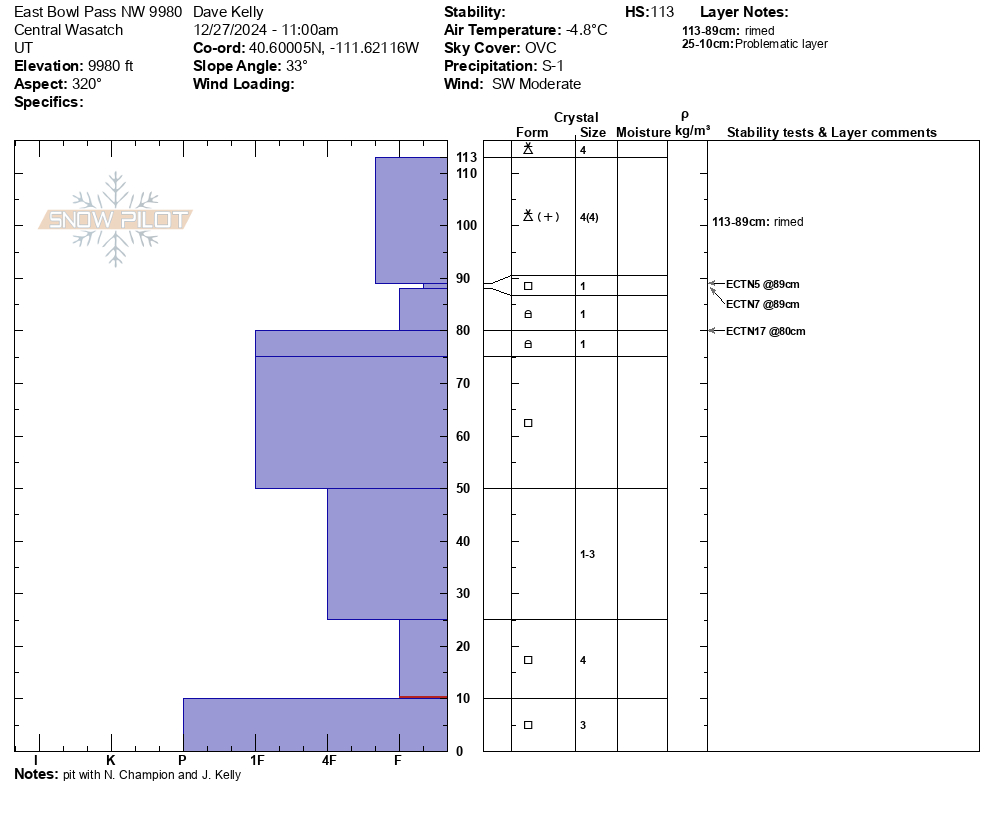
Total height of snow was 44" (113cm). We got extended column tests without propagation 3' (89cm) from the ground under the newest snow on a layer of faceted grains. This snowpack showed us very weak structure and we did not believe that where we dug had enough recent snow or wind loaded snow to be a problem just yet. As the storm moves through this danger will increase particularly if stiffer wind drifts load in on top of this weak faceted snow. The weak faceted snow (first hard) 12"" (25cm) from the surface was smooshing straight to the ground. This layer will not support much weight.

Similar snowpit location to one dug on November 14, 2024 and October 29, 2024.

We skied one north facing slope at 10,000' in elevation. This slope was less than 30 ° in steepness and it was quite eery when the first skier dropped in and the entirety of the slope collapsed and shot cracks back up towards the ridge. If this slope had been any steeper it would have been an avalanche. We talked about the low angle nature of the slope and the fact that it was not connected to, below, or directly besides another slope greater than 30 °in steepness before we skied it. As the day went on and more new snow and wind added additional weight to an already fragile snowpack, the red flags became more apparent. It was a great reminder to make conservative terrain choices on both our descent and ascent to get back home safely.
Today's Observed Danger Rating
Considerable
Tomorrows Estimated Danger Rating
High
Coordinates