Join us at our 2nd Annual Blizzard Ball

Forecast for the Salt Lake Area Mountains

Drew Hardesty
Issued by Drew Hardesty on
Tuesday morning, December 24, 2024
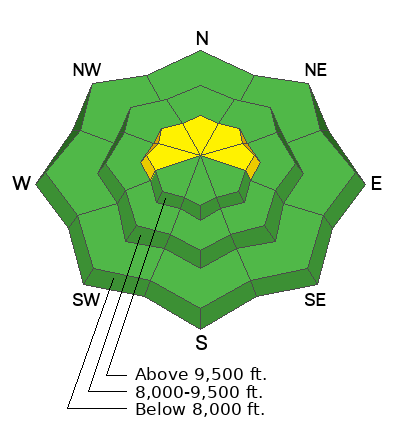
Most terrain has an overall LOW avalanche danger. Pockets of MODERATE danger, however, exist on upper-elevation slopes facing west through north through east where it is possible to trigger an avalanche 1-3 feet deep failing on a persistent weak layer of faceted snow. Carefully evaluate slopes with a deeper snowpack that have been previously wind-loaded and remain the most prone to avalanches. With strong winds from the southwest expected this afternoon, watch for and avoid any developing soft slabs around terrain features.

Heads up, any new snowfall in the coming days will add load to our poor snowpack structure and will increase the likelihood of an avalanche.
Low
Moderate
Considerable
High
Extreme
Learn how to read the forecast here
Special Announcements
Take advantage of our local shops across the state who will be handing out free Batteries for Beacons from now until February 1, 2025! All you need to do is fill out a quick survey and grab the AAA or AA batteries you need to keep your beacon fresh this season. Find participating shops and more info here.
Weather and Snow
Today's forecast is written by McKinley Talty, the UAC Education Manager. Thanks McKinley.

This morning the skies are partly cloudy and temperatures are rising. A slight temperature inversion is in place and trailhead temperatures are in the lower 20s F while ridgetop temperatures are in the lower 30s F. Winds remained light overnight (5-10 mph) and will be increasing rapidly throughout the day rising to 35-45 mph from the southwest with gusts up to 70 mph. The mountains received a skiff of snow yesterday, and we might see a few flakes begin to fall this afternoon.
An incoming storm is expected to bring snow to the region beginning this evening, and we can expect 4-8 inches of snow (0.5-0.9 inches of SWE) by tomorrow evening. Winds will decrease and shift to the NW tomorrow morning as the storm moves out of our area, bringing a short break in weather before the next system moves in. An active series of storms appears to be on track for northern Utah, beginning Thursday afternoon through the weekend, and we could be measuring snow in feet and not inches.

Recent Observations for the Central Wasatch HERE.
Recent Avalanches
No new avalanches were reported in the backcountry yesterday. The most recent backcountry avalanche occurred Saturday along the Park City ridgeline (West Monitor) on a northeast-facing slope at 9,900’ breaking 2 feet deep on a persistent weak layer of faceted snow. Last week (12/17/24) two separate avalanches were reported breaking on this persistent weak layer on upper-elevation northeast-facing terrain.
On Sunday, avalanche control work along the Park City ridgeline triggered a stubborn hard slab avalanche with heavy explosives, failing on the persistent weak layer 1.5 feet deep.

Avalanche List for the Central Wasatch HERE.
Ad
Avalanche Problem #1
Persistent Weak Layer
Type
Location
Likelihood
Size
Description
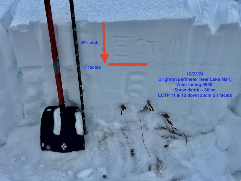
A poor snow structure with a persistent weak layer (PWL) of faceted snow exists on shady slopes at mid and upper elevations. It'll be along the higher elevation wind drifted terrain where it is possible to trigger an avalanche 1-3 feet deep and over 100 feet wide. Signs of instability such as cracking and collapsing are more obvious at mid-elevation slopes out of the wind zone.
I am uncertain if the incoming storm will tip the scales of our PWL, but I am certain every slope holding weak snow has a tipping point. Be observant and cautious as the incoming storm adds load to our weak structure.
Photo: Drew Hardesty's snowpit below highlighting our current weak structure.
General Announcements
This information does not apply to developed ski areas or highways where avalanche control is normally done. This forecast is from the U.S.D.A. Forest Service, which is solely responsible for its content. This forecast describes general avalanche conditions and local variations always occur.