Check out our Holiday Auction - Sign Up for the Utah Snow and Avalanche Workshop (USAW)

Forecast for the Salt Lake Area Mountains

Dave Kelly
Issued by Dave Kelly on
Sunday morning, December 1, 2024
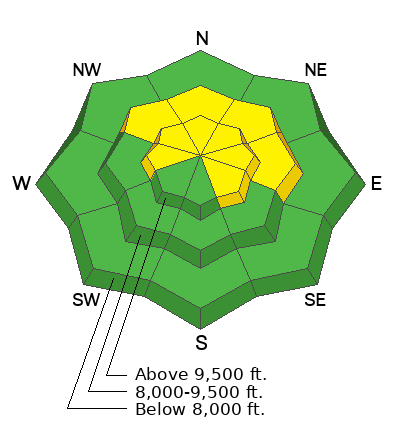
The avalanche danger is MODERATE on slopes facing northwest through north and east at the mid and upper elevations and on upper elevation southeast and west facing aspects where it may be possible to trigger an avalanche up to 2' deep and 80' wide failing on a persistent weak layer (PWL) of faceted snow. The avalanche danger is LOW on all other aspects and elevations. You may see small isolated wet loose avalanches on southerly facing slopes with daytime heating.
I will be avoiding any slope over 30° in steepness if the facets are present in the snowpack.
Low
Moderate
Considerable
High
Extreme
Learn how to read the forecast here
Special Announcements
The 17th Annual Utah Snow and Avalanche Workshop (USAW) is scheduled for Saturday December 7th - Information and tickets available here.
If you trigger or see an avalanche adjacent to the road or one of the ski areas and are sure no one was caught in the avalanche, call the nearest mountain dispatch and alert them to the situation, this will allow SAR teams to stand down, preventing them from being subjected to unnecessary hazard.
  • Salt Lake and Park City – Alta Central- (801-742-2033)
  • Canyons Resort/PCMR Dispatch- (435 -615-1911)
Quick refresher on Backcountry Emergencies and Avalanche Response HERE. You may just save a life
Weather and Snow
Under clear skies, mountain temperatures are in the low to mid 20's°F. Winds are calm at the 9,000' ridgelines and blowing from the west-northwest in the 20's gusting to the 30's MPH at the highest ridgelines.
Today, skies will be mostly clear. Temperatures will be 38-43°F and winds will blow from a northerly direction 5 gusting to 10 MPH at the 9,000 ridgelines and from the west-northwest 30 gusting to 40 MPH at the 11,000' ridgelines. The forecast looks promising for continued weakening of the snow surface on northerly facing aspects over the next week, and an inversion continues to build.
The snow surface is like a box of Cracker Jacks and you don't want to find the surprise. North facing slopes are starting to facet from the top-to-the-bottom and there are rocks and wildflowers poking through our thin snowpack in many locations. You'll find melt freeze crust on the southerly aspects in the morning that will warm up in the sun and could have the potential to turn into wet loose avalanches this afternoon. ​​​​​​ These wet loose avalanches can be avoided by staying off of sun warmed slopes.
Recent Avalanches
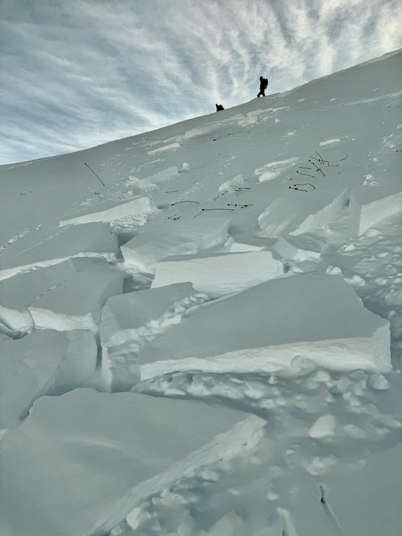
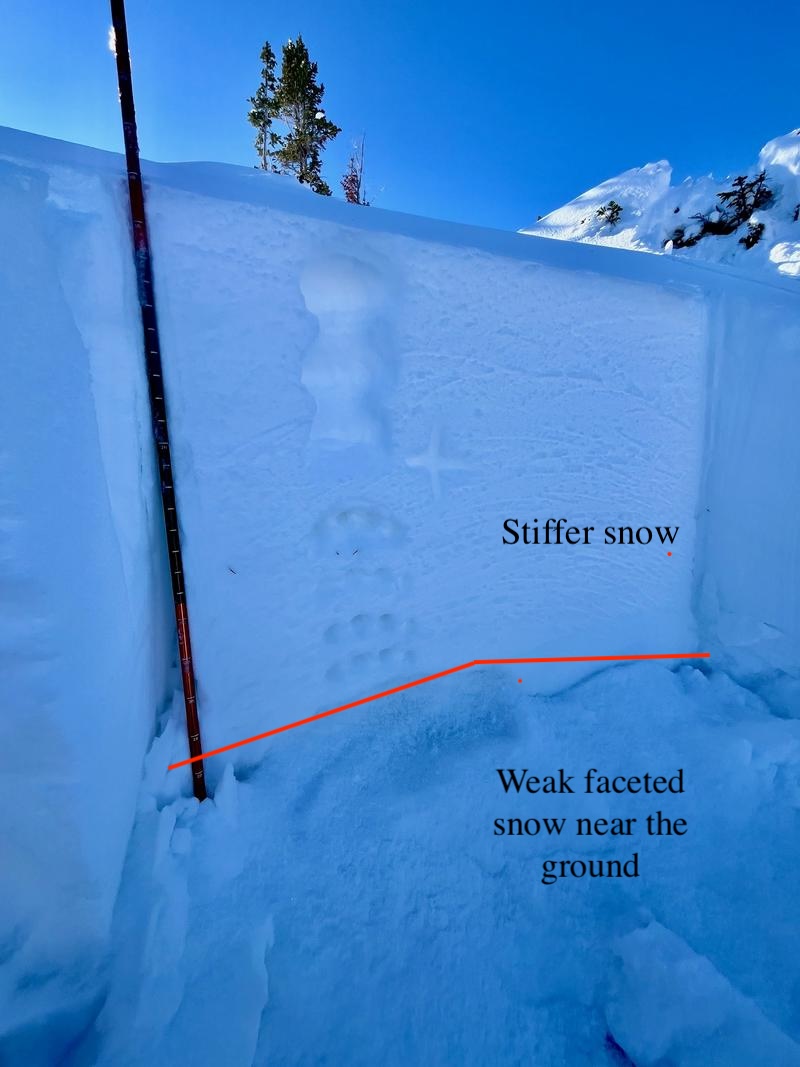
Yesterday, Bruce Tremper reported a hard slab avalanche that failed on depth hoar in South Monitor that was 12" deep and 100' wide. This persistent weak layer (PWL) avalanche had stiffer wind loaded snow on top of the facets and any slope with these features is more likely to slide. PWL avalanches are starting to stack up this week with the one consistent being the facets. Some of the slabs have been stiff (South Monitor) and some very soft (Scott's Bowl (PC Ridge)). Some have had wind in the slab (Two Dogs) and some haven't (Silver Fork). The simple way to deal with all this recent activity is to avoid slopes that have faceted snow in the snowpack (second photo showing weak faceted snow near the ground with stiffer snow over the top).
Tremper photo of South Monitor avalanche Northeast Aspect at 9,600'
Silver Fork headwall avalanche crown, north facing slope at 9,900'
Ad
Avalanche Problem #1
Persistent Weak Layer
Type
Location
Likelihood
Size
Description
Carefully assess where these buried facets may be before ascending or descending a slope greater than 30° in steepness. If you choose to venture onto slopes where this persistent weak layer (PWL) may exist, dig down and look for the structure of strong (stiffer/firmer) snow on top of weak (softer/looser) snow. If you see this structure, it may be possible to trigger an avalanche up to 2' deep and over 80' wide. As our snowpack adjusts to the most recent snow; the in-your-face nature of this problem such as cracking, collapsing, and recent avalanches will be harder to see. Any slope that has previous or current wind loading is more suspect and I would avoid these slopes.
Video of propagation with cutting (ECTPV) failing on the facets under a crust near the ground on a northeast aspect at 9,300 (video Grainger).
General Announcements
This information does not apply to developed ski areas or highways where avalanche control is normally done. This forecast is from the U.S.D.A. Forest Service, which is solely responsible for its content. This forecast describes general avalanche conditions and local variations always occur.