AVALANCHE WARNING!! Tap for info

Forecast for the Uintas Area Mountains

Craig Gordon
Issued by Craig Gordon on
Thursday morning, March 28, 2024
Active weather returns to the Uinta zone today and the avy danger rises accordingly-
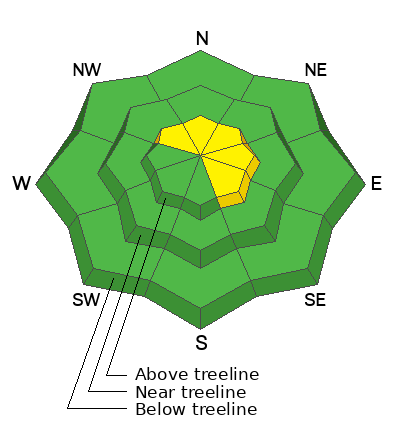
With strong winds and a good shot of snow headed our way, the avalanche danger rises to MODERATE, particularly in the wind zone, above treeline. By late in the day, human triggered avalanches are POSSIBLE, especially on steep, upper elevation, wind drifted slopes facing the north half of the compass.
Shady, wind sheltered terrain at mid and low elevations as well as most slopes facing the south half of the compass offer LOW avalanche danger and human triggered avalanches are UNLIKELY.

Low
Moderate
Considerable
High
Extreme
Learn how to read the forecast here
Special Announcements
Please help support the UAC rebuild our website backend platform to ensure the ongoing security of the website and the data stored on the site by donating to our spring campaign. Save lives by making a donation today!
Weather and Snow
Nowcast- Southerly winds bumped into the 20's and 30's late yesterday afternoon and continue in that spirit this morning at o'dark thirty. Meanwhile, under a veil of thick clouds, temperatures register in the mid teens and upper 20's, or about 10 degrees warmer than yesterday at this time. Yup... it's the warm before the storm. Riding and turning conditions are a mixed bag. On the south half of the compass you'll find varying degrees of suncrust, while soft, settled snow still exists on wind sheltered shady slopes.
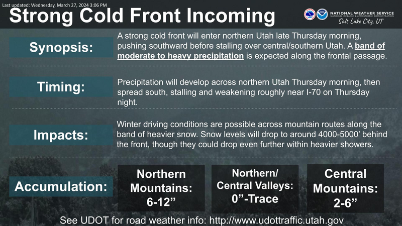
Forecast- A solid looking cold front is slated to slide through the area later this afternoon. Until the storm arrives we can expect mostly cloudy skies, with strong winds blowing into the 40's and 50's from the west and southwest near the high peaks. Temperatures climb into the mid 30's and crash into the teens overnight along with a blast of intense snowfall. I think 4"-8" is a good bet by Friday morning.
Futurecast- A slight break in the action for Friday morning, but more unsettled weather comes back to visit Friday afternoon and evening, ushering in a few more inches of snow with scattered showers lingering into Saturday. The next storm in the queue rolls through on Sunday into early Monday.
Our good friends and partners at the National Weather Service in the City of Salt, have hoisted a Winter Weather Advisory for the western Uinta zone.
Recent Avalanches
Most likely occurring early Wednesday morning when 4" of snow stacked up in about an hour, our man with the Weber Canyon plan, Trevor Katz, spotted this slide on a steep, wind drifted slope in Upper Chalk Creek.
Micheal J found similar evidence of a recent avy cycle in the Hoyt environs yesterday.

For all Uinta observations and archived avalanche activity click HERE.
Ad
Avalanche Problem #1
Wind Drifted Snow
Type
Location
Likelihood
Size
Description
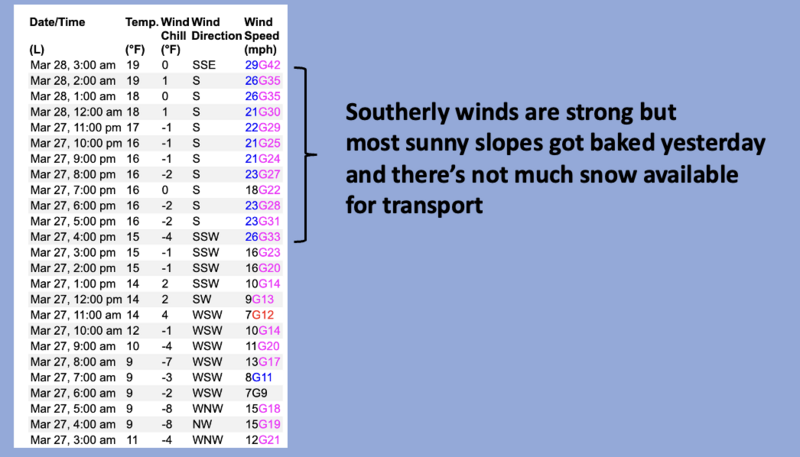
Image above, 24 hour data dump from Windy Peak (10,662')
Much of our south facing terrain took on heat and got shrink-wrapped yesterday and there's not much snow available to blow around. But of course, wind has a funny way of channeling the remaining scraps of dry snow through terrain features and I suspect there's a drift or two lurking on the leeward side of upper elevation ridges. However, until today's storm kicks into gear, you'd really have to go hunting for a drift that reacts to our additional weight. Nonetheless... it's a day of evolving weather and changing avalanche conditions and that shifts the equilibrium later today once the storm arrives.
Additional Information
The Uinta weather station network was upgraded this summer and all that real-time info is found HERE. Simply click on "western Uinta" tab and then "weather stations" tab.

We are always looking for snow and avalanche observations or just general riding conditions. So... if you see something, say something. You can reach me directly at [email protected] or 801-231-2170.
Also, if you're looking for more avy education opportunities for yourself, your crew, or your club please don't hesitate to reach out to me and we'll find a presentation, class, or clinic for ya!
General Announcements

Issued at 03:30 on Thursday, March 28th this forecast will be updated by 0700 Friday, March 29th, 2024.
This forecast is from the U.S.D.A. Forest Service, which is solely responsible for its content. This forecast describes general avalanche conditions and local variations always occur.