Join us for the 17th Annual Professional Snow and Avalanche Workshop (PROSAW) on November 4 - Purchase tickets here!

Forecast for the Uintas Area Mountains

Craig Gordon
Issued by Craig Gordon on
Wednesday morning, February 21, 2024
A little short-term pain leads to long-term gain... so let's not take our eyes off the prize as we get closer to the finish line-
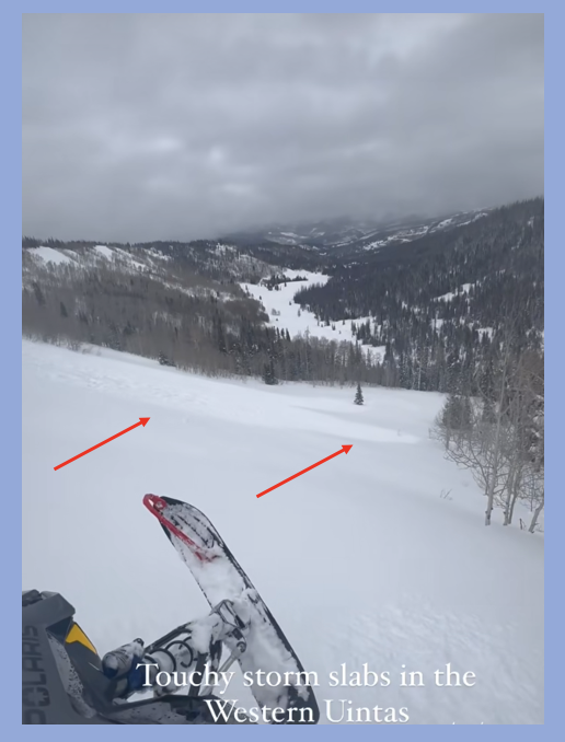
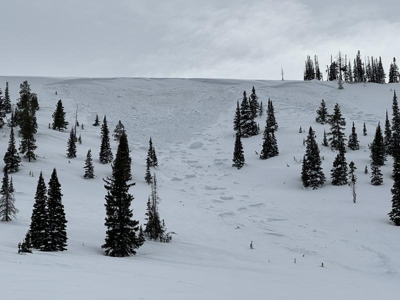
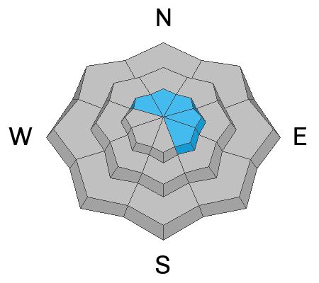
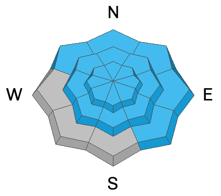
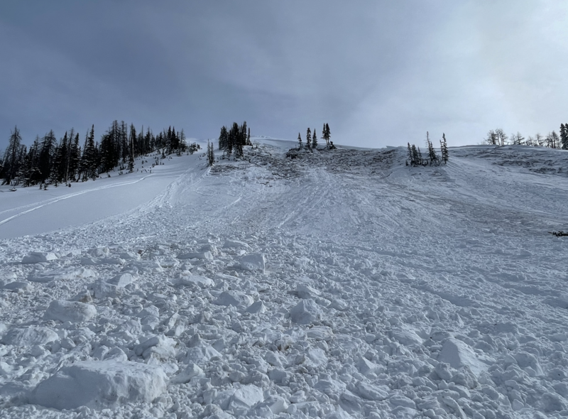
At and above treeline, you'll find CONSIDERABLE avalanche danger. Human triggered avalanches are LIKELY, especially on steep, wind drifted slopes facing the north half of the compass. Remember, we're not out of the woods with older layers, particularly in steep, rocky terrain. Any slide triggered has the potential to fail on weaker layers of snow, now buried deeply in the snowpack and that'll deliver a season ending avalanche.
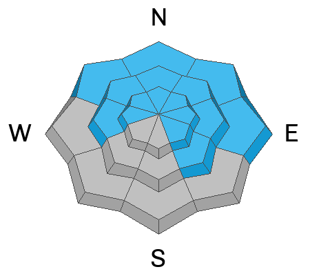
In addition, several weak layers varying in thickness, strength, and characteristic lurk in the snowpack near and below treeline around the compass where you'll encounter MODERATE avalanche danger and human triggered slides are POSSIBLE on all aspects.

Here's your exit strategy-
You wanna avoid avalanches completely? Well, you came to the right place!
The Uintas have plenty of roly-poly, low elevation, low angle terrain, especially slopes facing the south half of the compass where you'll find LOW avalanche danger
Low
Moderate
Considerable
High
Extreme
Learn how to read the forecast here
Special Announcements
We are seeking a passionate individual to join us as Executive Director of the nonprofit Utah Avalanche Center. Click here for more information.
Also... please join the UAC and Inspired Summit Adventures for the grand opening of our new Transceiver Training Park at Pinebrook, Sunday, February 25, from 3:00-6:00PM.
Weather and Snow
Nowcast- The road goes on forever and the party never ends... as yet a couple more inches of snow stack up overnight. 24 hour storm totals edge close a foot of snow with just about an inch of H2O. After a late-in-the-day Tuesday lull, ridgetop winds blowing from the south and southwest ramped up into the 30's overnight and continue in that spirit early this morning. Mostly cloudy skies at o'dark thirty deliver light snow showers, while rather warm temperatures bump the mercury into the low 30's near the trailheads and mid 20's with a little elevation gain. A bit of green-housing yesterday shrink-wrapped lower elevation terrain, but grab a little vertical relief and you'll be rewarded with cold, creamy snow on a go-anywhere base.
Forecast- Look for mostly cloudy skies with scattered snow showers and temperatures not climbing much from where we're at this morning. Winds switch to the west and blow into the 30's by early afternoon, ushering in a cold front and better chance of accumulating snow. Nothing to get too excited about, though an additional 2"-4" of lower density snow seems like a good bet.
Futurecast- After one last shot of snow tonight, I think we begin drying out and a clearing trend has its sights set to wrap up the workweek.

Recent Avalanches
From yesterday, above the Mill Hollow reservoir... the caption says it all.
On Monday, avy-savvy, Inspired Summit Adventure guide Wes Shirey noted yet another large, natural slide near Wolf Creek in Neeley Bowl. Southerly winds light this place up and yesterday was no exception. Breaking 4' deep and 200' wide, this slide is a repeater and failed on weak, old, sugary snow. More deets found HERE.

For all Uinta observations and recent avalanche activity click HERE.
Ad
Avalanche Problem #1
Wind Drifted Snow
Type
Location
Likelihood
Size
Description
24 hour data dump from Windy Peak (10,662')
Yesterday's maritime-esque, damp, clammy weather helped throw a cargo net over much of the storm snow available for transport and I was surprised how unreactive fresh wind drifts were to my additional weight. However, the nautical weather kept me from getting into the alpine were I bet it's a different story as there's colder snow available to blow around. With an uptick in winds, I suspect a new round of fresh drifts formed overnight. Found mostly on the leeward side of upper elevation ridges, I wouldn't be too surprised to find a drift or two around terrain features like chutes or gully walls.
Avalanche Problem #2
New Snow
Type
Location
Likelihood
Size
Description
Recent new snow stacks up on a variety of old snow surfaces and is becoming more reactive as it settles into a cohesive storm slab. Marks highlights the situation above.
The new snow that piled up since early February may fracture and produce a slab avalanches 1-3 feet deep. On Sunday, riders near Wall Lake triggered many shallow soft slabs as they wisely tested small slopes to get information about conditions. As more snow stacks up today, new snow slabs dot the landscape and may become more reactive to our additional weight, especially as the day wares on .
On shaded slopes, there is layer of buried surface hoar about 3 feet deep. It is not everywhere; however, Mark found it last weekend near Smith and Morehouse and on Saturday near Iron Mine Mountain.We haven't gotten any reports of avalanches on this layer, but it's hard to ignore.
On sunny slopes, there may be a thin layer of facets on top of an heat crust that was buried 12"-18" deep on Valentine's day. We still need to hunt for this layer and could use your help... so let us know what your finding. However, with widespread avalanche activity on this layer in other places as well as two suspicious slides near Long Lake, we consider it guilty until proven otherwise.
Avalanche Problem #3
Persistent Weak Layer
Type
Location
Likelihood
Size
Description
Old layers of faceted snow near the ground can still produce a hard slab avalanche like this one last weekend in upper Chalk Creek
Even though the odds of triggering one of these slides have gone way down, the consequences remain severe. Common terrain theme is.... steep, rocky, north facing terrain with a thin, weak snow pack are likely suspects. You can trigger a deep, nasty slide form a thin portion of the snowpack like around a rock or bush, barely hidden under the snow.
Becoming more the exception of the rule, I wouldn't take my eyes of the prize... once triggered, these are season ending avalanches
Additional Information
The Uinta weather station network was upgraded this summer and all that real-time info is found HERE. Simply click on "western Uinta" tab and then "weather stations" tab.

We are always looking for snow and avalanche observations or just general riding conditions. So... if you see something, say something. You can reach me directly at [email protected] or 801-231-2170.
Also, if you're looking for more avy education opportunities for yourself, your crew, or your club please don't hesitate to reach out to me and we'll find a presentation, class, or clinic for ya!
General Announcements

Issued at 0400 on Wednesday, February 21st this forecast will be updated by 0700 Thursday, February 22nd, 2024.
This forecast is from the U.S.D.A. Forest Service, which is solely responsible for its content. This forecast describes general avalanche conditions and local variations always occur.