Join us for the 17th Annual Professional Snow and Avalanche Workshop (PROSAW) on November 4 - Purchase tickets here!

Forecast for the Moab Area Mountains

Eric Trenbeath
Issued by Eric Trenbeath on
Monday morning, February 5, 2024
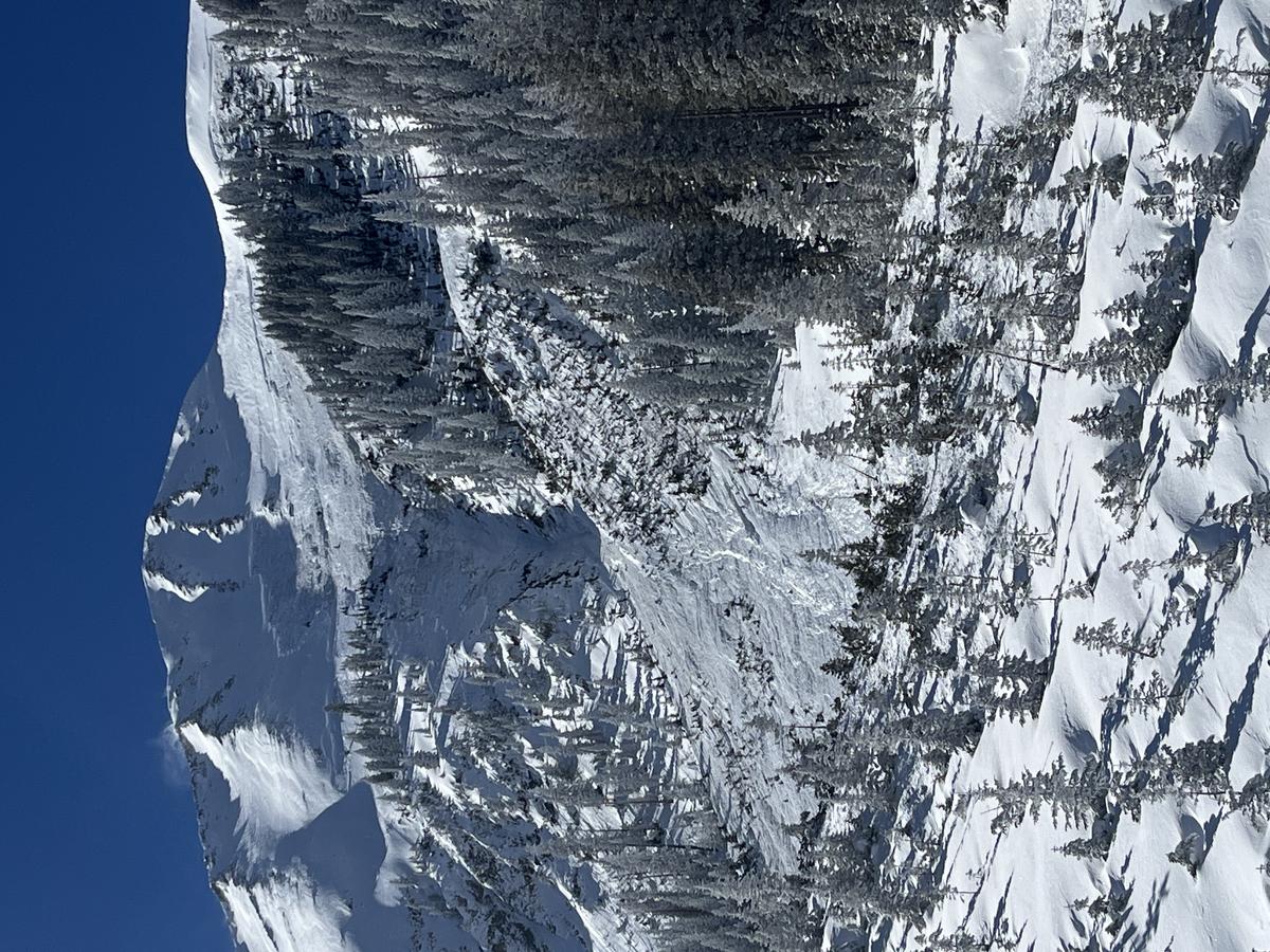
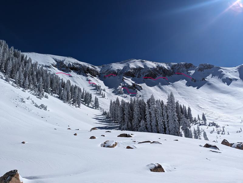
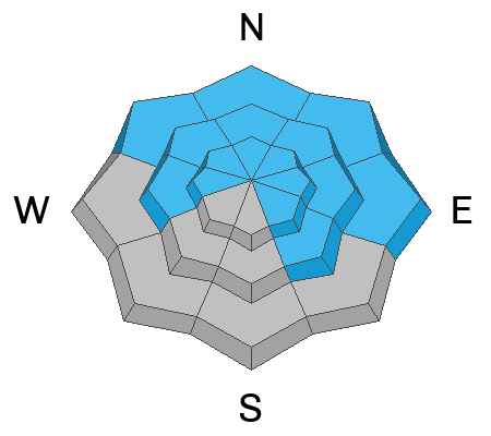
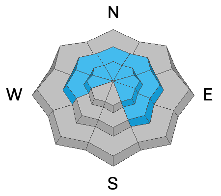
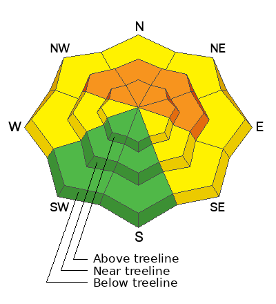
A CONSIDERABLE avalanche danger exists on steep northerly aspects near and above treeline. In these areas, slabs of wind drifted snow have overloaded an already stressed, buried persistent weak layer, and deep and dangerous human triggered avalanches are likely.
A MODERATE avalanche danger exists on steep slopes facing W and SE, and on lower elevation, northerly aspects. Deep and dangerous, human triggered avalanches failing on a buried persistent weak layer are possible in these areas. Likely trigger points are thinner snowpack areas along slope margins, shallow convexities, and areas of steep, rocky, radical terrain.

Most S and SW facing terrain offers LOW danger.
Low
Moderate
Considerable
High
Extreme
Learn how to read the forecast here
Special Announcements
Road Conditions: The Geyser Pass Road will be closed for plowing this morning. Plan on being through the gate by 9:00 if you want to beat them.
Grooming: Trails saw a lot of traffic yesterday, but Gold Basin was groomed with classic track.
Weather and Snow
6:00 a.m. Snow and Weather Data
24 Hour Snow 0" 72 Hour Snow 7" Season Total Snow 107" Depth at Gold Basin 46"
Winds on Pre-Laurel Peak: S 20-25 G35 Temp 28˚ Percentage of Normal 104%

Weather
Winds from the south have been on the increase since last evening averaging 20-25 mph along ridge tops since about 8:00 p.m. Warm and breezy conditions are on tap today ahead of a long wave trough over the eastern Pacific. Strong southerly flow and increasing clouds tonight will drive mild temps into Tuesday as the storm moves into the region. Snow showers should develop sometime tomorrow afternoon with the greatest intensity early Wednesday morning. Up to a foot of heavy, dense snow seems likely. Snow from this storm should continue into Thursday, with an unsettled pattern remaining through the weekend.
General Conditions
In our travels into Gold Basin yesterday, our party came upon the debris of a very large avalanche that had run off the NE Face of Mount Tukno. This avalanche appeared to be human triggered, driving home in a very sober way what it means when we have a persistent weak layer problem. We also observed many other natural avalanches that ran during the storm on Friday night. Although we expected some activity from the Thursday-Friday storm, I did not expect 11" of snow containing 1.4" of Snow Water Equivalent, with little to no wind, to have such a widespread impact. Avalanches were observed on slopes facing W-N-E. Overnight winds have been blowing and drifting snow on to northerly aspects, further stressing already dangerous slopes. These areas are not to be messed with and the danger will only increase over the next several days. That said, excellent turning and riding can still be found on sheltered, low angle, northerly facing terrain.
Travis Nauman and company were out and about taking advantage of stable snow and good conditions on southerly aspects yesterday. Unfortunately wind and yesterday's sunshine have put the kabosh on that for today. They also documented widespread natural activity in Gold Basin. Read their excellent report here.
Snowpack and Weather Data
Gold Basin Storm Stake (10,000')
Gold Basin SNOTEL site (10,000')
SNOTEL site near Geyser Pass Winter Trailhead (9600')
Wind Station on Pre-Laurel Peak (11,400')
NWS forecast for the La Sal Mountains.
Recent Avalanches
Photo of the large avalanche we encountered off the NE face of Mount Tukno. Read the full report here.
Widespread natural activity in Talking Mountain Cirque in upper Gold Basin as reported by Travis Nauman.
Ad
Avalanche Problem #1
Persistent Weak Layer
Type
Location
Likelihood
Size
Description
As evidenced by the above avalanches, persistent weak layers of faceted snow continue to plague our snowpack on slopes facing W-N-E-SE, with the greatest danger existing on steep, wind loaded, northerly aspects. I don't think there is much more to say about it. Steep, northerly facing slopes near and above treeline should unequivocally be avoided. On West and Southeast aspects, and on lower elevation northerlies, it's a bit more a roll of dice, but deep and dangerous, human triggered avalanches remain possible in these areas. The way things are, and with the upcoming storm system, the best plan is to sit tight and avoid slopes steeper than 30 degrees that face W-N-E-SE.
Avalanche Problem #2
Wind Drifted Snow
Type
Location
Likelihood
Size
Description
Overnight southerly winds have blown and drifted snow on to northerly aspects further loading already stressed persistent weak layers. In and of themselves, these fresh slabs of wind drifted snow should present identifiable, and avoidable problems. But the real issue here is the likelihood for triggering a much deeper and more dangerous avalanche on slopes where they are located. Travel advice remains the same, avoid steep slopes facing W-N-SE.
Additional Information
Want some more insight into the La Sal Mountains as well as the communal impacts of a tragic avalanche? Check out the latest UAC podcast with forecaster Eric Trenbeath where he discusses the range, it's often treacherous snowpack, and how the devastating avalanche in February, 1992, affected the Moab community.
Our avalanche beacon checker sign and beacon training park are up and running. A huge thanks to Talking Mountain Yurts for sponsoring those this season!
Sign up for forecast region-specific text message alerts. You will receive messages about changing avalanche conditions, watches, warnings and road plowing closures.
Follow us on Instagram @utavy_moab
General Announcements
This forecast is from the U.S.D.A. Forest Service, which is solely responsible for its content. This forecast describes general avalanche conditions and local variations always occur.