Forecast for the Moab Area Mountains

Dave Garcia
Issued by Dave Garcia for
Tuesday, February 6, 2024
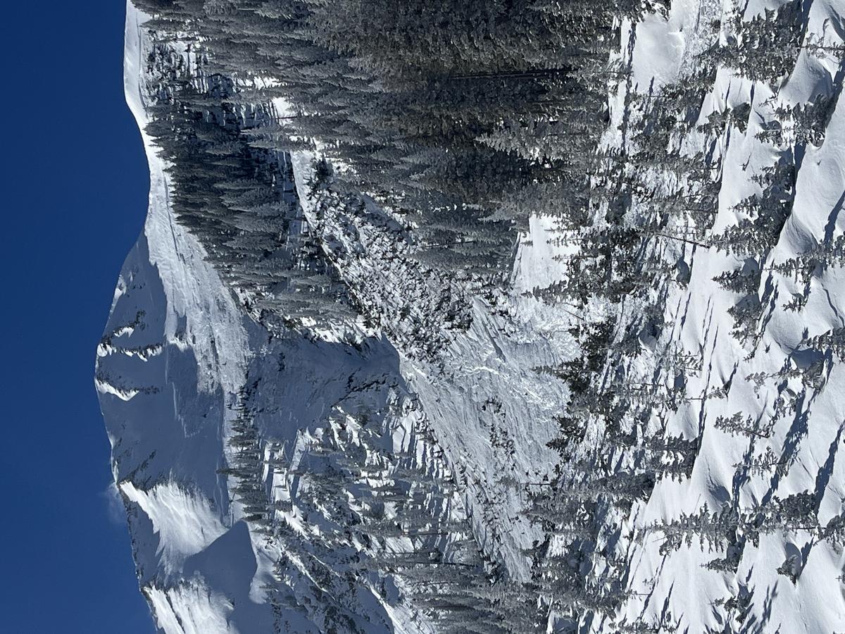
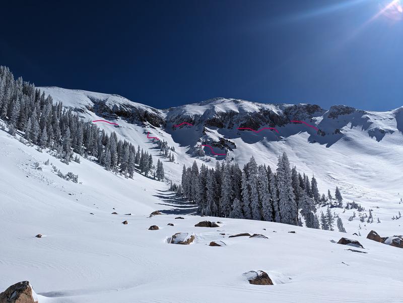
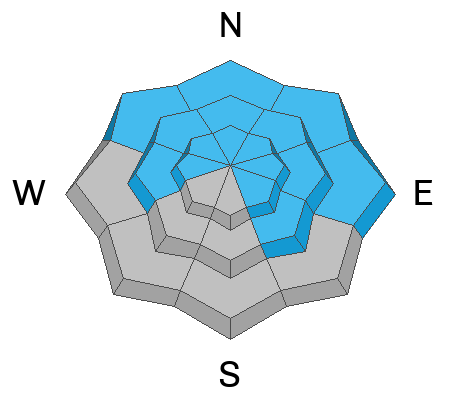
The avalanche danger is CONSIDERABLE on steep slopes that face NW-N-NE-E for triggering deep and dangerous avalanches 3-6 deep failing on a buried persistent weak layer (PWL). Human-triggered avalanches are LIKELY on these slopes. The PWL also exists on slopes that face W and SE and lower elevation Northerly aspects. On these slopes, the avalanche danger is MODERATE, and large, destructive avalanches remain POSSIBLE.
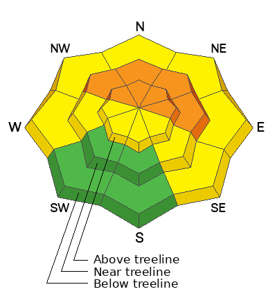
Strong southerly winds are creating fresh slabs of wind-drifted snow that will be reactive to the weight of skiers and riders. Backcountry travelers will encounter reactive drifts on all aspects above treeline and on leeward slopes near treeline.
Heads-up! A strong atmospheric river event will impact the La Sals tonight and avalanche danger will be on the rise.
Low
Moderate
Considerable
High
Extreme
Learn how to read the forecast here
Special Announcements
Road Conditions: The Geyser Pass Road was plowed on Monday. The road remains slick and snow-covered, AWD and good tires are recommended
Grooming: Trails were last groomed on Sunday.
Weather and Snow
6:00 a.m. Snow and Weather Data
24 Hour Snow 0" 72 Hour Snow 0" Season Total Snow 107" Depth at Gold Basin 45"
Winds on Pre-Laurel Peak: SSE 36 G48 Temp 35

Weather
It's the warm before the storm, 35 degrees in Gold Basin this morning. The mercury will hover right around the freezing mark today. Strong Southerly winds will blow ahead of the storm today. The Pre-Laurel Peak anemometer shows winds hammering out of the SSE. Throughout the day the winds will shift to due South and blow in the 30's with gusts up to 45 mph. Skies will be overcast with light snow. No real accumulation during the day today, but snowfall will increase tonight. An atmospheric river event (AR) will keep our region in a prolonged deep southerly flow. Warm temperatures will keep snow levels initially as high as 8,000 ft, which means the storm will start with fairly wet and dense snow. By Wednesday, colder temps move in and snow levels drop to around 5,500 ft. The highest precipitation rates will occur on Wednesday. We can expect 3-6" of snow tonight. I'll have Wednesday's numbers sorted by tomorrow's update. Precipitation Intensity (PI) wanes Wednesday night into Thursday and the flow shifts to the Northwest. Once we get past Thursday the pattern remains quite active and unsettled for the remainder of the week and into the weekend. Intermittent periods of light to moderate snowfall continue through Saturday.
General Conditions
It's been a bit of a powder party the last few days, but strong Southerly winds will put a damper on that. In my travels yesterday I noticed Southerly aspects were crusted over by Sunday's strong sunshine. Exposed terrain will be heavily wind-affected. Skiers and riders will need to seek sheltered terrain in the trees today to find soft snow. Fresh soft slabs of wind-drifted snow will be developing on all aspects above treeline. Wind speeds are strong enough that these slabs will develop on leeward slopes near treeline as well. Our primary avalanche concern remains a persistent weak layer of facets that is buried 2 to 3 feet below the surface. Widespread avalanche activity over the weekend is evidence of just how sensitive this weak layer is. Both human-triggered and natural avalanches ran deep and wide this weekend on slopes facing W-N-E. Skiers and riders should avoid slopes steeper than 30 degrees.
Snowpack and Weather Data
Gold Basin Storm Stake (10,000')
Gold Basin SNOTEL site (10,000')
SNOTEL site near Geyser Pass Winter Trailhead (9600')
Wind Station on Pre-Laurel Peak (11,400')
NWS forecast for the La Sal Mountains.
Recent Avalanches
Photo of the large avalanche observed on Sunday off the NE face of Mount Tukno. Read the full report here.
Widespread natural activity in Talking Mountain Cirque in upper Gold Basin as reported by Travis Nauman.
All of these avalanches broke deep on the buried persistent weak layer.
Ad
Avalanche Problem #1
Persistent Weak Layer
Type
Location
Likelihood
Size
Description
The biggest indicator of avalanche danger is recent avalanches. This weekend's widespread natural and human-triggered avalanche cycle is a huge red flag, and it tells us just about everything we need to know. The persistent weak layer (PWL), buried 2 to 3 feet below the surface, is still very sensitive and continues to produce avalanches. These avalanches are large, dangerous, and deadly. They are 3 feet deep on average, and up to 6 feet deep in areas that have been previously loaded by wind-drifted snow. The recent avalanche activity alone is enough to keep me from traveling on any slope steeper than 30 degrees that harbors a buried PWL. This weak layer exists on slopes that face W-N-E-SE.
Avalanche Problem #2
Wind Drifted Snow
Type
Location
Likelihood
Size
Description
The last 12 hours of winds on Pre-Laurel Peak tell the story. Strong Southerlies today will continue to strip all of that soft powder we have been enjoying, and blow it onto leeward slopes near treeline and above. Sensitive soft slabs of wind-drifted snow will be most pronounced on slopes that face W-N-E. Strong winds have the ability to load all aspects and blowing and drifting snow will create slabs above treeline on the lee side of exposed ridges and in and around terrain features.
Blowing and drifting snow will continue to stress the buried persistent weak layer. Any avalanche triggered in recent wind-drifted snow has the ability to step down to the PWL, causing a deeper and much more dangerous avalanche.
Additional Information
Want some more insight into the La Sal Mountains as well as the communal impacts of a tragic avalanche? Check out the latest UAC podcast with forecaster Eric Trenbeath where he discusses the range, it's often treacherous snowpack, and how the devastating avalanche in February, 1992, affected the Moab community.
Our avalanche beacon checker sign and beacon training park are up and running. A huge thanks to Talking Mountain Yurts for sponsoring those this season!
Sign up for forecast region-specific text message alerts. You will receive messages about changing avalanche conditions, watches, warnings and road plowing closures.
Follow us on Instagram @utavy_moab
General Announcements
This forecast is from the U.S.D.A. Forest Service, which is solely responsible for its content. This forecast describes general avalanche conditions and local variations always occur.