Join us at our 2nd Annual Blizzard Ball

Forecast for the Moab Area Mountains

Eric Trenbeath
Issued by Eric Trenbeath on
Sunday morning, February 4, 2024
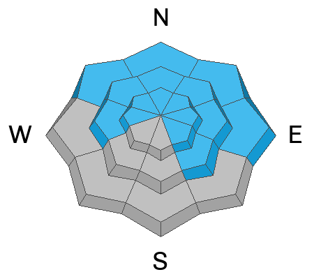
The avalanche danger remains CONSIDERABLE on steep northerly aspects above treeline. In these areas, slabs of recent and wind drifted snow have added stress to buried persistent weak layers, increasing the likelihood for deeper and more dangerous human triggered avalanches.
Most other terrain on the N side of the compass has MODERATE danger including slopes facing W and SE near and above treeline. Avalanches failing on a persistent weak layer are possible in these areas. Likely trigger points are thinner snowpack areas along slope margins, shallow convexities , and areas of steep, rocky, radical terrain.
Most S and SW facing terrain offers LOW danger.
Low
Moderate
Considerable
High
Extreme
Learn how to read the forecast here
Special Announcements
Road Conditions: The Geyser Pass Road has not be plowed. Frozen ruts exist on the lower end with a few inches of new and wind drifted snow on the upper. 4x4 required.
Grooming: Gavin groomed all trails with his snowcat yesterday.
Weather and Snow
6:00 a.m. Snow and Weather Data
24 Hour Snow 1" 72 Hour Snow 7" Season Total Snow 107" Base Depth at Gold Basin 47"
Winds on Pre-Laurel Peak: W 5-10 TempPercent of Normal 104

Weather
Under clear skies, temperatures have plummeted into the single digits. It's going to be a beautiful winter day up there with sunny skies, high temps in the upper 20's, and light westerly winds. Get it while you can before the next Atmospheric River starts feeding moisture into the area Tues-Wed. This looks to be a long duration system bringing periods of snow through the end of the week.
General Conditions
Fresh snow, sunny skies, cool mountain temperatures, and little to no wind promise an all time day up in the La Sals. Close to a foot of snow has fallen since Thursday night and conditions are excellent. By and large, we've seen very little slabbing within this most recent snow. Winds have been remarkably well behaved although some drifting on to northerly aspects occurred early in the cycle. Steep, northerly facing slopes remain our primary area of concern. Avalanches triggered in these areas could break down to a buried persistent weak layer resulting in a much deeper and more dangerous avalanche.
Sam Van Wetter was out stomping around in the South Mountain hinterlands yesterday and he reported collapsing at very low elevations where the snowpack is extremely thin. These areas are generally below the elevation of where you will find good skiing and riding terrain, but this is a good reminder of the weak snow that exists at the base of the snowpack. Thinner snowpack areas along slope margins, wind swept convexities, or areas of rocky, radical terrain are likely trigger points for avalanches breaking into this weak snow.
Snowpack and Weather Data
Gold Basin Storm Stake (10,000')
Gold Basin SNOTEL site (10,000')
SNOTEL site near Geyser Pass Winter Trailhead (9600')
Wind Station on Pre-Laurel Peak (11,400')
NWS forecast for the La Sal Mountains.
Ad
Avalanche Problem #1
Persistent Weak Layer
Type
Location
Likelihood
Size
Description
Persistent weak layers of faceted snow exist 2'-3' deep in the snowpack on slopes facing W-N-E-SE. Stability tests over the past week to 10 days have shown them to either be gaining strength, or simply harder to affect through the depth of the overriding slab. Thinner snowpack areas are likely trigger points for avalanches failing on these buried weak layers. On steep, upper elevation, northerly aspects, slabs of recent and wind drifted snow have added stress to these weak layers increasing the likelihood for a deep and dangerous avalanche. Continue to avoid steep, upper elevation, northerly aspects today.
Additional Information
Want some more insight into the La Sal Mountains as well as the communal impacts of a tragic avalanche? Check out the latest UAC podcast with forecaster Eric Trenbeath where he discusses the range, it's often treacherous snowpack, and how the devastating avalanche in February, 1992, affected the Moab community.
Our avalanche beacon checker sign and beacon training park are up and running. A huge thanks to Talking Mountain Yurts for sponsoring those this season!
Sign up for forecast region-specific text message alerts. You will receive messages about changing avalanche conditions, watches, warnings and road plowing closures.
Follow us on Instagram @utavy_moab
General Announcements
This forecast is from the U.S.D.A. Forest Service, which is solely responsible for its content. This forecast describes general avalanche conditions and local variations always occur.