Forecast for the Moab Area Mountains

Eric Trenbeath
Issued by Eric Trenbeath for
Saturday, February 3, 2024
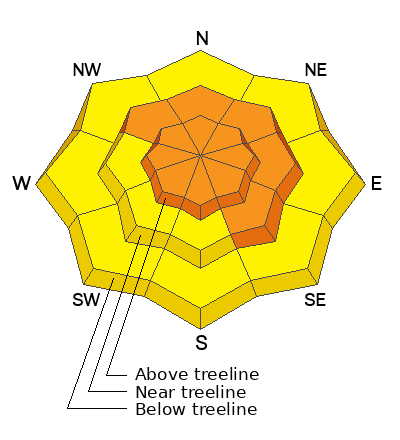
The avalanche danger is CONSIDERABLE on steep slopes that face NW-N-SE near and above treeline, and on all aspects above treeline. Human triggered soft slab avalanches involving new and wind drifted snow are likely. On slopes facing NW-N-SE, the new snow has added stress to buried persistent weak layers, increasing the likelihood for deeper and more dangerous human triggered avalanches.
All other terrain has a MODERATE danger and soft slab avalanches involving the most recent storm snow are possible.
Choose terrain wisely today. Look for signs of instability such as cracking in the snow surface and avoid steep slopes facing NW-N-SE.
Low
Moderate
Considerable
High
Extreme
Learn how to read the forecast here
Special Announcements
Road Conditions: The Geyser Pass Road has not be plowed. Frozen ruts exist on the lower end with a few inches of new and wind drifted snow on the upper. 4x4 required.
Grooming: Trails will be covered in fresh snow.
Weather and Snow
6:00 a.m. Snow and Weather Data
24 Hour Snow 6" 72 Hour Snow 11" Season Total Snow 106" Base Depth at Gold Basin 47"
Winds on Pre-Laurel Peak: NW 5-10 Temp 21˚ F

Weather
A low pressure trough over the CO/NM border will continue to influence regional weather but the activity will be to the north and east of us. Today, look for mostly cloudy skies, winds from the NW increasing to 20 mph along ridge tops, and high temps in the low 20's. Sunday looks to be the only sunny day of the upcoming week, with another Atmospheric River poised to deliver the next round of snow Tue-Wed.
General Conditions
11" of new snow is surely nothing to complain about but it was far less than forecasted, and conditions yesterday were not as dangerous as I anticipated. Out of the gate we only had 6" of new snow with intermittent light snow showers that picked up by afternoon. We found excellent skiing in sheltered areas, with pretty good skiing in more exposed terrain. With an additional 5" it will be even better today. We only observed minor slabbing in the new snow but increasing winds today will likely stiffen it up a bit. Soft slab avalanches up to a foot deep will be possible on steep slopes on all aspects today. Signs of instability include cracking in the snow surface or blocks of snow between your skis. On northerly aspects near treeline and above, deeper drifts have formed adding stress to buried persistent weak layers. Avalanches triggered in these areas could break deep and wide resulting in an un-survivable avalanche.
Snowpack and Weather Data
Gold Basin Storm Stake (10,000')
Gold Basin SNOTEL site (10,000')
SNOTEL site near Geyser Pass Winter Trailhead (9600')
Wind Station on Pre-Laurel Peak (11,400')
NWS forecast for the La Sal Mountains.
Ad
Avalanche Problem #1
Persistent Weak Layer
Type
Location
Likelihood
Size
Description
New and wind drifted snow will add stress to buried persistent weak layers in the snowpack increasing the likelihood for deep and dangerous, human triggered avalanches. In some areas we may even see some natural activity although I don't think we've had enough of a load for a full cycle. The greatest danger for this type of avalanche exists on steep slopes near and above treeline that face NW-N-SE and slopes steeper than 30 degrees with these aspects should be avoided.
Avalanche Problem #2
New Snow
Type
Location
Likelihood
Size
Description
Soft slab avalanches within the most recent storm snow are possible on all aspects. Signs of instability include cracking in the snow surface and blocks of snow between your skis indicating that a slab has formed. Utilize test slopes on these aspects and look for signs of instability before committing to steeper terrain. On northerly facing slopes, new and drifted snow will increase then likelihood for deeper and dangerous, human triggered avalanches. All, steep, northerly facing terrain should be avoided.
Additional Information
Want some more insight into the La Sal Mountains as well as the communal impacts of a tragic avalanche? Check out the latest UAC podcast with forecaster Eric Trenbeath where he discusses the range, it's often treacherous snowpack, and how the devastating avalanche in February, 1992, affected the Moab community.
Our avalanche beacon checker sign and beacon training park are up and running. A huge thanks to Talking Mountain Yurts for sponsoring those this season!
Sign up for forecast region-specific text message alerts. You will receive messages about changing avalanche conditions, watches, warnings and road plowing closures.
Follow us on Instagram @utavy_moab
General Announcements
This forecast is from the U.S.D.A. Forest Service, which is solely responsible for its content. This forecast describes general avalanche conditions and local variations always occur.