Check out our Holiday Auction - Sign Up for the Utah Snow and Avalanche Workshop (USAW)

Forecast for the Logan Area Mountains

Toby Weed
Issued by Toby Weed on
Sunday morning, February 4, 2024
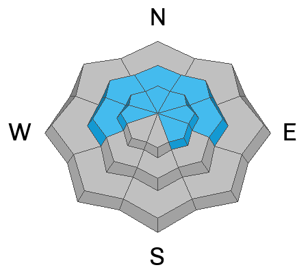
The danger is MODERATE. Heightened conditions exist in exposed upper and mid-elevation terrain. Drifting by wind blowing from the west created shallow slabs of wind-drifted snow that could be easily triggered by people on slopes steeper than 30°. Although increasingly unlikely, dangerous hard slab avalanches failing on a buried sugary, persistent weak layer are possible in isolated terrain with shallow snow cover.
Evaluate snow and terrain carefully. Avoid steep drifted slopes where you might be carried by small avalanches into terrain traps below, like trees, cliff bands, or gullies.
Low
Moderate
Considerable
High
Extreme
Learn how to read the forecast here
Special Announcements
Want to learn more about how to stay safe from avalanches while riding in the backcountry? Join us Feb 23-24 for an Introduction to Avalanche class. Information and registration here.
Weather and Snow
Several inches of nice new snow refreshed the scenery and improved riding conditions significantly in the Central Bear River Range. It seems like similar amounts of snow accumulated in outlying areas, with about 6 inches of new snow showing at both the Bloomington Canyon and the new Card Canyon weather stations. The new snow smoothed in old tracks and caps a widespread melt-freeze crust from last week's warm spell at all elevations. Lower-angled sheltered slopes offer the best conditions because you blow through the new snow and scratch the crust in steeper terrain.
On upper and mid-elevation slopes steeper than 30°, people could trigger shallow wind slab avalanches of drifted new snow. These might run faster and further than expected on a stout melt-freeze crust from last week's warm spell.

The wind is blowing from the west this morning at 17 mph at the 9700' CSI Logan Peak weather station, and it's 13° F. On Paris Peak at 9500', it’s 12° F, and the wind is blowing 16 mph from the west-southwest.
The Tony Grove Snotel at 8400' reports 20° F and 5 inches of new snow in the last 24 hours. The station reports 77 inches of total snow, containing 116% of the average SWE (Snow Water Equivalent).

Today will start out with mostly cloudy skies, but clearing and sunny conditions are expected in the afternoon. High temperatures at 8500' are expected to be around 28° F, with a 10 mph wind blowing from the west becoming south in the afternoon.
Tonight, expect increasing clouds, temperatures, and winds blowing from the south. Snow will start falling after 11:00 and 2 to 4 inches of accumulation is possible on upper elevation slopes.
Snow is expected tomorrow, and it could be heavy at times, with 5 to 9 inches of accumulation possible above about 8000'. High temperatures around 33° F are expected, and strong and gusty winds will blow 25 to 40 mph from the south-southwest.
Snow will continue Monday night, with 3 to 5 inches of additional accumulation possible, low temperatures around 24° F, and winds coming around from the east.
Wintery weather, with snow and periods of heavy snow will continue through the upcoming week.
Recent Avalanches
We received reports of a few shallow avalanches of heavy new snow in the northern part of the zone on Friday. A snowboarder triggered a 2" x 40' soft slab that ran into trees and piled up a couple feet deep, and skiers in Bloomington Canyon triggered a few sluffs running further than expected on the widespread melt-freeze crust. No avalanches were reported yesterday, but one party cracked a wind slab on a drifted northeast-facing slope at around 9000' in elevation.
Check out local observations and avalanches HERE.
Ad
Avalanche Problem #1
Wind Drifted Snow
Type
Location
Likelihood
Size
Description
Drifting of the new snow by westerly winds created stiffer wind slabs on the lee side of major ridges and in and around terrain features like sub ridges, gully walls, mid-slope roll-overs, and under cliff bands. In some areas, these will likely be easy for people to trigger, and even small avalanches of stiffer, wind-drifted snow could run fast and far on the slick crust formed during last week's warm temperatures.
  • Shallow loose and soft slab avalanches of heavy new snow are also possible on steep slopes at all elevations across the zone.
  • Even small avalanches of wind drifted and/or new snow could run faster and farther than expected on a slick crust and, in steep terrain, could push or carry people into terrain traps below, like trees, rocks, or gullies.
  • Avoid recent drifts or wind slabs on steep slopes. Wind slabs are made up of stiffer, redeposited snow that may be more supportable than the surrounding powder. Lense-shaped drifts often make hollow, drum-like sounds.
  • Cracking is an obvious sign of wind slab instability.
Avalanche Problem #2
Persistent Weak Layer
Type
Location
Likelihood
Size
Description
Although increasingly unlikely, hard slab avalanches failing on a buried persistent weak layer could be large and life-threatening. Dangerous avalanches remain possible in isolated, steep, rocky terrain with shallow snow and poor snowpack structure, a stiff slab on top of a layer of weak, sugary, or faceted snow.
  • Avalanches still might be triggered remotely, from a distance, or even from below!
  • Audible collapsing (or whumpfs), cracking, and recent avalanches are obvious signs of instability. However, these red flags may not be present when avalanches failing on a persistent weak layer occur.


Additional Information
A snowboarder triggered and was surprised by a shallow slab avalanche in the Northern Bear River Range on Friday that packed a punch.

Skiers were a bit surprised by how far their shallow sluffs were running on a slick crust in Bloomington Canyon on Friday.
General Announcements
-Read my recent blog about wind, drifting, and avalanches HERE
-Sign up for forecast region-specific text message alerts. You will receive messages about changing avalanche conditions, watches, and warnings...HERE.
-For all questions on forecasts, education, Know Before You Go, events, online purchases, or fundraising, call 801-365-5522.
-To report an avalanche or submit an observation from the backcountry, go HERE.
-We will update this forecast by 7:30 AM tomorrow.
This forecast is from the U.S.D.A. Forest Service, which is solely responsible for its content. This forecast describes general avalanche conditions, and local variations always occur.