Check out our Holiday Auction - Sign Up for the Utah Snow and Avalanche Workshop (USAW)

Forecast for the Skyline Area Mountains

Brett Kobernik
Issued by Brett Kobernik on
Saturday morning, February 3, 2024
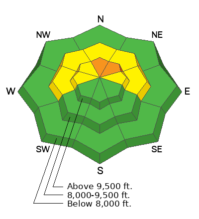
The overall avalanche danger is MODERATE on the Manti Skyline but a CONSIDERABLE danger exists in the upper elevation north northeast facing steep terrain.
Deep and dangerous human triggered avalanches are possible today on mid and upper elevation very steep slopes that face west, north and east but especially on high north northeast facing slopes.
The likelihood of triggering an avalanche is not all that great but the consequences if you do could be severe.
I do not trust the old weak sugary snow near the base of the snowpack and I will continue to avoid steep northerly facing terrain until I'm satisfied that it has gained enough strength to be deemed "stable".
Low
Moderate
Considerable
High
Extreme
Learn how to read the forecast here
Weather and Snow
Current Conditions: Snowfall continued to trickle in Friday and overnight bringing snow totals since Thursday up to an average of 6 to 7 inches. The wind picked up a bit overnight from the west with moderate speeds and some stronger gusts along exposed locations. Temperatures have cooled to around 20˚F.
Mountain Weather: Light snow is still falling this morning and it might spit a bit more through the morning with no real accumulation anticipated. It looks like low level moisture may keep the mountains socked in with clouds for most of the day although there's a slight chance of some clearing later this afternoon. Temperatures will stay in the low 20s. Wind will be slightly breezy this morning from the west northwest then slow as the day goes on. We have a break in the weather on Sunday with partly cloudy skies then conditions cloud back up Monday ahead of another series of similar looking storms to this one that just moved through.
Ad
Avalanche Problem #1
Persistent Weak Layer
Type
Location
Likelihood
Size
Description
Weak snow near the base of the snowpack remains the biggest danger on the Skyline. Although not all that likely, there is still a distinct possibility that a person could trigger a deep avalanche with devastating consequences. The new snow and wind drifted snow in the higher terrain has increased the likelihood a bit but not all that much. What makes this situation dangerous is there is no way to know which slopes might avalanche and which ones will stay in place. The only sure way to stay out of trouble is to avoid slopes steeper than 30˚ in the mid and upper elevation terrain that face west, north and east, especially those higher elevation northeast facing steep slopes.
General Announcements
This forecast is from the U.S.D.A. Forest Service, which is solely responsible for its content. This forecast describes general avalanche conditions and local variations always occur.