Join us at our 2nd Annual Blizzard Ball

Forecast for the Provo Area Mountains

Nikki Champion
Issued by Nikki Champion on
Wednesday morning, March 15, 2023
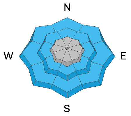
Due to heavy rainfall and natural wet-loose avalanche activity, the avalanche danger is currently HIGH at low elevations. At mid and upper elevations the avalanche danger is CONSIDERABLE but may spike to HIGH during periods of heavy snowfall this morning. High winds, warm temperatures, and heavy precipitation have created dangerous avalanche conditions. Both loose snow and slab avalanches may be possible within the wet snow at lower elevations, and new snow at mid and upper elevations. The elevated winds will continue to create unstable slabs of wind-drifted snow at all mid and upper elevations.
Today is not the day to spend on, or underneath any steep slopes at the lower elevation bands.
With strong winds, and overnight rainfall cornices and roof avalanches will be increasingly dangerous today.
Low
Moderate
Considerable
High
Extreme
Learn how to read the forecast here
Special Announcements
The UAC is currently working with the operation involved in Thursday's fatal avalanche in the Uintas to prepare a report. Please be patient as we sort out the details of this complicated incident. A preliminary report is available HERE.

Please consider donating to the spring campaign to help our team implement innovative tools and better provide you with the information you rely on.
Weather and Snow
This morning, temperatures are hovering above freezing. The rain/snow line is likely near 8,500' and it is heavily raining in the Provo area mountains. Remote weather stations are reporting 2-2.5" of snow, with 1.0-1.5" of water. The winds continue to blow from the southwest, at speeds of 20-40 mph with gusts up to 60 mph.
Today, there will be periods of heavy snowfall and graupel. The mountains could receive 2-5" of new snow, with 0.6-1.2" of water before 5 PM. Southwest winds will remain elevated, blowing 30-40 mph with gusts up to 70 mph. Midday the winds will begin shifting to the west, and then more northwesterly this afternoon. All said and done, the mountains could receive between 2.0-3.0" of water.
Tonight, things will begin to clear out with any light-snow showers arriving earlier this evening. The weather pattern looks to remain active into next week.
Recent Avalanches
Yesterday, a natural wet-loose cycle occurred between 2-6 PM in the Provo area mountains. This morning, there have already been reports of natural wet-loose activity occurring at low elevations.
We strive to understand patterns or hints of patterns with the snowpack and with avalanches to make a coherent assessment...and sometimes things aren't as clean cut as we would like. Forecaster Dave Kelly put some thoughts down on paper. His essay Early Morning Pattern Hunting-What's the Problem? is worth the read.

Get all observations HERE.
Ad
Avalanche Problem #1
Wet Snow
Type
Location
Likelihood
Size
Description
It is currently raining heavily in the Provo area mountains and only slated to continue throughout this morning before cold air pushes the rain line down. There have been reports of natural wet-loose avalanches occurring this morning. Today, natural and human-triggered wet loose avalanches will be very likely at the lower elevation bands, and maybe even the lower reaches of the mid-elevation band.
The main concern is having a naturally triggered slide come down onto you, especially if you are in a gully, couloir, or other confined terrain where avalanche debris can pile up deeper and you have no route for escape.
Keep the ice tools stowed: Surprisingly, there is still some ice climbing to be had across northern Utah but these crags will be very dangerous. The heavy precipitation this morning could trigger wet loose avalanches to run down the gullies and down the ice flows.
Avalanche Problem #2
Wind Drifted Snow
Type
Location
Likelihood
Size
Description
Due to the elevated winds that have accompanied this front, you'll likely find new and developing slabs of wind drifted snow at the upper elevations, and some mid-elevation sub ridges as well. As the winds continue to blow, these slabs will become more firm and more cohesive. This can allow you to travel out farther onto the slope before it breaks, and can fail larger and wider than expected. Winds have mostly been blowing from the south, southwest, but look for drifting on all aspects which can be loaded from the tops of ridges or across the sides of ridges.
Look for blowing and drifting snow and avoid any fresh deposits of wind blown snow.
CORNICES are currently large and growing and may be particularly sensitive and tender during periods of strong winds today. Give cornices a wide berth as they often break farther back than expected. Cornices are signs that a slope has been wind loaded and a cornice fall could trigger a larger slab of wind-drifted snow below.
Avalanche Problem #3
New Snow
Type
Location
Likelihood
Size
Description
The new snow issue is generally simple today, as the snowfall totals increases, the avalanche danger is going to increase as well. As of 5 AM roughly 1-4" inches of new snow has fallen throughout the Wasatch range and the front is predicted to have multiple periods of high snowfall rates this morning. This new snow is going to have a variety of excellent bed surfaces to slide on and I expect to see shallow new snow avalanches in the backcountry today.
Beyond this ongoing storm, we have had a lot of snow over the last few weeks and there are areas where we are finding decomposing stellar crystals, buried ice crusts, rime crusts, and isolated areas of faceted snow buried 1-3' from the surface and it's a good reminder that strange weather (like above average snowfall, and rain on snow) leads to strange avalanches. There is also a possibility of triggering an isolated slab avalanche on a new/old snow interface that is buried 1-3' from the surface. The solar aspects, particularly southeasterly facing slopes are acting more like a northerly aspect.
The type of avalanche, slab avalanche versus loose snow avalanche, will come down to how quickly the new snow bonds, versus how quickly the snow is falling from the sky. During any periods of higher rates of snowfall (greater than 1" per hour) avalanches will be easier to trigger. Pay attention to changing weather and increased snowfall rates. Watch for signs of instability such as cracking and sluffing
General Announcements
This information does not apply to developed ski areas or highways where avalanche control is normally done. This forecast is from the U.S.D.A. Forest Service, which is solely responsible for its content. This forecast describes general avalanche conditions and local variations always occur.