Join us at our 2nd Annual Blizzard Ball

Forecast for the Moab Area Mountains

Eric Trenbeath
Issued by Eric Trenbeath on
Monday morning, February 13, 2023
Expect changing conditions and a rising danger over the next several days!
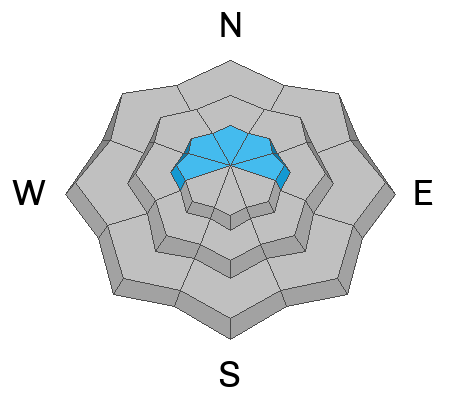
The avalanche danger is generally LOW this morning but could rise to MODERATE later today as new snow and southerly winds form fresh slabs of wind drifted snow on northerly aspects. Use caution on steep slopes that have fresh wind drifts approaching 6" deep, especially in areas of consequential terrain where even a small avalanche could sweep you off your feet and carry you over a cliff.
Low
Moderate
Considerable
High
Extreme
Learn how to read the forecast here
Special Announcements
Are you wondering how cell phones and other electronic devices can interfere with your avalanche transceiver? The "20/50 Rule" is that you want your beacon 20cm (8") away from other electronics while transmitting and 50cm (20") away from electronics while searching. Get the full scoop here.
Geyser Pass Road: The road is plowed and widened with a snow packed surface.
Grooming: Trails were last groomed on Monday.
Weather and Snow
6:00 a.m. Snow and Weather Data
24 Hour Snow 0" 72 Hour Snow 0" Season Total Snow 186" Base Depth at Gold Basin 68"
Winds on Pre Laurel Peak SSE 20 G30 Temp 28F

Weather
SE winds are back at it blowing in the 20-30 mph range along ridge tops. A low pressure system spinning into southern Arizona will track NE through the 4 Corners today bringing snow to the mountains of the desert Southwest. Though accumulations for the La Sals look fairly light, in the 2"-4" range, we could see periods of heavy snowfall mid-day. A more potent system is shaping up for late Tue-Wed with up to a foot of snow possible.

General Conditions
A change is in the air and our battered snow surface is about to get a refresh. In the meantime, it's going to be a bit rugged out there today until new snow starts to pile up. Stick to sheltered, north facing trees for the best conditions. Pay attention to blowing and drifting snow patterns, and avoid steep slopes that have more than about 6" of freshly drifted snow.
Chris Benson was out and about in the South Mountain region yesterday and he observed weakening surface snow in some areas with intermittent winds slabs on top. Dave Garcia made a similar observation a week ago. Although not a widespread problem at this time, as weak surface snow and older slabs get covered up, the danger for deeper avalanches will likely increase.

Snowpack and Weather Data
Gold Basin Storm Stake (10,000')
Gold Basin SNOTEL site (10,000')
SNOTEL site near Geyser Pass Winter Trailhead (9600')
Wind Station on Pre-Laurel Peak (11,400')
NWS forecast for the La Sal Mountains.
Recent Avalanches
No new avalanches were reported in the backcountry. See the La Sal Avalanche database here.
Ad
Avalanche Problem #1
Wind Drifted Snow
Type
Location
Likelihood
Size
Description
The danger for avalanches involving fresh slabs of wind drifted snow may be on the rise today if higher end snow totals materialize. Be on the lookout for sensitive fresh drifts on the leeward sides of ridge crests and terrain features in upper elevation, wind exposed terrain that faces primarily the north half of the compass. Look for signs of instability such as cracking in the snow surface, and suspect slopes steeper than 30 degrees that have more than about 6" of drifted snow.
Additional Information
With a likely rise in danger over the next few days, take the time to refresh what each level of the North American Public Avalanche Danger Scale means.
General Announcements
This forecast is from the U.S.D.A. Forest Service, which is solely responsible for its content. This forecast describes general avalanche conditions and local variations always occur. This forecast will be updated by 7:30 tomorrow morning.