UDOT PLANNED AVALANCHE CLOSURES!!

Observation: Middle Cirque

Observation Date
2/6/2023
Observer Name
Garcia
Region
Moab » Gold Basin » Middle Cirque
Location Name or Route
Gold Basin/Middle Cirque
Weather
Sky
Broken
Precipitation
Light Snowfall
Wind Direction
Northwest
Wind Speed
Light
Weather Comments
The sun was in and out today. At times, there was plenty of direct sunshine, and other times it was socked in and snowing lightly with no additional accumulation.
Snow Characteristics
New Snow Depth
3"
New Snow Density
Low
Snow Surface Conditions
Powder
Dense Loose
Snow Characteristics Comments
Three inches provides a very nice refresh. The skiing was better than it sounds on paper. Kind of a sleeper pow day today. The snow fell around 11 PM - 2 AM with Light to Moderate Westerlies. Winds bumped to Moderate in the early morning. I went looking for fresh wind slab formation and didn't find it.
Avalanche Problem #1
Problem
Wind Drifted Snow
Trend
Decreasing Danger
Problem #1 Comments
While skinning in Upper Middle Cirque I encountered old, hard, wind drifted snow. These drifts were at least 2-3 days old, probably formed Friday night into Saturday when there was a bump in the Southerly winds. Older drifts are generally harder to trigger, but this gave me some concern today. As I walked onto it from below, I heard the classic hollow, drum like sounds. With a hand shear I was able to pull the slab out with Moderate force and a Q2 shear. I found small grain facets (0.5mm) beneath the slab (down 29cm). These are the first facets I have seen in a while. I dug a hasty pit several hundred feet below this one and I did not find this structure, no wind slab and no facets. This seems like an isolated problem in Northerly aspects ATL. Certainly something to be aware of, as I know people have been getting into some extreme terrain lately. Keep an eye out for areas of wind drifted snow, if you find it, dig down and look for facets.
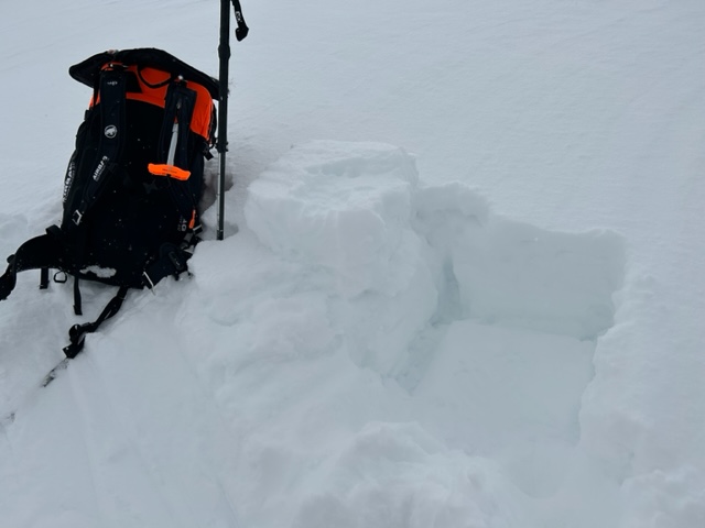
This is on a NE aspect at 11,750 ft. Slope angle is 36 degrees.
Today's Observed Danger Rating
Low
Tomorrows Estimated Danger Rating
Low
Coordinates