Join us for the 17th Annual Professional Snow and Avalanche Workshop (PROSAW) on November 4 - Purchase tickets here!

Forecast for the Logan Area Mountains

Toby Weed
Issued by Toby Weed on
Sunday morning, January 15, 2023
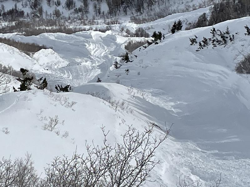
Heavy snowfall and drifting from winds blowing from the southeast will cause the avalanche danger to rise to CONSIDERABLE today on mid and upper elevation slopes facing every direction. Human triggered avalanches of storm snow will become likely on slopes steeper than 30°. People could trigger avalanches of wind drifted snow and sensitive wind slabs may be forming in unusual or unexpected places due to this morning's east wind. In some places, smaller avalanches overrunning a slope with poor snow structure could trigger larger, harder, and very dangerous avalanches failing on our now deeply buried persistent weak layer.
Cautious route-finding and conservative decision-making will be essential in the backcountry today.
Low
Moderate
Considerable
High
Extreme
Learn how to read the forecast here
Weather and Snow
The Tony Grove Snotel at 8400' reports a three inches of new snow from overnight. It's 26° F and there is 84 inches of total snow. At the 9700' CSI Logan Peak weather station, winds are blowing around 20 mph from the east-southeast and the temperature is 20° F.
The National Weather Service has continued a Winter Storm Warning for the Logan Zone through 11:00 tonight. Today, we can expect snow to fall heavily at times with 5 to 9 inches of accumulation expected. Expect high temperatures at 8500' around 30° F, but falling into the twenties in the afternoon, and moderate winds blowing from the southeast switching from the west in the afternoon.
Tonight snow is expected to taper off, and little accumulation is expected. Overnight temperatures will be around 14° F, and expect decreasing winds, 10 to 20 mph blowing from the west.
Tomorrow will be mostly cloudy with high temperatures around 25° F and 8 to 10 mph winds from the southwest.
--->Our next chance for significant snowfall comes with the next storm on Wednesday night and Thursday
Recent Avalanches
Widespread large natural avalanches occurred in the Wellsville Range during and at the end of this week's storm, some running into lower elevation bench areas. We had a chance to examine a huge one (or two) in Rattlesnake Canyon on Friday, and here's the report. No new avalanches were reported in the Logan Zone since last week's storm.
Ad
Avalanche Problem #1
New Snow
Type
Location
Likelihood
Size
Description
Soft slab and loose avalanches of storm snow will become likely as snow accumulates on steep slopes today. Natural avalanches may occur during periods of particularly heavy snowfall.
Avalanche Problem #2
Wind Drifted Snow
Type
Location
Likelihood
Size
Description
Even though this morning's east winds aren't all that strong they are drifting snow as it falls causing deep accumulations and wind slab formation west facing terrain and in unusual or perhaps unexpected places.
  • A smaller wind slab avalanche overrunning a slope with a poor snow structure could cause a much larger avalanche to step down to our now deeply buried November persistent weak layer.
  • Avoid fresh drifts on the lee side of prominent ridges, on corniced slopes, and in and around terrain features like cliff bands, mid-slope break overs, gully walls, sub ridges, saddles, and sinks.
  • Human-triggered avalanches 1-2' deep are possible in drifted areas.
Avalanche Problem #3
Persistent Weak Layer
Type
Location
Likelihood
Size
Description
People or small slides could trigger large and dangerous hard slab avalanches failing on a deeply buried persistent weak layer. Poor snow structure still exists in many places where a person could trigger the slope from an area where the hard slab is shallower, and a dangerous deep hard slab avalanche could result. A person might trigger and avalanche from around slope margins, in steep rocky terrain, and in generally shallow outlying mid and upper elevation areas. In the Logan Zone, terrain with generally shallower snow like the Wellsville Range and the Logan Peak Area is most suspect.
  • Although becoming more unlikely, an avalanche failing on a buried persistent weak layer could still be triggered remotely, from a distance or below.
  • Avalanches failing on sugary weak snow near the ground could be very large and long running, perhaps descending into lower elevations.
Additional Information
General Announcements
  • Remember, when you leave the ski area boundary, Beaver Mt or Cherry Peak, you are entering the backcountry, and you could trigger dangerous avalanches.
  • Please submit your observations from the backcountry HERE.
  • For a list of avalanche classes from the Utah Avalanche Center go HERE
  • For information on where you can ride your sled or snowbike, check out this map of the winter travel plan for the Tony Grove and Franklin Basin Areas HERE.
This forecast is from the U.S.D.A. Forest Service, which is solely responsible for its content. This forecast describes general avalanche conditions and local variations always occur.