Join us for the 17th Annual Professional Snow and Avalanche Workshop (PROSAW) on November 4 - Purchase tickets here!

Forecast for the Logan Area Mountains

Toby Weed
Issued by Toby Weed on
Saturday morning, January 14, 2023
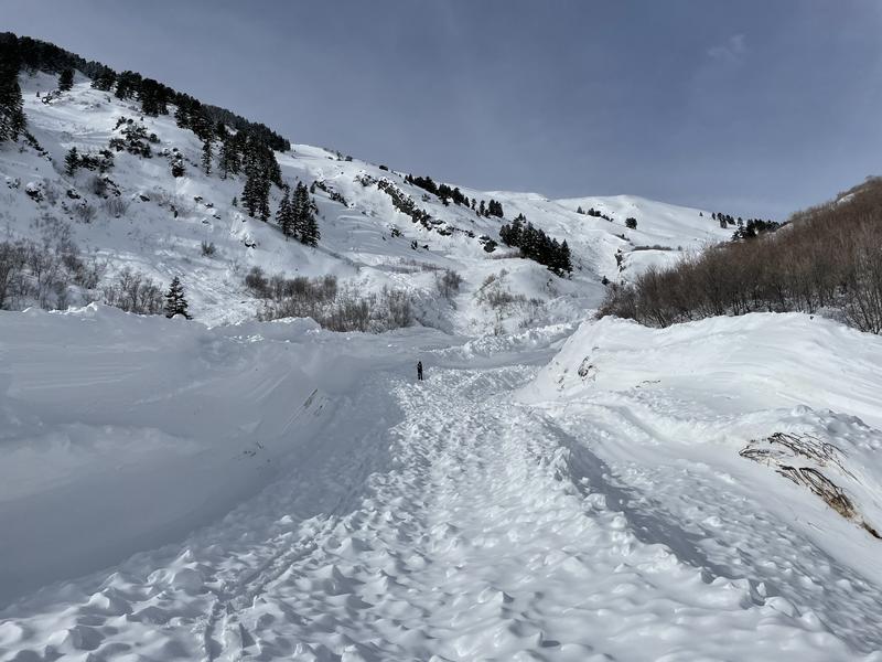
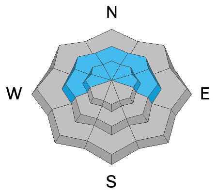
Elevated avalanche conditions exist on upper and mid elevation slopes across the Logan Zone. The danger is MODERATE and people could trigger large and dangerous avalanches of wind drifted snow failing on a deeply buried persistent weak layer. In some areas, wind exposed terrain with generally shallow snow cover and poor snow structure like in the Wellsville Range, more dangerous conditions exist in terrain facing west, north, and east. Cooler temperatures and clouds should help keep a lid on wet avalanche activity, but heavy snow and drifting from a Winter Storm will cause rising avalanche danger tonight and tomorrow.

Evaluate snow and terrain carefully.
Low
Moderate
Considerable
High
Extreme
Learn how to read the forecast here
Weather and Snow
The Tony Grove Snotel at 8400' reports a couple feet of heavy new snow with a whopping 3.5" of Snow Water Equivalent from this week's storm. It's 31° F and there is 83 inches of total snow. At the 9700' CSI Logan Peak weather station, winds are blowing 25-30 mph with gusts in the upper 50s from the south-southwest, and the temperature is 23° F.
The National Weather Service has issued a Winter Storm Warning for the Logan Zone, starting at 11:00 this morning and extending through 11:00 Sunday night. Today, we can expect mostly cloudy conditions and snow likely in the afternoon, with maybe a half inch of accumulation. Expect high temperatures at 8500' around 37° F and moderate winds blowing from the south-southwest. Tonight snow is expected and it could fall heavily at times, with 4 to 8 inches of accumulation expected at upper elevations. Overnight temperatures will rise to around 27° F, and expect increasing winds, 10 to 20 mph blowing from the southwest. Tomorrow snow is expected, with 3 to 7 inches of accumulation, temperatures dropping to around 20° F and 10 to 20 mph winds from the south, switching from the west in the afternoon.
*The moisture train continues to march on with unsettled weather and plenty of snow on tap for the upcoming week.
Recent Avalanches
Widespread large natural avalanches occurred in the Wellsville Range during and at the end of this week's storm, some running into lower elevation bench areas. We had a chance to examine a huge one (or two) in Rattlesnake Canyon on Friday, and I'm working on the report.
Large natural avalanches were less widespread in the Bear River Range, but an observer reports a large slide from early in the storm in northern Wood Camp. Many storm snow avalanches are likely now covered up by heavy snow from later in the storm.
Ad
Avalanche Problem #1
Persistent Weak Layer
Type
Location
Likelihood
Size
Description
People or small slides could trigger large and dangerous hard slab avalanches failing on a deeply buried persistent weak layer. Poor snow structure still exists in many places where a person could trigger the slope from an area where the hard slab is shallower, and a dangerous deep hard slab avalanche could result. A person might trigger and avalanche from around slope margins, in steep rocky terrain, and in generally shallow outlying mid and upper elevation areas. In the Logan Zone, terrain with generally shallower snow like the Wellsville Range and the Logan Peak Area is most suspect.
  • An avalanche failing on a buried persistent weak layer could still be triggered remotely, from a distance or below.
  • Avalanches failing on sugary weak snow near the ground could be very large and long running, perhaps descending into lower elevations.
Avalanche Problem #2
Wind Drifted Snow
Type
Location
Likelihood
Size
Description
Strong south and west winds earlier in the week transported plenty of snow. The wind picked up snow in fetch areas on windward slopes and in low angled terrain and deposited it on lee slopes and in terrain influenced deposition areas. The drifting built fresh slabs of thicker snow and added more weight to slopes with poor snow structure. South winds increased a notch last night, blowing 30 to 35 mph and gusting in the 50s drifting snow along the surface and depositing it on slopes in deceleration zones.
  • A smaller wind slab avalanche overrunning a slope with a poor snow structure could cause a much larger avalanche to step down to our now deeply buried November persistent weak layer.
  • As always, look for and avoid drifts on the lee side of prominent ridges, on corniced slopes, and in and around terrain features like cliff bands, mid-slope break overs, gully walls, sub ridges, saddles, and sinks.
  • Human-triggered avalanches 1-2' deep are possible in drifted areas.
Avalanche Problem #3
Wet Snow
Type
Location
Likelihood
Size
Description
Cooler temperatures helped to set up the saturated new snow and should diminish the danger of wet avalanches at lower elevations. However, avalanches are possible if the saturated surface snow is softened significantly by warm temperatures. At upper and mid elevations, the fresh snow on sunny slopes (if the sun peeks out) could get damp and prone to sluffing. Small wet loose avalanches overrunning a slope with buried persistent weak layers could cause a much larger hard slab avalanche.
General Announcements
  • Remember, when you leave the ski area boundary, Beaver Mt or Cherry Peak, you are entering the backcountry, and you could trigger dangerous avalanches.
  • Please submit your observations from the backcountry HERE.
  • For a list of avalanche classes from the Utah Avalanche Center go HERE
  • For information on where you can ride your sled or snowbike, check out this map of the winter travel plan for the Tony Grove and Franklin Basin Areas HERE.
This forecast is from the U.S.D.A. Forest Service, which is solely responsible for its content. This forecast describes general avalanche conditions and local variations always occur.