AVALANCHE WARNING!! Tap for info

Forecast for the Uintas Area Mountains

Craig Gordon
Issued by Craig Gordon on
Tuesday morning, December 6, 2022
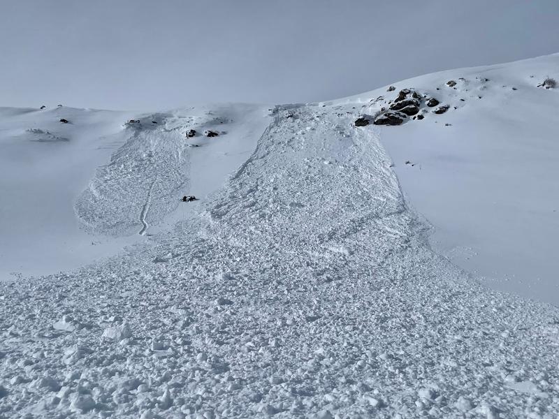
The snowpack teeters at a dangerous crossroads and avalanche danger remains tricky-
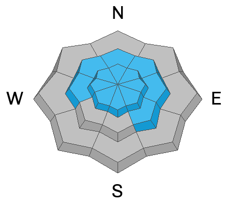
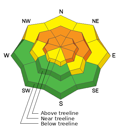
CONSIDERABLE avalanche danger is found on steep, mid and upper elevation slopes, especially those facing the north half of the compass, and particularly terrain with an easterly component to its orientation. Human triggered avalanches breaking to weak, sugary, midpack snow are LIKELY. Lower elevation shady slopes with similar layering offer MODERATE avalanche danger and human triggered avalanches are POSSIBLE
LOW avalanche danger is found on low and mid elevation south facing slopes and human triggered avalanches are UNLIKELY.

Here's my exit strategy to avoid avalanche danger and uncertainty- I've been finding excellent riding conditions and fun meadow skipping on mellow, low angle south facing slopes and big open meadows with no overhead hazard... (meaning, no steep slopes above or adjacent to where I'm traveling). Remember, don't get too throttle happy because it's still low tide and there's plenty of reef barely hidden underneath our recent storm snow. With a significant danger of hitting rocks, stumps, and other obstacles, you'll wanna tone it down today and don't let a buried treasure ruin your season.
Low
Moderate
Considerable
High
Extreme
Learn how to read the forecast here
Special Announcements
Please join me this Thursday at Inspired Summit Adventures for a free, "State... of the state... of the snowpack" presentation. It'll be informative, educational, and possibly even entertaining. Black tie optional :)
Inspired Summit Shop
8178 Gorgoza Pines Rd unit i
Park City, Utah 84098
Location HERE
Refreshments provided by ISA
In addition, join the Utah Avalanche Center and the Division of Outdoor Recreation to celebrate the Fourth Annual Avalanche Awareness week, from December 4 - December 11. Click HERE to view the full list of events for the week.

Mirror Lake Highway is closed for the season. SR-35 (Wolf Creek Pass) remains open.
Weather and Snow
Nowcast- What a nice way to start the week as yesterday's storm delivered a uniform 7" of snow with .50" H2O of cold creamy snow across the range. This morning, a big, bright, beautiful and nearly full "Cold Moon" casts amazing light on our mountains which are draped in a fresh coat of white paint. With clear skies overhead, temperatures dipped into the single digits overnight where they hover this morning. West and northwest winds blow in the teens and low 20's which equate to windchill registering near -15 degrees along the high ridges. But, with all-time early season conditions awaiting your arrival, I bet in just a few minutes you'll forget about the toe numbing temperatures.
Forecast- Expect a stunning day in the mountains with mostly sunny skies, light winds, and temperatures climbing into the low 20's. Overnight lows dip into the single digits.
Futurecast- Quiet weather is on tap until the weekend when a solid looking storm holds promise for the Saturday through Monday timeframe. We'll keep ya posting as the storm evolves.

Lots of excellent trip reports and recent obs are found HERE.
Recent Avalanches
No new avy activity for a few days, but this slide near the Mill Hollow Trailhead clearly paints the picture of a weak snowpack overloaded by last Friday's robust storm which produced widespread avalanche activity across the range.
No shortage of avalanches from the weekend and the common theme is this... avalanches are getting triggered remotely (meaning from a distance), breaking 2' deep and up to 200' wide, and are failing on weak faceted snow formed during the very cold, mid November dryspell. More deets found HERE.
Ad
Avalanche Problem #1
Persistent Weak Layer
Type
Location
Likelihood
Size
Description
Once initiated, a small avalanche can break into weak layers of snow buried in the mid portion of our snowpack, resulting in a slide that gets quickly out of hand.
The good news is... early season snow means we're off to a great start, the Uinta's are white, and travel is mostly easy. The bad news is... two weeks of dry, bitter cold weather during mid November, created a layer of very weak, sugary facets on the snow surface which are now preserved underneath several storms and buried in the mid portion of our snowpack. Here's where the rubber hits the road and what makes things tricky right now... any avalanche that fails near our new problem child, the persistent weak layer or (PWL), is gonna break deep and wide and it's gonna be dangerous.
Unless you take your shovel out, dig down and investigate a bit, you can easily get lulled into a false sense of snow stability because the snowpack has gained a substantial amount of buoyancy and will feel strong and solid underneath us. But remember- hard, dense snow resting on weak, sugary snow can give us a false sense of snow stability, allowing us to get out further onto a slope before it fails and brings the entire roof down on top of us.
Obvious signs of unstable snow include cracking, collapsing, and whoomping noises as well as natures freebie... natural avalanches!
Upper elevation, north facing structure
Mid elevation Southeast facing structure
Additional Information
And we've been super busy this summer upgrading the western Uinta weather station network and this real-time info is found HERE (click weather stations, and then on the Western Uinta tab)
Your observations are important, so please let me know what you're seeing... click HERE and contribute to this amazing community-based program
General Announcements
Issued at 03:59 on Tuesday December 6th, this forecast expires 24 hours after the date and time posted, but will be updated by 07:00 Wednesday December 7th.
Before it gets too crazy, now is the time to book an avalanche awareness presentation for your group, club, or posse. You can reach Craig directly at 801-231-2170 or [email protected].

This forecast is from the U.S.D.A. Forest Service, which is solely responsible for its content. This forecast describes general avalanche conditions and local variations always occur.