Join us at our 2nd Annual Blizzard Ball

Forecast for the Uintas Area Mountains

Craig Gordon
Issued by Craig Gordon on
Tuesday morning, April 12, 2022
Today you'll encounter MODERATE avalanche danger on steep, upper elevation, leeward slopes. Human triggered avalanches are POSSIBLE, especially in terrain facing the north half of the compass above treeline in the windzone. Mostly manageable in size, fresh wind drifts will react to our additional weight and may run a little further and faster, packing more punch than you might expect as they rest on top of a variety of slick, hard crusts.
Lose the wind and you lose the problem. LOW avalanche danger and legit late winter riding conditions are found on mid and low elevation wind sheltered slopes where human triggered avalanches are UNLIKELY.
Low
Moderate
Considerable
High
Extreme
Learn how to read the forecast here
Special Announcements
Sunday, April 17th is the last of our regularly scheduled daily forecasts for the western Uinta mountains. But, don't let your heart be troubled... I'll continue to update this page with intermittent forecasts if Mother Nature decides to keep the winter switch turned on.
Weather and Snow
NOWCAST-
Last night's storm raced out of the Gulf of Alaska and slid through the region right around dinnertime, slamming into the mountains like a cross-fire hurricane whilst delivering a solid 10" of snow with .80" H2O... pretty average snow densities for these parts. Yesterday's cow-tipping southwest winds switched to the west and northwest lockstep with the cold front and currently blow 30-50 mph near the high peaks. Scattered snow showers linger over the area and finger numbing temperatures register in the single digits and low teens. Riding and turning conditions went from zero to hero overnight!
FORECAST-
A break in the action this morning brings scattered snow showers which stack up another couple inches of snow. Northwest winds blowing in the 40's near the high peaks will be a nuisance. Winter-like temperatures don't stray much from where we're at this morning and overnight lows crash into negative territory.
FUTURECAST-
Another shot of snow is expected tonight, with unsettled weather on tap for Wednesday and Thursday. The work week wraps up with a drying trend.
Trip reports and snowpack observations are found HERE.

Looking for real-time temps, snow, or wind? Click HERE and then on the "western Uinta" tab for western Uinta specific, weather station network.
Recent Avalanches
No significant avalanche activity to report.
An archive of recent slides is found HERE.

Your input is vital and we're interested in what you're seeing. Please contribute to this great community resource and go here to fill out an observation.
Ad
Avalanche Problem #1
Wind Drifted Snow
Type
Location
Likelihood
Size
Description
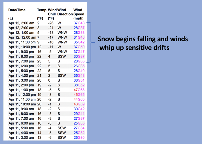
A 24 hour data dump from Windy Peak (10,662') shows strong winds will have no problem whipping fresh storm snow into sensitive drifts in upper elevation terrain.
The good news is... with no myriad of weak layers to deal with or analyze, there's no mystery in the snowpack. In fact, today's avalanche dragon is pretty straight-forward and linear. As snow began falling last night, winds cranked into the 40's and 50's, forming fresh drifts on the leeward side of upper elevation ridges and around terrain features like chutes and gullies. Easy to detect and easy to avoid, simply steer clear of fat rounded pieces of snow, particularly if they sound hollow like a drum. Lose some elevation, you lose the wind, you lose the problem, and you're rewarded with a solid base underfoot, topped off with cold, creamy snow.
Additional Information
Your observations are important, so please let me know what you're seeing... click HERE and contribute to this amazing community based program
General Announcements
The information in this forecast expires 24 hours after the day and time posted, but will be updated by 07:00 Wednesday, April 13th.
Before it gets too crazy, now is the time to book an avalanche awareness presentation for your group, club, or posse. You can reach me directly at 801-231-2170 or [email protected]
This forecast is from the U.S.D.A. Forest Service, which is solely responsible for its content. This forecast describes general avalanche conditions and local variations always occur.