Forecast for the Uintas Area Mountains

Craig Gordon
Issued by Craig Gordon for
Monday, April 11, 2022
Heads up... as today's storm evolves, avalanche danger begins changing in stride as well.
You'd be hard pressed to trigger an avalanche this morning and the danger is generally LOW. However, as the storm materializes I expect the avalanche danger will rise to MODERATE by late in the day. As new snow stacks up and winds continue cranking, human triggered avalanches will be POSSIBLE, especially on steep wind drifted slopes in the wind zone, near and above treeline
Low
Moderate
Considerable
High
Extreme
Learn how to read the forecast here
Special Announcements
Sunday, April 17th is the last of our regularly scheduled daily forecasts for the western Uinta mountains. But, don't let your heart be troubled... I'll continue to update this page with intermittent forecasts if Mother Nature decides to keep the winter switch turned on.
Weather and Snow
NOWCAST-
This mornings high clouds are the leading edge of a stormy period slated to settle in over the area 'til about Wednesday. Meanwhile back at the ranch... temperatures bottom out in the teens and low 20's this morning and southwest winds blow in the 20's and 30's along the high ridges. Riding and turning conditions are a mixed bag with soft snow is short supply.
FORECAST-
The graphic above lays out a timeline for the upcoming storm. Clouds thicken this morning and southwest winds ramp into the 40's and 50's as the day wares on. High temperatures crack into the upper 30's, but begin crashing as cold air filters into the region and light snow develops around suppertime. The storm kicks into gear and should begin stomping right around sunset with a foot of snow slated to stack up by early Tuesday.
FUTURECAST-
Snow showers with much colder temperatures are on tap for Tuesday, continuing in that spirit for Wednesday morning and storm totals in the 10"-20" range seem reasonable.
Trip reports and snowpack observations are found HERE.

Looking for real-time temps, snow, or wind? Click HERE and then on the "western Uinta" tab for western Uinta specific, weather station network.
Recent Avalanches
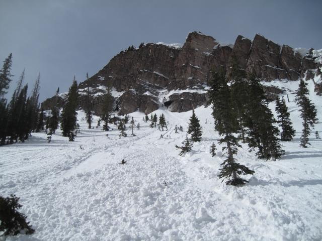
Ted was on the east side of the range Saturday near Whiskey Creek. He found this wet sluff that dribbled out of a steep, rock chute and entrained a healthy dose of snow as it fanned out on the slope below.
No other significant avalanche activity to report.
An archive of recent slides is found HERE.

Your input is vital and we're interested in what you're seeing. Please contribute to this great community resource and go here to fill out an observation.
Ad
Avalanche Problem #1
Wind Drifted Snow
Type
Location
Likelihood
Size
Description
A 24 hour data dump from Windy Peak (10,662') shows strong winds, but with no new snow to blow around, they're just a nuisance near the high peaks.
Not much going on 'til it starts storming, but once snow begins stacking up I expect fresh drifts will become sensitive to our additional weight. As the day wares on and snow begins piling up late in the day, look for and avoid fat, rounded pieces of snow, especially if they appear chalky or sound hollow like a drum.
Additional Information
Your observations are important, so please let me know what you're seeing... click HERE and contribute to this amazing community based program
General Announcements
The information in this forecast expires 24 hours after the day and time posted, but will be updated by 07:00 Tuesday, April 12th.
Before it gets too crazy, now is the time to book an avalanche awareness presentation for your group, club, or posse. You can reach me directly at 801-231-2170 or [email protected]
This forecast is from the U.S.D.A. Forest Service, which is solely responsible for its content. This forecast describes general avalanche conditions and local variations always occur.